
Where is Ross, Pennsylvania Located in the United States? Ross is a city located in the Allegheny County of Pennsylvania, United States. Ross lies between 40.5215 Degrees North latitudes and -80.0139 Degrees West longitudes.
Location Map of Ross in Allegheny County, Pennsylvania
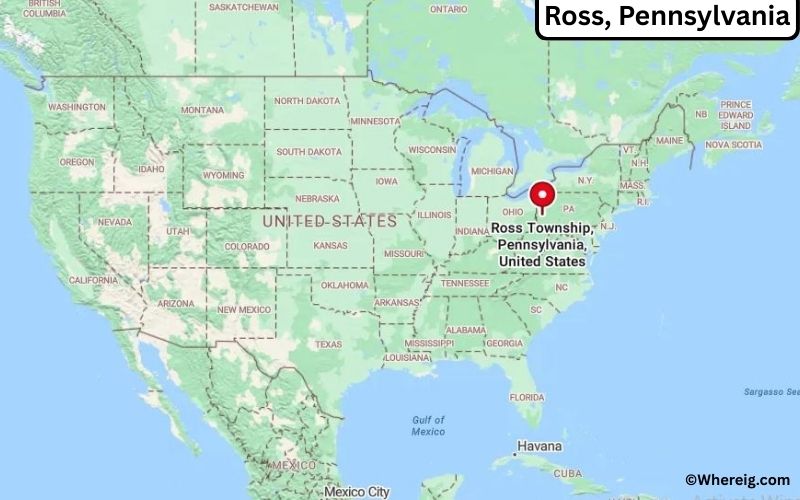
About Map: The map shows the location of Ross in the state of Pennsylvania, United States. Ross is a city in Allegheny County, Pennsylvania.
Ross Map, Pennsylvania, USA
About Ross Map: This interactive Google Map shows the exact location of Ross in Pennsylvania, United States. You can zoom in or out, switch to satellite view, and explore nearby cities, roads, and local landmarks around Ross.
About Ross, Allegheny County, Pennsylvania
Ross is a township located in Allegheny County in the U.S. state of Pennsylvania, United States. Situated in western Pennsylvania just north of Pittsburgh, the township is part of the Pittsburgh metropolitan area and serves as a residential and commercial community within Allegheny County. Ross was established in 1809 and was named after James Ross, a prominent early political leader. The township has developed into a suburban area with a mix of neighborhoods, businesses, and community services.
Population
According to the United States Census Bureau, the population of Ross is 31,105 as recorded in the 2020 Census, and the population density is approximately 2,700 people per square mile.
Geography
According to the United States Census Bureau, Ross covers a total area of approximately 11.0 square miles (about 28.49 square kilometers), including about 10.9 square miles (28.23 square kilometers) of land and about 0.1 square miles (0.26 square kilometers) of water.
Location and Surroundings
Ross is located in western Pennsylvania within Allegheny County, approximately 6 miles north of Pittsburgh. The surrounding region features suburban neighborhoods, commercial districts, and nearby urban areas that contribute to the township’s character.
Top Attractions in the City
Ross offers parks, recreational facilities, and community attractions for residents and visitors. North Park, located nearby, is a major destination offering trails, lakes, and outdoor recreation opportunities. Local parks and community spaces provide additional facilities for sports, events, and gatherings.
Transportation
Ross is served by major roadways including Interstate 279 and U.S. Route 19, providing convenient access to Pittsburgh and surrounding areas. Public transit services also connect the township to the greater Pittsburgh region. The nearest major airport serving the area is Pittsburgh International Airport, located about 20 miles west of the township.
Explore more cities and counties across Pennsylvania or view the complete USA States Map for additional geographic information.
Sources:
Population and area data sourced from the United States Census Bureau (2020 Census). General information referenced from the Official Ross Township Website.
Most Viewed US Maps
| USA Sttae Map | USA Region Map | USA Road Map |
| USA County Map | Where is USA in World Map? | US ZIP Code Map |
| USA Time Zones Map | US State and Capitals Map | USA Physical Map |
Find 4,400+ U.S. Cities by State - Explore Their Locations and Get Detailed Information
Ross, Pennsylvania City Facts
| City | Ross |
| State | Pennsylvania |
| County | Allegheny County |
| Country | United States |
| Region | Western Pennsylvania |
| Founded | 1809 |
| Incorporated | 1809 (Township) |
| Total Area | Approximately 23.4 sq mi (60.6 km²) |
| Land Area | Approximately 23.4 sq mi (60.6 km²) |
| Water Area | Approximately 0.0 sq mi (0.0 km²) |
| Elevation | Approximately 1,100 ft (335 m) |
| Population (2023 estimate) | Approximately 31,000+ |
| Population (2020 Census) | 31,105 |
| Population Density | Approximately 1,330 people per sq mi |
| Time Zone | Eastern Time (UTC-5 / UTC-4 DST) |
| ZIP Codes | 15214, 15229, 15237 |
| Area Code | 412, 878 |
| Major Highways | Interstate 279, U.S. Route 19, Pennsylvania Route 65 (nearby) |
| Public Transit | Pittsburgh Regional Transit (PRT) |
| Major Attractions | Ross Park Mall, North Park nearby, Evergreen Community Park |
| Official Website | https://www.ross.pa.us/ |
Transportation and Connectivity in Ross, Pennsylvania
| Transportation Type | Details |
|---|---|
| Airport Name | Pittsburgh International Airport |
| IATA Code | PIT |
| Port | Ohio River and Pittsburgh regional river transportation access |
| Major Highways | Interstate 279, U.S. Route 19, U.S. Route 19 Truck, McKnight Road |
| Train/Amtrak Service | Amtrak service available at Pittsburgh Station |
| Local Bus/Transit Service | Port Authority of Allegheny County bus service |
- Interstate 279 (I-279): Major highway connecting Ross Township with downtown Pittsburgh and northern suburbs.
- U.S. Route 19: Important north-south route serving Ross and surrounding Allegheny County communities.
- McKnight Road: Major commercial corridor with shopping, dining, and regional connections.
- Pittsburgh International Airport: Main commercial airport serving Ross and the Pittsburgh metropolitan area.
Top Places to Visit in Ross, Pennsylvania
| Landmark Name | Type |
|---|---|
| North Park | County Park |
| North Park Lake | Recreation Area |
| Ross Township Community Center | Community Facility |
| Shaler North Hills Library | Library and Community Center |
| La Roche University Campus | Educational Landmark |
| Hartwood Acres Park | Historic Park |
| Allegheny Observatory | Historic Science Attraction |
| Pittsburgh Zoo & Aquarium | Zoo and Aquarium |
| Carnegie Science Center | Science Museum |
| Point State Park | Historic Park |
Driving Distances from Ross, Pennsylvania to Nearby Cities
| City | State | Distance (mi) | Approx. Drive Time |
|---|---|---|---|
| Pittsburgh | Pennsylvania | 8 mi | 15 minutes |
| McKees Rocks | Pennsylvania | 10 mi | 20 minutes |
| Monroeville | Pennsylvania | 25 mi | 35 minutes |
| Washington | Pennsylvania | 40 mi | 45 minutes |
| Butler | Pennsylvania | 35 mi | 45 minutes |
| Greensburg | Pennsylvania | 45 mi | 55 minutes |
| Morgantown | West Virginia | 75 mi | 1 hour 20 minutes |
| Erie | Pennsylvania | 125 mi | 2 hours |
| Cleveland | Ohio | 135 mi | 2 hours 15 minutes |
| Harrisburg | Pennsylvania | 220 mi | 3 hours 30 minutes |
Colleges and Universities Near Ross, Pennsylvania
| Institution Name | Type | Level | Notable For |
|---|---|---|---|
| La Roche University | Private | University | Business, healthcare, education, design, and professional programs |
| Community College of Allegheny County - North Campus | Public | Community College | Career training, technology, healthcare, and transfer programs |
| University of Pittsburgh | Public | University | Research, medicine, engineering, and professional studies |
| Carnegie Mellon University | Private | University | Computer science, engineering, technology, and research |
| North Hills School District | Public | K–12 District | Primary and secondary education |
Waterbodies Near Ross, Pennsylvania
Ohio River, Allegheny River, Pine Creek, North Park Lake, and nearby waterways of Allegheny County.
Golf Courses Near Ross
North Park Golf Course, Pittsburgh Field Club, Allegheny Country Club, Wildwood Golf Club, and Schenley Park Golf Course.
Ross, Pennsylvania — Key Historical Facts
- Ross Township was established in 1809 and was named after James Ross, a Pennsylvania politician and U.S. senator.
- The township developed from farmland into a suburban community as the Pittsburgh region expanded.
- Ross became an important residential area because of its location near downtown Pittsburgh and major transportation routes.
- North Park, one of Allegheny County’s largest parks, became a major recreation destination for residents and visitors.
- The township continues to serve as a residential and commercial center in northern Allegheny County.
Stadiums and Sports Facilities Near Ross
| Facility Name | Type | Location |
|---|---|---|
| North Park Sports Facilities | Community Sports Facility | McCandless, Pennsylvania |
| North Hills High School Stadium | High School Sports Stadium | West View, Pennsylvania |
| La Roche University Athletic Facilities | College Sports Facility | Pittsburgh, Pennsylvania |
| Acrisure Stadium | Professional Football Stadium | Pittsburgh, Pennsylvania |
| PNC Park | Major League Baseball Stadium | Pittsburgh, Pennsylvania |
References
- Ross Township Official Website
- Allegheny County Government
- U.S. Census Bureau
- Visit Pittsburgh Tourism
- La Roche University
Pennsylvania More Maps & Info
- Where is Abington
- Where is Bensalem
- Where is Bristol
- Where is Buckingham
- Where is Cheltenham
- Where is Coolbaugh
- Where is Cranberry
- Where is Derry
- Where is Dover
- Where is East Hempfield
- Where is East Pennsboro
- Where is Exeter
- Where is Falls
- Where is Hampden
- Where is Haverford
- Where is Hempfield
- Where is Lower Macungie
- Where is Lower Makefield
- Where is Lower Merion
- Where is Lower Paxton
- Where is Lower Providence
- Where is Manheim
- Where is Marple
- Where is McCandless
- Where is Middletown
- Where is Millcreek
- Where is Montgomery
- Where is Moon
- Where is Mount Lebanon
- Where is North Huntingdon
- Where is Northampton
- Where is Palmer
- Where is Penn Hills
- Where is Peters
- Where is Pottstown
- Where is Radnor
- Where is Ridley
- Where is Ross
- Where is Shaler
- Where is Spring
- Where is Springettsbury
- Where is Springfield
- Where is Susquehanna
- Where is Swatara
- Where is Tredyffrin
- Where is Unity
- Where is Upper Darby
- Where is Upper Dublin
- Where is Upper Macungie
- Where is Upper Merion
- Where is Upper Moreland
- Where is Upper Providence
- Where is Warminster
- Where is Warrington
- Where is West Goshen