
Fayetteville is a city in northwest Arkansas and the county seat of Washington County. It is about 30 miles south of Missouri and sits in the scenic Ozark Mountains. The city is known for the University of Arkansas, historic downtown Fayetteville, Dickson Street, the Botanical Garden of the Ozarks, and its strong connection to outdoor recreation.
Location Map of Fayetteville, Washington County, Arkansas
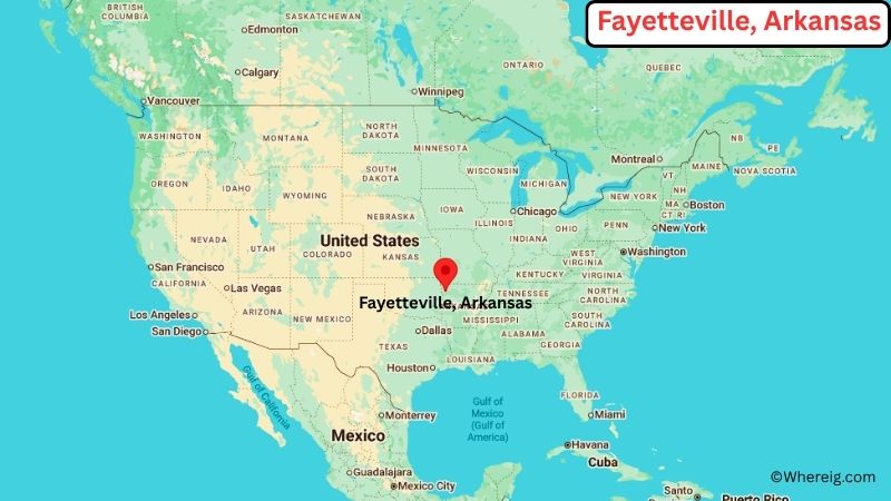
About Map: The map shows the location of Fayetteville in Washington County, in the U.S. state of Arkansas.
Fayetteville Map, Arkansas
About Fayetteville Map: The Google Map highlights the location of Fayetteville in Washington County, Arkansas. Use the zoom, satellite, and street-view options to explore the city's neighborhoods, roads, and nearby places.
Where is Fayetteville Located?
Fayetteville is a city located in Washington County, Arkansas, the United States. It lies in the Ozark Mountains of northwest Arkansas, about 30 miles south of the Missouri state line, 27 miles east of Oklahoma, and roughly 125 miles northwest of Little Rock. Fayetteville is positioned at approximately 36.082° North latitude and 94.171° West longitude. The city covers about 55.66 square miles, or 144.16 square kilometers, of land. The 2020 Census recorded 93,949 residents, while the 2023 population estimate was about 101,000. Fayetteville stands at an elevation of roughly 1,400 feet above sea level. The University of Arkansas is the city's most prominent institution and contributes strongly to its culture and economy. Historic downtown Fayetteville, Dickson Street, and the surrounding Ozark landscape are major attractions. The city also serves as a regional center for northwest Arkansas and lies close to Bentonville, Springdale, and Rogers, forming one of the state's fastest-growing urban areas.
Most Viewed US Maps
| USA Sttae Map | USA Region Map | USA Road Map |
| USA County Map | Where is USA in World Map? | US ZIP Code Map |
| USA Time Zones Map | US State and Capitals Map | USA Physical Map |
Find 4,400+ U.S. Cities by State - Explore Their Locations and Get Detailed Information
Fayetteville City Facts
| City | Fayetteville |
|---|---|
| State | Arkansas |
| County | Washington County |
| Country | United States |
| Region | Northwest Arkansas, Ozark Mountains |
| Incorporated | 1841 |
| Founded | 1828 |
| Total Area | 55.66 sq mi (144.16 sq km) |
| Land Area | 55.45 sq mi (143.62 sq km) |
| Water Area | 0.21 sq mi (0.54 sq km) |
| Elevation | 1,400 ft (427 m) |
| Population (2023 estimate) | About 101,000 |
| Population (2020 Census) | 93,949 |
| Population Density | 1,693.7 people per sq mi |
| Time Zone | Central Time (CST/CDT) |
| ZIP Codes | 72701, 72702, 72703, 72704 |
| Area Code | 479 |
| Major Highways | Interstate 49, U.S. Route 62, U.S. Route 71 |
| Public Transit | Ozark Regional Transit |
| Major Attractions | University of Arkansas, Dickson Street, Fayetteville Downtown Square, Botanical Garden of the Ozarks, Mount Sequoyah |
| Official Website | https://www.fayetteville-ar.gov/ |
Distance from Fayetteville, AR to Nearby Cities
- Springdale, AR – 10 miles (16 km)
- Farmington, AR – 8 miles (13 km)
- Johnson, AR – 5 miles (8 km)
- Bethel Heights, AR – 10 miles (16 km)
- Prairie Grove, AR – 12 miles (19 km)
- Lincoln, AR – 18 miles (29 km)
- Tontitown, AR – 12 miles (19 km)
- Rogers, AR – 22 miles (35 km)
- Bentonville, AR – 27 miles (43 km)
- Bella Vista, AR – 35 miles (56 km)
- Siloam Springs, AR – 30 miles (48 km)
- Fort Smith, AR – 60 miles (97 km)
- Harrison, AR – 65 miles (105 km)
- Joplin, MO – 90 miles (145 km)
- Tulsa, OK – 115 miles (185 km)
- Little Rock, AR – 125 miles (201 km)
- Springfield, MO – 130 miles (209 km)
- Oklahoma City, OK – 220 miles (354 km)
Top Attractions in Fayetteville
- University of Arkansas – The state's flagship public university, with a historic campus, museums, athletic venues, and cultural programs.
- Dickson Street – A lively historic street near the University of Arkansas known for restaurants, shops, music venues, and local events.
- Fayetteville Downtown Square and Gardens – The historic center of the city with the Old Post Office, courthouse, local businesses, and public gardens.
- Botanical Garden of the Ozarks – A large garden featuring themed plant collections, walking paths, seasonal displays, and educational programs.
- Mount Sequoyah – A scenic hilltop area overlooking Fayetteville and the surrounding Ozark landscape.
- Lake Fayetteville – A city lake with walking and biking trails, fishing, boating, and outdoor recreation.
- Wilson Park – Fayetteville's oldest public park, featuring walking paths, gardens, playgrounds, and the historic castle-like stone structure.
- Arkansas Air and Military Museum – A nearby museum displaying historic aircraft, military vehicles, and aviation artifacts.
- Razorback Stadium – The University of Arkansas football stadium and one of the city's best-known sports landmarks.
- Devil's Den State Park – A nearby Ozark state park with sandstone rock formations, trails, caves, camping, and Lake Devil.
Airports Near Fayetteville
- Northwest Arkansas National Airport (XNA) – 28 miles
- Drake Field (FYV) – 5 miles
- Fort Smith Regional Airport (FSM) – 65 miles
- Springfield-Branson National Airport (SGF) – 130 miles
- Tulsa International Airport (TUL) – 120 miles
Sources:
Population and area data sourced from the United States Census Bureau (2020 Census). General city information referenced from the official City of Fayetteville website and local government records.
Arkansas Related Links
- Where is Arkadelphia
- Where is Batesville
- Where is Beebe
- Where is Benton
- Where is Bentonville
- Where is Blytheville
- Where is Bryant
- Where is Cabot
- Where is Camden
- Where is Centerton
- Where is Clarksville
- Where is Conway
- Where is El Dorado
- Where is Farmington
- Where is Forrest City
- Where is Fort Smith
- Where is Greenwood
- Where is Harrison
- Where is Helena-West Helena
- Where is Hope
- Where is Hot Springs
- Where is Hot Springs Village
- Where is Jonesboro
- Where is Little Rock
- Where is Lowell
- Where is Magnolia
- Where is Malvern
- Where is Marion
- Where is Maumelle
- Where is Monticello
- Where is Mountain Home
- Where is Newport
- Where is North Little Rock
- Where is Paragould
- Where is Pine Bluff
- Where is Pocahontas
- Where is Prairie Grove
- Where is Rogers
- Where is Russellville
- Where is Searcy
- Where is Sherwood
- Where is Siloam Springs
- Where is Springdale
- Where is Stuttgart
- Where is Texarkana
- Where is Van Buren
- Where is West Memphis
- Where is Wynne