Written and Fact-checked by Whereig Editors, Reviewed by Mukesh Kumar| Last Updated On: May 10, 2026
Map of Washington County - Washington County is a county located in the U.S. state of Arkansas. Washington County Map showing cities, highways, important places and water bodies. Get Where is Washington County located in the map, major cities in Washington county, population, areas, and places of interest.
Washington County Map, Arkansas
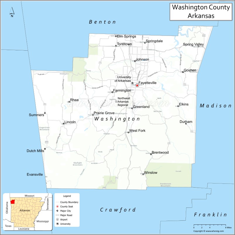
About Washington County Map, Arkansas: The map showing the county boundary, county seat, major cities, highways, water bodies and neighbouring counties.
Related Arkansas & US Links
Map of Washington County, Arkansas
Washington County is a county located in the U.S. state of Arkansas. It's county seat is Fayetteville. As per 2020 census, the population of Washington County is 250057 people and population density is square miles. According to the United States Census Bureau, the county has a total area of 951.72 sq mi (2,465 km2). Washington County was established on -26006.
Washington County Facts
| Continent | North America |
| Country | United States |
| State | Arkansas |
| County Seat | Fayetteville |
| Largest City/Town | Fayetteville |
| Established | November 30, 1848 |
| Total Area | 951 sq mi (2,463 sq km) |
| Land Area | 945 sq mi (2,448 sq km) |
| Water Area | 6 sq mi (15 sq km) |
| Population | 245,871 (Census 2020) |
| Population Density | 260.2 people per sq mi |
| Time Zone | Central Time Zone (CT) |
| Major Highways | Interstate 49, US 62, US 71, AR 16, AR 45 |
| Major Rivers | White River, Illinois River |
| Neighboring Counties | Benton County, Madison County, Crawford County, Franklin County, Adair County (OK) |
| Famous For | University of Arkansas, Fayetteville, Ozark Mountains, Razorbacks athletics, Northwest Arkansas growth |
| Top Attractions | University of Arkansas, Devil’s Den State Park, Botanical Garden of the Ozarks, Dickson Street |
| Official Website | Official Website |
About Washington County, Arkansas
Washington County is located in northwest Arkansas in the United States and was established in 1848. The county seat is Fayetteville, which is also the largest city in the county. The county lies within the Ozark Mountains region and is known for the University of Arkansas, rapid economic growth, outdoor recreation, arts and culture, and Razorbacks athletics.
Cities and Towns in Washington County, Arkansas
| City/Town | Population (Census 2020) | Latitude & Longitude |
|---|---|---|
| Fayetteville (county seat) | 93,949 | 36.0626°N, 94.1574°W |
| Springdale (partial) | 84,161 | 36.1867°N, 94.1288°W |
| Prairie Grove | 7,045 | 35.9751°N, 94.3177°W |
| Farmington | 7,584 | 36.0420°N, 94.2472°W |
| Lincoln | 2,772 | 35.9495°N, 94.4236°W |
| Elkins | 3,602 | 36.0017°N, 94.0080°W |
| Greenland | 1,259 | 35.9948°N, 94.1755°W |
| West Fork | 2,493 | 35.9240°N, 94.1883°W |
| Winslow | 365 | 35.8017°N, 94.1358°W |
| Johnson | 3,354 | 36.1320°N, 94.1677°W |
Golf Courses in Washington County, Arkansas
| Golf Course | Location | Latitude & Longitude |
|---|---|---|
| Blessings Golf Club | Fayetteville | 36.0891°N, 94.2202°W |
| Stonebridge Meadows Golf Club | Fayetteville | 36.0609°N, 94.2455°W |
| Paradise Valley Athletic Club Golf Course | Fayetteville | 36.1095°N, 94.1184°W |
| Shadow Valley Country Club nearby | Rogers | 36.3257°N, 94.1548°W |
Roads and Highways in Washington County, Arkansas
Major highways connect the county to the rest of Northwest Arkansas and neighboring states.
- Interstate 49 - major north-south interstate linking Fayetteville with Bentonville, Fort Smith, and Louisiana
- US Highway 62 - important east-west route through northwest Arkansas communities
- US Highway 71 - historic transportation route through the Ozark region
- Arkansas Highway 16 - scenic roadway serving rural mountain and recreation areas
- Arkansas Highway 45 - regional route connecting Fayetteville with nearby towns
What Are the Neighboring Counties of Washington County
- Benton County (north)
- Madison County (east)
- Franklin County (south)
- Crawford County (southwest)
- Adair County, Oklahoma (west)
Whar Are the Top Attractions in Washington County, Arkansas
The county offers a mix of natural and cultural attractions.
- University of Arkansas - flagship university known for academics, athletics, and Razorbacks sports
- Devil’s Den State Park - scenic park with caves, hiking trails, camping, and mountain views
- Botanical Garden of the Ozarks - garden attraction with themed landscapes and educational exhibits
- Dickson Street - entertainment district with restaurants, nightlife, and music venues
- Prairie Grove Battlefield State Park - preserved Civil War battlefield and museum
- Walton Arts Center - performing arts venue hosting concerts, theater, and cultural events
- Lake Fayetteville - recreation area with trails, boating, and fishing
- Clinton House Museum - historic home where Bill and Hillary Clinton once lived
- Ozark National Forest nearby - forest recreation area with hiking and scenic drives
- Fayetteville Downtown Square - historic district with shopping, dining, and farmers markets
- Illinois River recreation areas - floating, kayaking, and outdoor recreation destinations
- Baum-Walker Stadium - home stadium of the Arkansas Razorbacks baseball team
- Razorback Greenway - regional trail system connecting Northwest Arkansas communities
- Arkadia Retrocade - arcade and entertainment venue in Fayetteville
What is the Distance from Washington County to Nearby Cities
The following distances are measured by road (driving).
- Fayetteville to Bentonville (Benton County), Arkansas - 26 mi (42 km)
- Fayetteville to Fort Smith (Sebastian County), Arkansas - 61 mi (98 km)
- Fayetteville to Little Rock (Pulaski County), Arkansas - 190 mi (306 km)
- Fayetteville to Springdale (Washington County), Arkansas - 10 mi (16 km)
- Fayetteville to Rogers (Benton County), Arkansas - 21 mi (34 km)
- Fayetteville to Tulsa (Tulsa County), Oklahoma - 115 mi (185 km)
- Fayetteville to Joplin (Jasper County), Missouri - 88 mi (142 km)
- Fayetteville to Eureka Springs (Carroll County), Arkansas - 47 mi (76 km)
- Fayetteville to Branson (Taney County), Missouri - 86 mi (138 km)
- Fayetteville to Conway (Faulkner County), Arkansas - 150 mi (241 km)
- Fayetteville to Oklahoma City (Oklahoma County), Oklahoma - 215 mi (346 km)
- Fayetteville to Kansas City (Jackson County), Missouri - 227 mi (365 km)
FAQs about Washington County
Washington County is located in northwest Arkansas within the Ozark Mountains region.
Washington County had a population of 245,871 according to the 2020 United States Census.
Washington County is known for the University of Arkansas, Razorbacks athletics, Fayetteville, and outdoor recreation in Northwest Arkansas.
The major highways include Interstate 49, US Highway 62, US Highway 71, Arkansas Highway 16, and Arkansas Highway 45.
Yes, Washington County has several golf facilities including Blessings Golf Club and Stonebridge Meadows Golf Club.
References
- QuickFacts - U.S. Census Bureau
- United States Census Bureau
- United States Geological Survey (USGS)
- National Geodetic Survey
- Official Website
- Arkansas County Map
- Ashley County Map
- Baxter County Map
- Benton County Map
- Boone County Map
- Bradley County Map
- Calhoun County Map
- Carroll County Map
- Chicot County Map
- Clark County Map
- Clay County Map
- Cleburne County Map
- Cleveland County Map
- Columbia County Map
- Conway County Map
- Craighead County Map
- Crawford County Map
- Crittenden County Map
- Cross County Map
- Dallas County Map
- Desha County Map
- Drew County Map
- Faulkner County Map
- Franklin County Map
- Fulton County Map
- Garland County Map
- Grant County Map
- Greene County Map
- Hempstead County Map
- Hot Spring County Map
- Howard County Map
- Independence County Map
- Izard County Map
- Jackson County Map
- Jefferson County Map
- Johnson County Map
- Lafayette County Map
- Lawrence County Map
- Lee County Map
- Lincoln County Map
- Little River County Map
- Logan County Map
- Lonoke County Map
- Madison County Map
- Marion County Map
- Miller County Map
- Mississippi County Map
- Monroe County Map
- Montgomery County Map
- Nevada County Map
- Newton County Map
- Ouachita County Map
- Perry County Map
- Phillips County Map
- Pike County Map
- Poinsett County Map
- Polk County Map
- Pope County Map
- Prairie County Map
- Pulaski County Map
- Randolph County Map
- St Francis County Map
- Saline County Map
- Scott County Map
- Searcy County Map
- Sebastian County Map
- Sevier County Map
- Sharp County Map
- Stone County Map
- Union County Map
- Van Buren County Map
- Washington County Map
- White County Map
- Woodruff County Map
- Yell County Map
- Alabama Counties
- Alaska boroughs
- Arizona Counties
- Arkansas Counties
- California County Map
- Colorado Counties
- Connecticut Counties
- Delaware Counties
- Florida County Map
- Georgia County Map
- Hawaii Counties
- Idaho Counties
- Illinois Counties
- Indiana Counties
- Iowa Counties
- Kansas Counties
- Kentucky Counties
- Louisiana Counties
- Maine Counties
- Maryland Counties
- Massachusetts Counties
- Michigan County Map
- Minnesota Counties
- Mississippi Counties
- Missouri Counties
- Montana Counties
- Nebraska Counties
- Nevada Counties
- New York Counties
- New Hampshire Counties
- New Jersey Counties
- New Mexico Counties
- North Carolina Counties
- North Dakota Counties
- Ohio County Map
- Oklahoma Counties
- Oregon Counties
- Pennsylvania Counties
- Rhode Island Counties
- South Carolina Counties
- South Dakota Counties
- Map of Tennessee
- Texas County Map
- Utah Counties
- Vermont Counties
- Virginia Counties
- Washington Counties
- West Virginia Counties
- Wisconsin Counties
- Wyoming Counties