Written and Fact-checked by Whereig Editors, Reviewed by Mukesh Kumar| Last Updated On: May 10, 2026
Map of Fulton County - Fulton County is a county located in the U.S. state of Arkansas. Fulton County Map showing cities, highways, important places and water bodies. Get Where is Fulton County located in the map, major cities in Fulton county, population, areas, and places of interest.
Fulton County Map, Arkansas
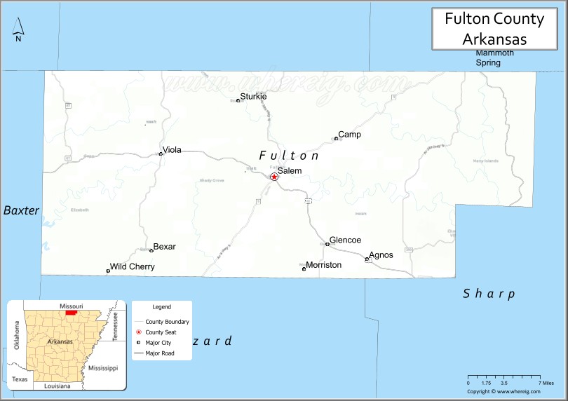
About Fulton County Map, Arkansas: The map showing the county boundary, county seat, major cities, highways, water bodies and neighbouring counties.
Related Arkansas & US Links
Map of Fulton County, Arkansas
Fulton County is a county located in the U.S. state of Arkansas. It's county seat is Salem. As per 2020 census, the population of Fulton County is 12145 people and population density is square miles. According to the United States Census Bureau, the county has a total area of 620.32 sq mi (1,607 km2). Fulton County was established on -20828.
Fulton County Facts
| Continent | North America |
| Country | United States |
| State | Arkansas |
| County Seat | Salem |
| Largest City/Town | Salem |
| Established | 1842 |
| Total Area | 620 sq mi (1,606 sq km) |
| Land Area | 618 sq mi (1,601 sq km) |
| Water Area | 2 sq mi (5 sq km) |
| Population | 12,075 (Census 2020) |
| Population Density | 19.5 people per sq mi |
| Time Zone | Central Time Zone (CST/CDT) |
| Major Highways | US Highway 62, US Highway 412, Arkansas Highway 9 |
| Major Rivers | Spring River, South Fork Spring River |
| Neighboring Counties | Baxter County, Izard County, Sharp County, Oregon County (MO), Howell County (MO) |
| Famous For | Ozark Mountain scenery, Spring River recreation, fishing, and rural outdoor tourism |
| Top Attractions | Mammoth Spring State Park nearby, Spring River, Salem town square, Ozark scenic drives |
| Official Website | Official Website |
About Fulton County, Arkansas
Fulton County is located in north-central Arkansas in the United States and was established in 1842. The county seat and largest city is Salem. Fulton County is known for Ozark Mountain landscapes, rivers and springs, fishing and floating recreation, and scenic rural communities near the Missouri border.
Cities and Towns in Fulton County, Arkansas
| City/Town | Population (Census 2020) | Latitude & Longitude |
|---|---|---|
| Salem (county seat) | 1,635 | 36.3717°N, 91.8226°W |
| Mammoth Spring | 977 | 36.4959°N, 91.5401°W |
| Cherokee Village (partly) | 4,780 | 36.2976°N, 91.5151°W |
| Viola | 337 | 36.3998°N, 91.9824°W |
| Glencoe | Small community | 36.2906°N, 91.7429°W |
| Gepp | Rural Ozark community | 36.4542°N, 91.9457°W |
| Spring River region | Outdoor recreation area | 36.4300°N, 91.6500°W |
| Ozark Highlands region | Mountain landscape area | 36.3800°N, 91.8200°W |
Golf Courses in Fulton County, Arkansas
| Golf Course | Location | Latitude & Longitude |
|---|---|---|
| Cherokee Village North Course | Cherokee Village | 36.2945°N, 91.5267°W |
| Cherokee Village South Course | Cherokee Village | 36.2752°N, 91.5421°W |
| Salem Golf Club | Salem | 36.3728°N, 91.8194°W |
Roads and Highways in Fulton County, Arkansas
Major highways connect the county to the Ozark Mountains, Missouri border communities, and north-central Arkansas.
- US Highway 62 - east-west route through Salem and northern Arkansas
- US Highway 412 - regional highway connecting the county with Missouri and the Ozarks
- Arkansas Highway 9 - scenic north-south route through mountain landscapes and rural communities
What Are the Neighboring Counties of Fulton County
- Baxter County (west)
- Izard County (southwest)
- Sharp County (east)
- Oregon County, Missouri (north)
- Howell County, Missouri (northeast)
Whar Are the Top Attractions in Fulton County, Arkansas
The county offers a mix of river recreation, mountain scenery, and small-town attractions.
- Mammoth Spring State Park nearby - one of the world’s largest springs with trails and exhibits
- Spring River - floating, kayaking, canoeing, and trout fishing destination
- Historic Salem town square - local shops, restaurants, and community events
- Ozark scenic drives - mountain views, forests, and rural landscapes
- Cherokee Village recreation areas - golf, lakes, and outdoor activities
- Fishing and boating opportunities throughout the county - rivers and lakes recreation
- Ozark hiking and wildlife observation areas - birdwatching and nature photography
- Historic railroad and pioneer heritage sites - regional history attractions
- Community fairs and Ozark festivals - celebrations of local traditions and culture
- Camping and picnic areas in forested regions - family outdoor recreation
- Spring-fed creeks and natural areas - photography and scenic exploration
- Nearby Missouri Ozarks access - mountain tourism and outdoor adventures
What is the Distance from Fulton County to Nearby Cities
The following distances are measured by road (driving).
- Salem to Mountain Home (Baxter County), Arkansas - 36 mi (58 km)
- Salem to Hardy (Sharp County), Arkansas - 29 mi (47 km)
- Salem to Batesville (Independence County), Arkansas - 61 mi (98 km)
- Salem to West Plains (Howell County), Missouri - 34 mi (55 km)
- Salem to Jonesboro (Craighead County), Arkansas - 122 mi (196 km)
- Salem to Springfield (Greene County), Missouri - 122 mi (196 km)
- Salem to Little Rock (Pulaski County), Arkansas - 156 mi (251 km)
- Salem to Memphis (Shelby County), Tennessee - 186 mi (299 km)
- Salem to St. Louis (St. Louis City), Missouri - 255 mi (410 km)
- Salem to Kansas City (Jackson County), Missouri - 307 mi (494 km)
- Salem to Nashville (Davidson County), Tennessee - 374 mi (602 km)
- Salem to Dallas (Dallas County), Texas - 490 mi (788 km)
FAQs about Fulton County
Fulton County is located in north-central Arkansas near the Missouri border in the United States.
The population of Fulton County was 12,075 according to the Census 2020.
Fulton County is known for Ozark Mountain scenery, the Spring River, fishing, and outdoor tourism.
The county is served by US Highway 62, US Highway 412, and Arkansas Highway 9.
Popular attractions include Mammoth Spring State Park nearby, the Spring River, Salem town square, and Ozark scenic drives.
References
- QuickFacts - U.S. Census Bureau
- United States Census Bureau
- United States Geological Survey (USGS)
- National Geodetic Survey
- Official Website
- Arkansas County Map
- Ashley County Map
- Baxter County Map
- Benton County Map
- Boone County Map
- Bradley County Map
- Calhoun County Map
- Carroll County Map
- Chicot County Map
- Clark County Map
- Clay County Map
- Cleburne County Map
- Cleveland County Map
- Columbia County Map
- Conway County Map
- Craighead County Map
- Crawford County Map
- Crittenden County Map
- Cross County Map
- Dallas County Map
- Desha County Map
- Drew County Map
- Faulkner County Map
- Franklin County Map
- Fulton County Map
- Garland County Map
- Grant County Map
- Greene County Map
- Hempstead County Map
- Hot Spring County Map
- Howard County Map
- Independence County Map
- Izard County Map
- Jackson County Map
- Jefferson County Map
- Johnson County Map
- Lafayette County Map
- Lawrence County Map
- Lee County Map
- Lincoln County Map
- Little River County Map
- Logan County Map
- Lonoke County Map
- Madison County Map
- Marion County Map
- Miller County Map
- Mississippi County Map
- Monroe County Map
- Montgomery County Map
- Nevada County Map
- Newton County Map
- Ouachita County Map
- Perry County Map
- Phillips County Map
- Pike County Map
- Poinsett County Map
- Polk County Map
- Pope County Map
- Prairie County Map
- Pulaski County Map
- Randolph County Map
- St Francis County Map
- Saline County Map
- Scott County Map
- Searcy County Map
- Sebastian County Map
- Sevier County Map
- Sharp County Map
- Stone County Map
- Union County Map
- Van Buren County Map
- Washington County Map
- White County Map
- Woodruff County Map
- Yell County Map
- Alabama Counties
- Alaska boroughs
- Arizona Counties
- Arkansas Counties
- California County Map
- Colorado Counties
- Connecticut Counties
- Delaware Counties
- Florida County Map
- Georgia County Map
- Hawaii Counties
- Idaho Counties
- Illinois Counties
- Indiana Counties
- Iowa Counties
- Kansas Counties
- Kentucky Counties
- Louisiana Counties
- Maine Counties
- Maryland Counties
- Massachusetts Counties
- Michigan County Map
- Minnesota Counties
- Mississippi Counties
- Missouri Counties
- Montana Counties
- Nebraska Counties
- Nevada Counties
- New York Counties
- New Hampshire Counties
- New Jersey Counties
- New Mexico Counties
- North Carolina Counties
- North Dakota Counties
- Ohio County Map
- Oklahoma Counties
- Oregon Counties
- Pennsylvania Counties
- Rhode Island Counties
- South Carolina Counties
- South Dakota Counties
- Map of Tennessee
- Texas County Map
- Utah Counties
- Vermont Counties
- Virginia Counties
- Washington Counties
- West Virginia Counties
- Wisconsin Counties
- Wyoming Counties