Written and Fact-checked by Whereig Editors, Reviewed by Mukesh Kumar| Last Updated On: May 10, 2026
Map of Newton County - Newton County is a county located in the U.S. state of Arkansas. Newton County Map showing cities, highways, important places and water bodies. Get Where is Newton County located in the map, major cities in Newton county, population, areas, and places of interest.
Newton County Map, Arkansas
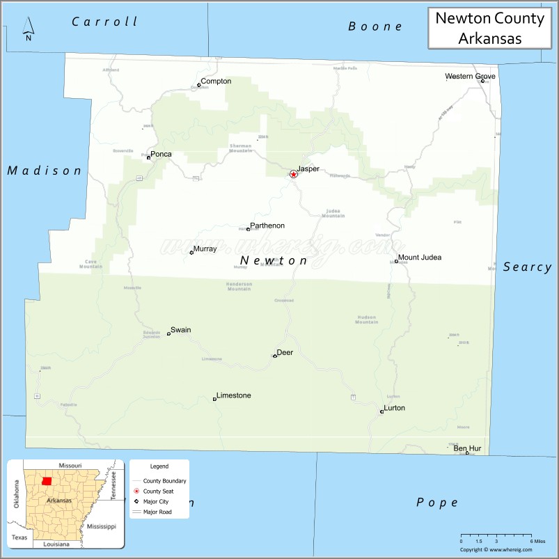
About Newton County Map, Arkansas: The map showing the county boundary, county seat, major cities, highways, water bodies and neighbouring counties.
Related Arkansas & US Links
Map of Newton County, Arkansas
Newton County is a county located in the U.S. state of Arkansas. It's county seat is Jasper. As per 2020 census, the population of Newton County is 7204 people and population density is square miles. According to the United States Census Bureau, the county has a total area of 823.18 sq mi (2,132 km2). Newton County was established on -20835.
Newton County Facts
| Continent | North America |
| Country | United States |
| State | Arkansas |
| County Seat | Jasper |
| Largest City/Town | Jasper |
| Established | December 14, 1842 |
| Total Area | 823 sq mi (2,131 sq km) |
| Land Area | 821 sq mi (2,126 sq km) |
| Water Area | 2 sq mi (5 sq km) |
| Population | 7,597 (Census 2020) |
| Population Density | 9.3 people per sq mi |
| Time Zone | Central Time Zone (CT) |
| Major Highways | AR 7, AR 16, AR 21, AR 43, AR 74 |
| Major Rivers | Buffalo River, Little Buffalo River |
| Neighboring Counties | Boone County, Searcy County, Pope County, Johnson County, Madison County, Carroll County |
| Famous For | Buffalo National River, Ozark Mountains, hiking, waterfalls, elk viewing |
| Top Attractions | Buffalo National River, Whitaker Point, Lost Valley Trail, Arkansas Grand Canyon |
| Official Website | Official Website |
About Newton County, Arkansas
Newton County is located in the northwestern part of Arkansas in the United States and was established in 1842. The county seat is Jasper, which is also the largest town in the county. The county lies within the Ozark Mountains and is widely known for its rugged scenery, limestone bluffs, waterfalls, forested valleys, and outdoor recreation along the Buffalo National River.
Cities and Towns in Newton County, Arkansas
| City/Town | Population (Census 2020) | Latitude & Longitude |
|---|---|---|
| Jasper (county seat) | 547 | 36.0087°N, 93.1860°W |
| Western Grove | 384 | 36.1037°N, 92.9535°W |
| Deer (CDP) | 103 | 35.8265°N, 93.2182°W |
| Marble Falls (CDP) | 135 | 36.1074°N, 93.0716°W |
| Parthenon (CDP) | 45 | 35.9643°N, 93.3008°W |
| Ponca (CDP) | 30 | 36.0067°N, 93.3652°W |
| Vendor (CDP) | 88 | 35.9584°N, 92.9897°W |
Golf Courses in Newton County, Arkansas
| Golf Course | Location | Latitude & Longitude |
|---|---|---|
| There are no major full-size golf courses currently operating within Newton County. | Newton County | 36.0000°N, 93.2000°W |
Roads and Highways in Newton County, Arkansas
Major highways connect the county to nearby mountain communities and recreation areas.
- Arkansas Highway 7 - scenic north-south route connecting Jasper with Harrison and Russellville
- Arkansas Highway 16 - east-west mountain highway linking communities across the Ozarks
- Arkansas Highway 21 - connects the county with Boxley Valley and southern Arkansas regions
- Arkansas Highway 43 - local route serving rural communities and Buffalo River access points
- Arkansas Highway 74 - scenic roadway connecting Jasper with Ponca and nearby recreation sites
What Are the Neighboring Counties of Newton County
- Boone County (north)
- Carroll County (northwest)
- Madison County (west)
- Johnson County (south)
- Pope County (southeast)
- Searcy County (east)
Whar Are the Top Attractions in Newton County, Arkansas
The county offers a mix of natural and cultural attractions.
- Buffalo National River - protected river known for floating, hiking, and towering limestone bluffs
- Whitaker Point (Hawksbill Crag) - famous rock formation and hiking destination with panoramic mountain views
- Lost Valley Trail - popular hiking trail featuring waterfalls, caves, and scenic forest landscapes
- Arkansas Grand Canyon - scenic overlook along Highway 7 with sweeping Ozark Mountain views
- Hemmed-In Hollow Falls - one of the tallest waterfalls between the Rockies and Appalachians
- Boxley Valley Historic District - historic valley known for elk viewing and old homesteads
- Ponca Elk Education Center - visitor center focused on the region's elk population and wildlife
- Steel Creek Campground - riverside camping area along the Buffalo National River
- Glory Hole Falls - unique waterfall flowing through a hole in an overhanging bluff
- Ozark National Forest - large forest area offering hiking, camping, and wildlife viewing opportunities
- Triple Falls - scenic waterfall area near Camp Orr popular with hikers
- Indian Creek Trail - hiking route with creek crossings and scenic bluff views
What is the Distance from Newton County to Nearby Cities
The following distances are measured by road (driving).
- Jasper to Harrison (Boone County), Arkansas - 34 mi (55 km)
- Jasper to Russellville (Pope County), Arkansas - 87 mi (140 km)
- Jasper to Fayetteville (Washington County), Arkansas - 71 mi (114 km)
- Jasper to Conway (Faulkner County), Arkansas - 115 mi (185 km)
- Jasper to Mountain Home (Baxter County), Arkansas - 77 mi (124 km)
- Jasper to Clarksville (Johnson County), Arkansas - 69 mi (111 km)
- Jasper to Marshall (Searcy County), Arkansas - 43 mi (69 km)
- Jasper to Bentonville (Benton County), Arkansas - 96 mi (154 km)
- Jasper to Springdale (Washington County), Arkansas - 77 mi (124 km)
- Jasper to Little Rock (Pulaski County), Arkansas - 145 mi (233 km)
- Jasper to Branson (Taney County), Missouri - 61 mi (98 km)
- Jasper to Mountain View (Stone County), Arkansas - 67 mi (108 km)
FAQs about Newton County
Newton County is located in northwestern Arkansas within the Ozark Mountains region of the United States.
Newton County had a population of 7,597 according to the 2020 United States Census.
Newton County is known for the Buffalo National River, mountain scenery, waterfalls, hiking trails, and outdoor recreation.
The major highways include Arkansas Highway 7, Arkansas Highway 16, Arkansas Highway 21, Arkansas Highway 43, and Arkansas Highway 74.
Newton County has limited golf facilities, with most visitors focusing on outdoor recreation, hiking, river activities, and scenic tourism.
References
- QuickFacts - U.S. Census Bureau
- United States Census Bureau
- United States Geological Survey (USGS)
- National Geodetic Survey
- Official County Website
- Arkansas County Map
- Ashley County Map
- Baxter County Map
- Benton County Map
- Boone County Map
- Bradley County Map
- Calhoun County Map
- Carroll County Map
- Chicot County Map
- Clark County Map
- Clay County Map
- Cleburne County Map
- Cleveland County Map
- Columbia County Map
- Conway County Map
- Craighead County Map
- Crawford County Map
- Crittenden County Map
- Cross County Map
- Dallas County Map
- Desha County Map
- Drew County Map
- Faulkner County Map
- Franklin County Map
- Fulton County Map
- Garland County Map
- Grant County Map
- Greene County Map
- Hempstead County Map
- Hot Spring County Map
- Howard County Map
- Independence County Map
- Izard County Map
- Jackson County Map
- Jefferson County Map
- Johnson County Map
- Lafayette County Map
- Lawrence County Map
- Lee County Map
- Lincoln County Map
- Little River County Map
- Logan County Map
- Lonoke County Map
- Madison County Map
- Marion County Map
- Miller County Map
- Mississippi County Map
- Monroe County Map
- Montgomery County Map
- Nevada County Map
- Newton County Map
- Ouachita County Map
- Perry County Map
- Phillips County Map
- Pike County Map
- Poinsett County Map
- Polk County Map
- Pope County Map
- Prairie County Map
- Pulaski County Map
- Randolph County Map
- St Francis County Map
- Saline County Map
- Scott County Map
- Searcy County Map
- Sebastian County Map
- Sevier County Map
- Sharp County Map
- Stone County Map
- Union County Map
- Van Buren County Map
- Washington County Map
- White County Map
- Woodruff County Map
- Yell County Map
- Alabama Counties
- Alaska boroughs
- Arizona Counties
- Arkansas Counties
- California County Map
- Colorado Counties
- Connecticut Counties
- Delaware Counties
- Florida County Map
- Georgia County Map
- Hawaii Counties
- Idaho Counties
- Illinois Counties
- Indiana Counties
- Iowa Counties
- Kansas Counties
- Kentucky Counties
- Louisiana Counties
- Maine Counties
- Maryland Counties
- Massachusetts Counties
- Michigan County Map
- Minnesota Counties
- Mississippi Counties
- Missouri Counties
- Montana Counties
- Nebraska Counties
- Nevada Counties
- New York Counties
- New Hampshire Counties
- New Jersey Counties
- New Mexico Counties
- North Carolina Counties
- North Dakota Counties
- Ohio County Map
- Oklahoma Counties
- Oregon Counties
- Pennsylvania Counties
- Rhode Island Counties
- South Carolina Counties
- South Dakota Counties
- Map of Tennessee
- Texas County Map
- Utah Counties
- Vermont Counties
- Virginia Counties
- Washington Counties
- West Virginia Counties
- Wisconsin Counties
- Wyoming Counties