Written and Fact-checked by Whereig Editors, Reviewed by Mukesh Kumar| Last Updated On: May 10, 2026
Map of Pulaski County - Pulaski County is a county located in the U.S. state of Arkansas. Pulaski County Map showing cities, highways, important places and water bodies. Get Where is Pulaski County located in the map, major cities in Pulaski county, population, areas, and places of interest.
Pulaski County Map, Arkansas
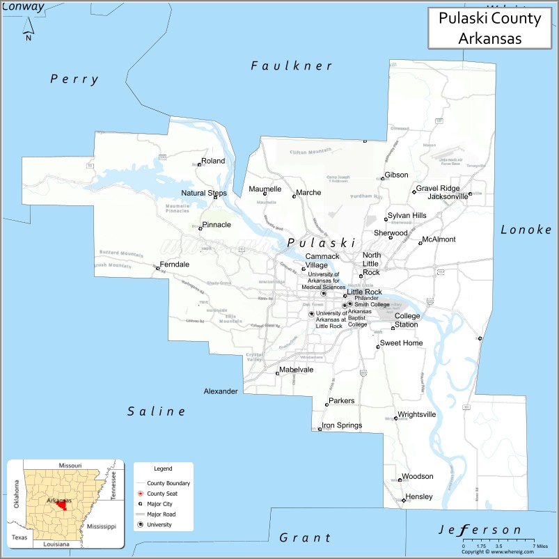
About Pulaski County Map, Arkansas: The map showing the county boundary, county seat, major cities, highways, water bodies and neighbouring counties.
Related Arkansas & US Links
Map of Pulaski County, Arkansas
Pulaski County is a county located in the U.S. state of Arkansas. It's county seat is Little Rock. As per 2020 census, the population of Pulaski County is 397821 people and population density is square miles. According to the United States Census Bureau, the county has a total area of 807.84 sq mi (2,092 km2). Pulaski County was established on -29600.
Pulaski County Facts
| Continent | North America |
| Country | United States |
| State | Arkansas |
| County Seat | Little Rock |
| Largest City/Town | Little Rock |
| Established | December 15, 1818 |
| Total Area | 808 sq mi (2,093 sq km) |
| Land Area | 760 sq mi (1,968 sq km) |
| Water Area | 48 sq mi (124 sq km) |
| Population | 399,125 (Census 2020) |
| Population Density | 525.2 people per sq mi |
| Time Zone | Central Time Zone (CT) |
| Major Highways | Interstate 30, Interstate 40, Interstate 430, Interstate 440, US 67, US 70, US 165, US 167 |
| Major Rivers | Arkansas River |
| Neighboring Counties | Faulkner County, Lonoke County, Saline County, Perry County, White County, Jefferson County |
| Famous For | Little Rock, Arkansas State Capitol, Clinton Presidential Center, Arkansas River |
| Top Attractions | Little Rock Central High School, River Market District, Pinnacle Mountain State Park, Clinton Presidential Library |
| Official Website | Official Website |
About Pulaski County, Arkansas
Pulaski County is located in central Arkansas in the United States and was established in 1818. The county seat is Little Rock, which is also the largest city in the county and the state capital of Arkansas. The county serves as the political, economic, and cultural center of Arkansas and features major urban districts, riverfront areas, parks, museums, and higher education institutions.
Cities and Towns in Pulaski County, Arkansas
| City/Town | Population (Census 2020) | Latitude & Longitude |
|---|---|---|
| Little Rock (county seat) | 202,591 | 34.7465°N, 92.2896°W |
| North Little Rock | 64,591 | 34.7695°N, 92.2671°W |
| Jacksonville | 29,477 | 34.8668°N, 92.1101°W |
| Sherwood | 32,731 | 34.8151°N, 92.2243°W |
| Maumelle | 19,251 | 34.8670°N, 92.4043°W |
| Wrightsville | 1,800 | 34.6023°N, 92.2182°W |
| Cammack Village | 778 | 34.7790°N, 92.3418°W |
| Alexander (partial) | 3,385 | 34.6295°N, 92.4413°W |
| College Station (CDP) | 455 | 34.6674°N, 92.2979°W |
| Sweet Home (CDP) | 849 | 34.6784°N, 92.2248°W |
Golf Courses in Pulaski County, Arkansas
| Golf Course | Location | Latitude & Longitude |
|---|---|---|
| Rebsamen Golf Course | Little Rock | 34.7785°N, 92.3157°W |
| War Memorial Golf Course | Little Rock | 34.7498°N, 92.3386°W |
| Country Club of Little Rock | Little Rock | 34.7540°N, 92.3491°W |
| Burns Park Golf Course | North Little Rock | 34.8014°N, 92.3379°W |
| Maumelle Country Club | Maumelle | 34.8648°N, 92.3988°W |
| The First Tee of Central Arkansas | Little Rock | 34.7241°N, 92.3197°W |
Roads and Highways in Pulaski County, Arkansas
Major highways connect the county to all regions of Arkansas and neighboring states.
- Interstate 30 - major interstate connecting Little Rock with Dallas and Memphis
- Interstate 40 - east-west interstate linking Pulaski County with Oklahoma and Tennessee
- Interstate 430 - western bypass route around Little Rock metropolitan areas
- Interstate 440 - southeastern bypass route connecting Interstate 30 and Interstate 40
- US Highway 67 - major north-south corridor through central Arkansas
- US Highway 70 - regional route serving urban and suburban communities
- US Highway 165 - connects southern Arkansas communities with Little Rock
- US Highway 167 - major route through central and northeastern Arkansas
What Are the Neighboring Counties of Pulaski County
- Faulkner County (north)
- White County (northeast)
- Lonoke County (east)
- Jefferson County (south)
- Saline County (southwest)
- Perry County (west)
Whar Are the Top Attractions in Pulaski County, Arkansas
The county offers a mix of natural and cultural attractions.
- Little Rock Central High School National Historic Site - landmark site of the Civil Rights Movement
- William J. Clinton Presidential Library and Museum - presidential museum and archives on the Arkansas River
- River Market District - downtown entertainment area with restaurants, shops, and cultural attractions
- Pinnacle Mountain State Park - popular hiking and outdoor recreation destination west of Little Rock
- Arkansas State Capitol - historic government building and major architectural landmark
- Big Dam Bridge - one of the longest pedestrian and bicycle bridges in North America
- Little Rock Zoo - family-friendly zoo with animals from around the world
- Museum of Discovery - science and technology museum with interactive exhibits
- Old State House Museum - historic museum focused on Arkansas political history
- Burns Park - one of the largest municipal parks in the United States
- Arkansas Inland Maritime Museum - museum featuring naval vessels and military exhibits
- Two Rivers Park - scenic park with trails and Arkansas River access
- Esse Purse Museum - unique museum dedicated to the history of handbags and fashion
- Wildwood Park for the Arts - cultural and performing arts park with gardens and trails
- Arkansas River Trail - extensive multi-use trail system along the riverfront
What is the Distance from Pulaski County to Nearby Cities
The following distances are measured by road (driving).
- Little Rock to Conway (Faulkner County), Arkansas - 32 mi (51 km)
- Little Rock to Pine Bluff (Jefferson County), Arkansas - 44 mi (71 km)
- Little Rock to Hot Springs (Garland County), Arkansas - 55 mi (89 km)
- Little Rock to Searcy (White County), Arkansas - 51 mi (82 km)
- Little Rock to Russellville (Pope County), Arkansas - 81 mi (130 km)
- Little Rock to Memphis (Shelby County), Tennessee - 137 mi (220 km)
- Little Rock to Fayetteville (Washington County), Arkansas - 190 mi (306 km)
- Little Rock to Jonesboro (Craighead County), Arkansas - 134 mi (216 km)
- Little Rock to Texarkana (Miller County), Arkansas - 143 mi (230 km)
- Little Rock to Fort Smith (Sebastian County), Arkansas - 159 mi (256 km)
- Little Rock to Benton (Saline County), Arkansas - 26 mi (42 km)
- Little Rock to Cabot (Lonoke County), Arkansas - 30 mi (48 km)
FAQs about Pulaski County
Pulaski County is located in central Arkansas and includes the state capital city of Little Rock.
Pulaski County had a population of 399,125 according to the 2020 United States Census.
Pulaski County is known for Little Rock, the Arkansas State Capitol, the Clinton Presidential Library, and major cultural attractions.
The major highways include Interstate 30, Interstate 40, Interstate 430, Interstate 440, US Highway 67, US Highway 70, US Highway 165, and US Highway 167.
Yes, Pulaski County has several golf facilities including Rebsamen Golf Course, Burns Park Golf Course, and Maumelle Country Club.
References
- QuickFacts - U.S. Census Bureau
- United States Census Bureau
- United States Geological Survey (USGS)
- National Geodetic Survey
- Official Website
- Arkansas County Map
- Ashley County Map
- Baxter County Map
- Benton County Map
- Boone County Map
- Bradley County Map
- Calhoun County Map
- Carroll County Map
- Chicot County Map
- Clark County Map
- Clay County Map
- Cleburne County Map
- Cleveland County Map
- Columbia County Map
- Conway County Map
- Craighead County Map
- Crawford County Map
- Crittenden County Map
- Cross County Map
- Dallas County Map
- Desha County Map
- Drew County Map
- Faulkner County Map
- Franklin County Map
- Fulton County Map
- Garland County Map
- Grant County Map
- Greene County Map
- Hempstead County Map
- Hot Spring County Map
- Howard County Map
- Independence County Map
- Izard County Map
- Jackson County Map
- Jefferson County Map
- Johnson County Map
- Lafayette County Map
- Lawrence County Map
- Lee County Map
- Lincoln County Map
- Little River County Map
- Logan County Map
- Lonoke County Map
- Madison County Map
- Marion County Map
- Miller County Map
- Mississippi County Map
- Monroe County Map
- Montgomery County Map
- Nevada County Map
- Newton County Map
- Ouachita County Map
- Perry County Map
- Phillips County Map
- Pike County Map
- Poinsett County Map
- Polk County Map
- Pope County Map
- Prairie County Map
- Pulaski County Map
- Randolph County Map
- St Francis County Map
- Saline County Map
- Scott County Map
- Searcy County Map
- Sebastian County Map
- Sevier County Map
- Sharp County Map
- Stone County Map
- Union County Map
- Van Buren County Map
- Washington County Map
- White County Map
- Woodruff County Map
- Yell County Map
- Alabama Counties
- Alaska boroughs
- Arizona Counties
- Arkansas Counties
- California County Map
- Colorado Counties
- Connecticut Counties
- Delaware Counties
- Florida County Map
- Georgia County Map
- Hawaii Counties
- Idaho Counties
- Illinois Counties
- Indiana Counties
- Iowa Counties
- Kansas Counties
- Kentucky Counties
- Louisiana Counties
- Maine Counties
- Maryland Counties
- Massachusetts Counties
- Michigan County Map
- Minnesota Counties
- Mississippi Counties
- Missouri Counties
- Montana Counties
- Nebraska Counties
- Nevada Counties
- New York Counties
- New Hampshire Counties
- New Jersey Counties
- New Mexico Counties
- North Carolina Counties
- North Dakota Counties
- Ohio County Map
- Oklahoma Counties
- Oregon Counties
- Pennsylvania Counties
- Rhode Island Counties
- South Carolina Counties
- South Dakota Counties
- Map of Tennessee
- Texas County Map
- Utah Counties
- Vermont Counties
- Virginia Counties
- Washington Counties
- West Virginia Counties
- Wisconsin Counties
- Wyoming Counties