Written and Fact-checked by Whereig Editors, Reviewed by Mukesh Kumar| Last Updated On: May 10, 2026
Map of Cleburne County - Cleburne County is a county located in the U.S. state of Arkansas. Cleburne County Map showing cities, highways, important places and water bodies. Get Where is Cleburne County located in the map, major cities in Cleburne county, population, areas, and places of interest.
Cleburne County Map, Arkansas
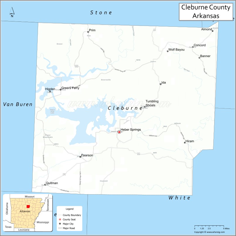
About Cleburne County Map, Arkansas: The map showing the county boundary, county seat, major cities, highways, water bodies and neighbouring counties.
Related Arkansas & US Links
Map of Cleburne County, Arkansas
Cleburne County is a county located in the U.S. state of Arkansas. It's county seat is Heber Springs. As per 2020 census, the population of Cleburne County is 25015 people and population density is square miles. According to the United States Census Bureau, the county has a total area of 591.91 sq mi (1,533 km2). Cleburne County was established on -6157.
Cleburne County Facts
| Continent | North America |
| Country | United States |
| State | Arkansas |
| County Seat | Heber Springs |
| Largest City/Town | Heber Springs |
| Established | 1883 |
| Total Area | 592 sq mi (1,533 sq km) |
| Land Area | 553 sq mi (1,432 sq km) |
| Water Area | 39 sq mi (101 sq km) |
| Population | 24,711 (Census 2020) |
| Population Density | 44.7 people per sq mi |
| Time Zone | Central Time Zone (CST/CDT) |
| Major Highways | US Highway 65, Arkansas Highway 25, Arkansas Highway 16 |
| Major Rivers | Little Red River, Greers Ferry Lake |
| Neighboring Counties | Stone County, Independence County, White County, Van Buren County, Faulkner County |
| Famous For | Greers Ferry Lake, trout fishing, Little Red River, and Ozark foothill recreation |
| Top Attractions | Greers Ferry Lake, Little Red River, Sugar Loaf Mountain, Heber Springs recreation areas |
| Official Website | Official Website |
About Cleburne County, Arkansas
Cleburne County is located in north-central Arkansas in the United States and was established in 1883. The county seat and largest city is Heber Springs. Cleburne County is known for Greers Ferry Lake, trout fishing on the Little Red River, boating, hiking, and scenic Ozark foothill landscapes.
Cities and Towns in Cleburne County, Arkansas
| City/Town | Population (Census 2020) | Latitude & Longitude |
|---|---|---|
| Heber Springs (county seat) | 6,969 | 35.4915°N, 92.0335°W |
| Greers Ferry | 891 | 35.5770°N, 92.1779°W |
| Quitman | 762 | 35.3812°N, 92.2151°W |
| Concord | 244 | 35.6626°N, 91.8468°W |
| Higden | 114 | 35.5651°N, 92.2048°W |
| Wilburn | Small rural community | 35.5084°N, 91.9315°W |
| Greers Ferry Lake region | Outdoor recreation area | 35.5800°N, 92.1500°W |
| Ozark foothills region | Scenic upland landscape | 35.5000°N, 92.0500°W |
Golf Courses in Cleburne County, Arkansas
| Golf Course | Location | Latitude & Longitude |
|---|---|---|
| Eden Isle Golf Course | Greers Ferry | 35.5775°N, 92.1628°W |
| Indian Hills Golf Resort | Fairfield Bay nearby | 35.6008°N, 92.2799°W |
| Red Apple Inn & Country Club | Heber Springs | 35.5488°N, 92.0971°W |
Roads and Highways in Cleburne County, Arkansas
Major highways connect the county to central Arkansas, the Ozarks, and Greers Ferry Lake recreation regions.
- US Highway 65 - north-south highway connecting the county with Conway and northern Arkansas
- Arkansas Highway 25 - scenic route serving Greers Ferry Lake and surrounding communities
- Arkansas Highway 16 - east-west highway linking Heber Springs with mountain recreation areas
What Are the Neighboring Counties of Cleburne County
- Stone County (north)
- Independence County (east)
- White County (southeast)
- Van Buren County (west)
- Faulkner County (southwest)
Whar Are the Top Attractions in Cleburne County, Arkansas
The county offers a mix of lake recreation, trout fishing, and scenic Ozark foothill attractions.
- Greers Ferry Lake - boating, swimming, fishing, and camping destination
- Little Red River - internationally known trout fishing stream
- Sugar Loaf Mountain Island - hiking trails and scenic lake views
- Heber Springs recreation areas - marinas, parks, and lakeside activities
- Dam Site Recreation Area - picnic spots, beaches, and boating access
- Greers Ferry Dam - engineering landmark and scenic overlook area
- Ozark foothill scenic drives - panoramic views and outdoor recreation routes
- Cow Shoals recreation area - swimming and family outdoor activities
- John F. Kennedy Memorial Overlook - historic viewpoint above the lake
- Fishing and camping resorts around Greers Ferry Lake - vacation and outdoor recreation facilities
- Local festivals and lake events - community celebrations and seasonal activities
- Wildlife viewing and birdwatching areas - forest and lakeside nature habitats
What is the Distance from Cleburne County to Nearby Cities
The following distances are measured by road (driving).
- Heber Springs to Conway (Faulkner County), Arkansas - 53 mi (85 km)
- Heber Springs to Batesville (Independence County), Arkansas - 48 mi (77 km)
- Heber Springs to Little Rock (Pulaski County), Arkansas - 70 mi (113 km)
- Heber Springs to Mountain View (Stone County), Arkansas - 50 mi (80 km)
- Heber Springs to Jonesboro (Craighead County), Arkansas - 112 mi (180 km)
- Heber Springs to Hot Springs (Garland County), Arkansas - 101 mi (163 km)
- Heber Springs to Memphis (Shelby County), Tennessee - 150 mi (241 km)
- Heber Springs to Springfield (Greene County), Missouri - 196 mi (315 km)
- Heber Springs to Tulsa (Tulsa County), Oklahoma - 260 mi (418 km)
- Heber Springs to St. Louis (St. Louis City), Missouri - 337 mi (542 km)
- Heber Springs to Nashville (Davidson County), Tennessee - 344 mi (554 km)
- Heber Springs to Dallas (Dallas County), Texas - 390 mi (628 km)
FAQs about Cleburne County
Cleburne County is located in north-central Arkansas in the United States.
The population of Cleburne County was 24,711 according to the Census 2020.
Cleburne County is known for Greers Ferry Lake, Little Red River trout fishing, and Ozark foothill recreation.
The county is served by US Highway 65, Arkansas Highway 25, and Arkansas Highway 16.
Popular attractions include Greers Ferry Lake, Little Red River, Sugar Loaf Mountain, and Heber Springs recreation areas.
References
- QuickFacts - U.S. Census Bureau
- United States Census Bureau
- United States Geological Survey (USGS)
- National Geodetic Survey
- Official Website
- Arkansas County Map
- Ashley County Map
- Baxter County Map
- Benton County Map
- Boone County Map
- Bradley County Map
- Calhoun County Map
- Carroll County Map
- Chicot County Map
- Clark County Map
- Clay County Map
- Cleburne County Map
- Cleveland County Map
- Columbia County Map
- Conway County Map
- Craighead County Map
- Crawford County Map
- Crittenden County Map
- Cross County Map
- Dallas County Map
- Desha County Map
- Drew County Map
- Faulkner County Map
- Franklin County Map
- Fulton County Map
- Garland County Map
- Grant County Map
- Greene County Map
- Hempstead County Map
- Hot Spring County Map
- Howard County Map
- Independence County Map
- Izard County Map
- Jackson County Map
- Jefferson County Map
- Johnson County Map
- Lafayette County Map
- Lawrence County Map
- Lee County Map
- Lincoln County Map
- Little River County Map
- Logan County Map
- Lonoke County Map
- Madison County Map
- Marion County Map
- Miller County Map
- Mississippi County Map
- Monroe County Map
- Montgomery County Map
- Nevada County Map
- Newton County Map
- Ouachita County Map
- Perry County Map
- Phillips County Map
- Pike County Map
- Poinsett County Map
- Polk County Map
- Pope County Map
- Prairie County Map
- Pulaski County Map
- Randolph County Map
- St Francis County Map
- Saline County Map
- Scott County Map
- Searcy County Map
- Sebastian County Map
- Sevier County Map
- Sharp County Map
- Stone County Map
- Union County Map
- Van Buren County Map
- Washington County Map
- White County Map
- Woodruff County Map
- Yell County Map
- Alabama Counties
- Alaska boroughs
- Arizona Counties
- Arkansas Counties
- California County Map
- Colorado Counties
- Connecticut Counties
- Delaware Counties
- Florida County Map
- Georgia County Map
- Hawaii Counties
- Idaho Counties
- Illinois Counties
- Indiana Counties
- Iowa Counties
- Kansas Counties
- Kentucky Counties
- Louisiana Counties
- Maine Counties
- Maryland Counties
- Massachusetts Counties
- Michigan County Map
- Minnesota Counties
- Mississippi Counties
- Missouri Counties
- Montana Counties
- Nebraska Counties
- Nevada Counties
- New York Counties
- New Hampshire Counties
- New Jersey Counties
- New Mexico Counties
- North Carolina Counties
- North Dakota Counties
- Ohio County Map
- Oklahoma Counties
- Oregon Counties
- Pennsylvania Counties
- Rhode Island Counties
- South Carolina Counties
- South Dakota Counties
- Map of Tennessee
- Texas County Map
- Utah Counties
- Vermont Counties
- Virginia Counties
- Washington Counties
- West Virginia Counties
- Wisconsin Counties
- Wyoming Counties