Written and Fact-checked by Whereig Editors, Reviewed by Mukesh Kumar| Last Updated On: May 10, 2026
Map of Lafayette County - Lafayette County is a county located in the U.S. state of Arkansas. Lafayette County Map showing cities, highways, important places and water bodies. Get Where is Lafayette County located in the map, major cities in Lafayette county, population, areas, and places of interest.
Lafayette County Map, Arkansas
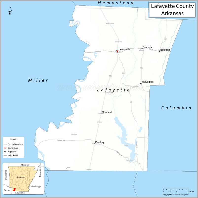
About Lafayette County Map, Arkansas: The map showing the county boundary, county seat, major cities, highways, water bodies and neighbouring counties.
Related Arkansas & US Links
Map of Lafayette County, Arkansas
Lafayette County is a county located in the U.S. state of Arkansas. It's county seat is Lewisville. As per 2020 census, the population of Lafayette County is 6163 people and population density is square miles. According to the United States Census Bureau, the county has a total area of 545.07 sq mi (1,412 km2). Lafayette County was established on -26374.
Lafayette County Facts
| Continent | North America |
| Country | United States |
| State | Arkansas |
| County Seat | Lewisville |
| Largest City/Town | Stamps |
| Established | 1827 |
| Total Area | 545 sq mi (1,412 sq km) |
| Land Area | 528 sq mi (1,368 sq km) |
| Water Area | 17 sq mi (44 sq km) |
| Population | 6,308 (Census 2020) |
| Population Density | 11.9 people per sq mi |
| Time Zone | Central Time Zone (CST/CDT) |
| Major Highways | US Highway 82, Arkansas Highway 29, Arkansas Highway 53 |
| Major Rivers | Red River, Bodcau Creek |
| Neighboring Counties | Columbia County, Hempstead County, Miller County, Nevada County, Bowie County (TX) |
| Famous For | Delta agriculture, timberlands, blues heritage, and rural southwest Arkansas culture |
| Top Attractions | Lafayette County Courthouse, Historic Stamps downtown, Red River recreation, nearby Poison Springs Battleground State Park |
| Official Website | Official Website |
About Lafayette County, Arkansas
Lafayette County is located in southwestern Arkansas in the United States and was established in 1827. The county seat is Lewisville, while Stamps is the largest city. Lafayette County is known for its agricultural economy, timber production, Delta and blues heritage, and quiet rural communities near the Texas border.
Cities and Towns in Lafayette County, Arkansas
| City/Town | Population (Census 2020) | Latitude & Longitude |
|---|---|---|
| Stamps | 1,258 | 33.3651°N, 93.4957°W |
| Lewisville (county seat) | 915 | 33.3570°N, 93.5774°W |
| Bradley | 563 | 33.0996°N, 93.6549°W |
| Buckner | 252 | 33.3585°N, 93.5527°W |
| Garland City | 349 | 33.3610°N, 93.7094°W |
| Lewisville Lake region | Outdoor recreation area | 33.3400°N, 93.5700°W |
| Red River region | River landscape area | 33.2000°N, 93.7000°W |
| Southwest Arkansas timber region | Forest landscape area | 33.3000°N, 93.6000°W |
Golf Courses in Lafayette County, Arkansas
| Golf Course | Location | Latitude & Longitude |
|---|---|---|
| Magnolia Country Club | Magnolia nearby | 33.2664°N, 93.2390°W |
| Texarkana Country Club | Texarkana nearby | 33.4760°N, 94.0521°W |
| Hope Country Club | Hope nearby | 33.6718°N, 93.6004°W |
Roads and Highways in Lafayette County, Arkansas
Major highways connect the county to Texarkana, southern Arkansas, and nearby Texas communities.
- US Highway 82 - major east-west route across southern Arkansas
- Arkansas Highway 29 - regional north-south highway through timber and agricultural regions
- Arkansas Highway 53 - local transportation route linking rural communities
What Are the Neighboring Counties of Lafayette County
- Columbia County (east)
- Hempstead County (north)
- Miller County (west)
- Nevada County (northeast)
- Bowie County, Texas (southwest)
Whar Are the Top Attractions in Lafayette County, Arkansas
The county offers a mix of historical landmarks, river recreation, and scenic rural landscapes.
- Historic downtown Stamps - local shops, heritage buildings, and community events
- Lafayette County Courthouse - historic architecture and county landmark
- Red River recreation areas - fishing, boating, and outdoor activities
- Lewisville Lake recreation - camping, fishing, and family outdoor recreation
- Nearby Poison Springs Battleground State Park - Civil War history and nature trails
- Southwest Arkansas scenic drives - timberlands, farmland, and countryside views
- Community festivals and county fairs - celebrations of local traditions and culture
- Historic churches and rural heritage sites - architecture and regional history
- Wildlife observation and birdwatching areas - wetlands and forest habitats
- Fishing lakes and picnic areas throughout the county - family recreation destinations
- Regional blues and Delta culture heritage - music history and traditions
- Nearby Texarkana attractions access - shopping, dining, and entertainment opportunities
What is the Distance from Lafayette County to Nearby Cities
The following distances are measured by road (driving).
- Lewisville to Texarkana (Miller County), Arkansas - 34 mi (55 km)
- Lewisville to Hope (Hempstead County), Arkansas - 39 mi (63 km)
- Lewisville to Magnolia (Columbia County), Arkansas - 31 mi (50 km)
- Lewisville to Shreveport (Caddo Parish), Louisiana - 86 mi (138 km)
- Lewisville to Little Rock (Pulaski County), Arkansas - 143 mi (230 km)
- Lewisville to Dallas (Dallas County), Texas - 186 mi (299 km)
- Lewisville to Monroe (Ouachita Parish), Louisiana - 123 mi (198 km)
- Lewisville to Jackson (Hinds County), Mississippi - 239 mi (385 km)
- Lewisville to Oklahoma City (Oklahoma County), Oklahoma - 292 mi (470 km)
- Lewisville to Tulsa (Tulsa County), Oklahoma - 275 mi (443 km)
- Lewisville to Memphis (Shelby County), Tennessee - 258 mi (415 km)
- Lewisville to New Orleans (Orleans Parish), Louisiana - 394 mi (634 km)
FAQs about Lafayette County
Lafayette County is located in southwestern Arkansas near the Texas border in the United States.
The population of Lafayette County was 6,308 according to the Census 2020.
Lafayette County is known for agriculture, timberlands, Delta culture, and rural southwest Arkansas heritage.
The county is served by US Highway 82, Arkansas Highway 29, and Arkansas Highway 53.
Popular attractions include Historic Stamps downtown, the Lafayette County Courthouse, Red River recreation areas, and nearby Poison Springs Battleground State Park.
References
- QuickFacts - U.S. Census Bureau
- United States Census Bureau
- United States Geological Survey (USGS)
- National Geodetic Survey
- Official Website
- Arkansas County Map
- Ashley County Map
- Baxter County Map
- Benton County Map
- Boone County Map
- Bradley County Map
- Calhoun County Map
- Carroll County Map
- Chicot County Map
- Clark County Map
- Clay County Map
- Cleburne County Map
- Cleveland County Map
- Columbia County Map
- Conway County Map
- Craighead County Map
- Crawford County Map
- Crittenden County Map
- Cross County Map
- Dallas County Map
- Desha County Map
- Drew County Map
- Faulkner County Map
- Franklin County Map
- Fulton County Map
- Garland County Map
- Grant County Map
- Greene County Map
- Hempstead County Map
- Hot Spring County Map
- Howard County Map
- Independence County Map
- Izard County Map
- Jackson County Map
- Jefferson County Map
- Johnson County Map
- Lafayette County Map
- Lawrence County Map
- Lee County Map
- Lincoln County Map
- Little River County Map
- Logan County Map
- Lonoke County Map
- Madison County Map
- Marion County Map
- Miller County Map
- Mississippi County Map
- Monroe County Map
- Montgomery County Map
- Nevada County Map
- Newton County Map
- Ouachita County Map
- Perry County Map
- Phillips County Map
- Pike County Map
- Poinsett County Map
- Polk County Map
- Pope County Map
- Prairie County Map
- Pulaski County Map
- Randolph County Map
- St Francis County Map
- Saline County Map
- Scott County Map
- Searcy County Map
- Sebastian County Map
- Sevier County Map
- Sharp County Map
- Stone County Map
- Union County Map
- Van Buren County Map
- Washington County Map
- White County Map
- Woodruff County Map
- Yell County Map
- Alabama Counties
- Alaska boroughs
- Arizona Counties
- Arkansas Counties
- California County Map
- Colorado Counties
- Connecticut Counties
- Delaware Counties
- Florida County Map
- Georgia County Map
- Hawaii Counties
- Idaho Counties
- Illinois Counties
- Indiana Counties
- Iowa Counties
- Kansas Counties
- Kentucky Counties
- Louisiana Counties
- Maine Counties
- Maryland Counties
- Massachusetts Counties
- Michigan County Map
- Minnesota Counties
- Mississippi Counties
- Missouri Counties
- Montana Counties
- Nebraska Counties
- Nevada Counties
- New York Counties
- New Hampshire Counties
- New Jersey Counties
- New Mexico Counties
- North Carolina Counties
- North Dakota Counties
- Ohio County Map
- Oklahoma Counties
- Oregon Counties
- Pennsylvania Counties
- Rhode Island Counties
- South Carolina Counties
- South Dakota Counties
- Map of Tennessee
- Texas County Map
- Utah Counties
- Vermont Counties
- Virginia Counties
- Washington Counties
- West Virginia Counties
- Wisconsin Counties
- Wyoming Counties