Written and Fact-checked by Whereig Editors, Reviewed by Mukesh Kumar| Last Updated On: May 10, 2026
Map of Greene County - Greene County is a county located in the U.S. state of Arkansas. Greene County Map showing cities, highways, important places and water bodies. Get Where is Greene County located in the map, major cities in Greene county, population, areas, and places of interest.
Greene County Map, Arkansas
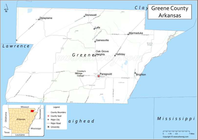
About Greene County Map, Arkansas: The map showing the county boundary, county seat, major cities, highways, water bodies and neighbouring counties.
Related Arkansas & US Links
Map of Greene County, Arkansas
Greene County is a county located in the U.S. state of Arkansas. It's county seat is Paragould. As per 2020 census, the population of Greene County is 46317 people and population density is square miles. According to the United States Census Bureau, the county has a total area of 579.65 sq mi (1,501 km2). Greene County was established on -24161.
Greene County Facts
| Continent | North America |
| Country | United States |
| State | Arkansas |
| County Seat | Paragould |
| Largest City/Town | Paragould |
| Established | 1833 |
| Total Area | 578 sq mi (1,497 sq km) |
| Land Area | 577 sq mi (1,494 sq km) |
| Water Area | 1 sq mi (3 sq km) |
| Population | 45,736 (Census 2020) |
| Population Density | 79.3 people per sq mi |
| Time Zone | Central Time Zone (CST/CDT) |
| Major Highways | US Highway 49, US Highway 412, Arkansas Highway 135 |
| Major Rivers | St. Francis River, Cache River watershed |
| Neighboring Counties | Clay County, Craighead County, Lawrence County, Randolph County, Dunklin County (MO) |
| Famous For | Paragould, Crowley’s Ridge landscapes, agriculture, and manufacturing industries |
| Top Attractions | Crowley’s Ridge State Park nearby, Downtown Paragould, Lake Frierson recreation nearby, Collins Theatre |
| Official Website | Official Website |
About Greene County, Arkansas
Greene County is located in northeastern Arkansas in the United States and was established in 1833. The county seat and largest city is Paragould. Greene County is known for agriculture, manufacturing, Crowley’s Ridge scenery, and its role as an economic center near the Missouri border.
Cities and Towns in Greene County, Arkansas
| City/Town | Population (Census 2020) | Latitude & Longitude |
|---|---|---|
| Paragould (county seat) | 29,537 | 36.0584°N, 90.4973°W |
| Marmaduke | 1,111 | 36.1876°N, 90.3834°W |
| Lafe | 458 | 36.2048°N, 90.5095°W |
| Oak Grove Heights | 1,104 | 36.1254°N, 90.5137°W |
| Delaplaine | 116 | 36.2320°N, 90.7215°W |
| Walcott | Rural community | 35.9704°N, 90.6648°W |
| Crowley’s Ridge region | Scenic ridge landscape area | 36.0500°N, 90.5000°W |
| Northeast Arkansas farmland region | Agricultural landscape area | 36.1000°N, 90.5000°W |
Golf Courses in Greene County, Arkansas
| Golf Course | Location | Latitude & Longitude |
|---|---|---|
| Greene County Country Club | Paragould | 36.0604°N, 90.5008°W |
| Paragould Country Club | Paragould | 36.0538°N, 90.4942°W |
| Sage Meadows Country Club | Jonesboro nearby | 35.8851°N, 90.6625°W |
Roads and Highways in Greene County, Arkansas
Major highways connect the county to Missouri, Jonesboro, and northeastern Arkansas agricultural regions.
- US Highway 49 - major north-south highway linking Paragould with Jonesboro and Missouri
- US Highway 412 - east-west route through northeastern Arkansas and the Ozarks
- Arkansas Highway 135 - regional route serving rural communities and farmland areas
What Are the Neighboring Counties of Greene County
- Clay County (north)
- Craighead County (south)
- Lawrence County (west)
- Randolph County (northwest)
- Dunklin County, Missouri (east)
Whar Are the Top Attractions in Greene County, Arkansas
The county offers a mix of cultural attractions, scenic landscapes, and outdoor recreation.
- Historic Downtown Paragould - restaurants, shopping, murals, and community events
- Collins Theatre - restored historic theater hosting performances and concerts
- Crowley’s Ridge scenic areas - rolling hills, forests, and photography opportunities
- Crowley’s Ridge State Park nearby - hiking, camping, and lake recreation
- Lake Frierson recreation nearby - fishing, boating, and outdoor activities
- Paragould community parks and trails - family recreation and sports facilities
- Agricultural heritage landscapes - scenic farmland drives and rural Arkansas culture
- Historic churches and courthouse district - architectural landmarks and local history
- Community festivals and county fairs - celebrations of northeastern Arkansas traditions
- Birdwatching and wildlife observation areas - wetlands and forest habitats
- Nearby Jonesboro attractions access - shopping, entertainment, and university events
- Nature photography and outdoor recreation routes - countryside and ridge scenery
What is the Distance from Greene County to Nearby Cities
The following distances are measured by road (driving).
- Paragould to Jonesboro (Craighead County), Arkansas - 20 mi (32 km)
- Paragould to Blytheville (Mississippi County), Arkansas - 55 mi (89 km)
- Paragould to Memphis (Shelby County), Tennessee - 82 mi (132 km)
- Paragould to Batesville (Independence County), Arkansas - 96 mi (154 km)
- Paragould to Springfield (Greene County), Missouri - 207 mi (333 km)
- Paragould to Little Rock (Pulaski County), Arkansas - 145 mi (233 km)
- Paragould to St. Louis (St. Louis City), Missouri - 256 mi (412 km)
- Paragould to Nashville (Davidson County), Tennessee - 260 mi (418 km)
- Paragould to Tulsa (Tulsa County), Oklahoma - 313 mi (504 km)
- Paragould to Kansas City (Jackson County), Missouri - 390 mi (628 km)
- Paragould to Dallas (Dallas County), Texas - 470 mi (756 km)
- Paragould to Birmingham (Jefferson County), Alabama - 331 mi (533 km)
FAQs about Greene County
Greene County is located in northeastern Arkansas near the Missouri border in the United States.
The population of Greene County was 45,736 according to the Census 2020.
Greene County is known for Paragould, Crowley’s Ridge scenery, agriculture, and manufacturing industries.
The county is served by US Highway 49, US Highway 412, and Arkansas Highway 135.
Popular attractions include Downtown Paragould, Crowley’s Ridge State Park nearby, Collins Theatre, and Lake Frierson recreation areas.
References
- QuickFacts - U.S. Census Bureau
- United States Census Bureau
- United States Geological Survey (USGS)
- National Geodetic Survey
- Official Website
- Arkansas County Map
- Ashley County Map
- Baxter County Map
- Benton County Map
- Boone County Map
- Bradley County Map
- Calhoun County Map
- Carroll County Map
- Chicot County Map
- Clark County Map
- Clay County Map
- Cleburne County Map
- Cleveland County Map
- Columbia County Map
- Conway County Map
- Craighead County Map
- Crawford County Map
- Crittenden County Map
- Cross County Map
- Dallas County Map
- Desha County Map
- Drew County Map
- Faulkner County Map
- Franklin County Map
- Fulton County Map
- Garland County Map
- Grant County Map
- Greene County Map
- Hempstead County Map
- Hot Spring County Map
- Howard County Map
- Independence County Map
- Izard County Map
- Jackson County Map
- Jefferson County Map
- Johnson County Map
- Lafayette County Map
- Lawrence County Map
- Lee County Map
- Lincoln County Map
- Little River County Map
- Logan County Map
- Lonoke County Map
- Madison County Map
- Marion County Map
- Miller County Map
- Mississippi County Map
- Monroe County Map
- Montgomery County Map
- Nevada County Map
- Newton County Map
- Ouachita County Map
- Perry County Map
- Phillips County Map
- Pike County Map
- Poinsett County Map
- Polk County Map
- Pope County Map
- Prairie County Map
- Pulaski County Map
- Randolph County Map
- St Francis County Map
- Saline County Map
- Scott County Map
- Searcy County Map
- Sebastian County Map
- Sevier County Map
- Sharp County Map
- Stone County Map
- Union County Map
- Van Buren County Map
- Washington County Map
- White County Map
- Woodruff County Map
- Yell County Map
- Alabama Counties
- Alaska boroughs
- Arizona Counties
- Arkansas Counties
- California County Map
- Colorado Counties
- Connecticut Counties
- Delaware Counties
- Florida County Map
- Georgia County Map
- Hawaii Counties
- Idaho Counties
- Illinois Counties
- Indiana Counties
- Iowa Counties
- Kansas Counties
- Kentucky Counties
- Louisiana Counties
- Maine Counties
- Maryland Counties
- Massachusetts Counties
- Michigan County Map
- Minnesota Counties
- Mississippi Counties
- Missouri Counties
- Montana Counties
- Nebraska Counties
- Nevada Counties
- New York Counties
- New Hampshire Counties
- New Jersey Counties
- New Mexico Counties
- North Carolina Counties
- North Dakota Counties
- Ohio County Map
- Oklahoma Counties
- Oregon Counties
- Pennsylvania Counties
- Rhode Island Counties
- South Carolina Counties
- South Dakota Counties
- Map of Tennessee
- Texas County Map
- Utah Counties
- Vermont Counties
- Virginia Counties
- Washington Counties
- West Virginia Counties
- Wisconsin Counties
- Wyoming Counties