Written and Fact-checked by Whereig Editors, Reviewed by Mukesh Kumar| Last Updated On: May 10, 2026
Map of Logan County - Logan County is a county located in the U.S. state of Arkansas. Logan County Map showing cities, highways, important places and water bodies. Get Where is Logan County located in the map, major cities in Logan county, population, areas, and places of interest.
Logan County Map, Arkansas
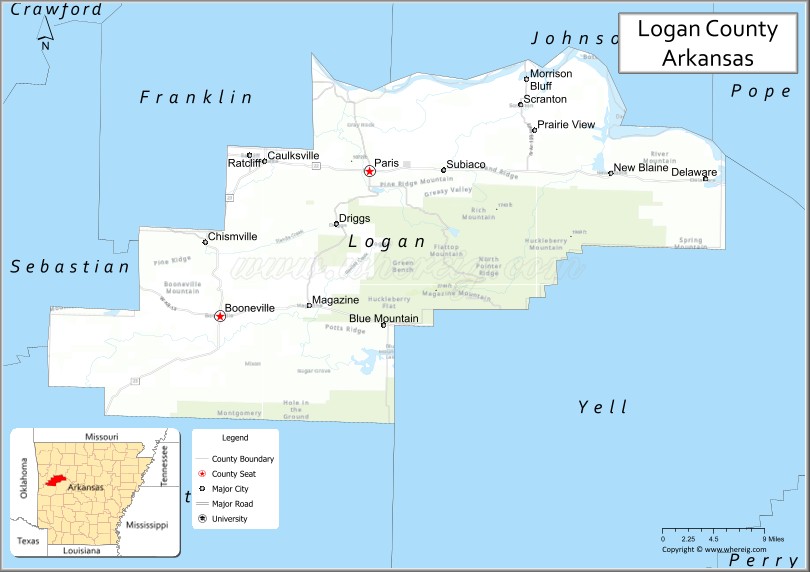
About Logan County Map, Arkansas: The map showing the county boundary, county seat, major cities, highways, water bodies and neighbouring counties.
Related Arkansas & US Links
Map of Logan County, Arkansas
"Logan County is a county located in the U.S. state of Arkansas. It's county seat is Booneville, Paris. As per 2020 census, the population of Logan County is 21215 people and population density is square miles. According to the United States Census Bureau, the county has a total area of 731.50 sq mi (1,895 km2). Logan County was established on -10510."
Logan County Facts
| Continent | North America |
| Country | United States |
| State | Arkansas |
| County Seat | Paris and Booneville |
| Largest City/Town | Booneville |
| Established | 1875 |
| Total Area | 732 sq mi (1,896 sq km) |
| Land Area | 708 sq mi (1,834 sq km) |
| Water Area | 24 sq mi (62 sq km) |
| Population | 21,131 (Census 2020) |
| Population Density | 29.8 people per sq mi |
| Time Zone | Central Time Zone (CST/CDT) |
| Major Highways | US Highway 64, Arkansas Highway 22, Arkansas Highway 23 |
| Major Rivers | Arkansas River, Petit Jean River |
| Neighboring Counties | Franklin County, Johnson County, Pope County, Scott County, Sebastian County, Yell County |
| Famous For | Mount Magazine, Arkansas wine country, scenic mountain landscapes, and outdoor recreation |
| Top Attractions | Mount Magazine State Park, Subiaco Abbey, Blue Mountain Lake, Paris town square |
| Official Website | Official Website |
About Logan County, Arkansas
Logan County is located in western Arkansas in the United States and was established in 1875. The county has two county seats, Paris and Booneville. Logan County is known for Mount Magazine, Arkansas wine country, mountain scenery, and outdoor recreation opportunities throughout the Arkansas River Valley region.
Cities and Towns in Logan County, Arkansas
| City/Town | Population (Census 2020) | Latitude & Longitude |
|---|---|---|
| Booneville | 3,633 | 35.1401°N, 93.9213°W |
| Paris | 3,176 | 35.2920°N, 93.7299°W |
| Magazine | 740 | 35.1709°N, 93.8052°W |
| Scranton | 224 | 35.3617°N, 93.5360°W |
| Blue Mountain | 124 | 35.1590°N, 93.6779°W |
| Subiaco | 401 | 35.2928°N, 93.6457°W |
| Mount Magazine region | Mountain recreation area | 35.1700°N, 93.6400°W |
| Arkansas River Valley region | Scenic landscape area | 35.2000°N, 93.7500°W |
Golf Courses in Logan County, Arkansas
| Golf Course | Location | Latitude & Longitude |
|---|---|---|
| Paris Country Club | Paris | 35.2928°N, 93.7341°W |
| Booneville Golf Club | Booneville | 35.1416°N, 93.9250°W |
| Chamberlyne Country Club | Danville nearby | 35.0538°N, 93.3934°W |
Roads and Highways in Logan County, Arkansas
Major highways connect the county to Fort Smith, the Ozark Mountains, and central Arkansas.
- US Highway 64 - historic east-west transportation route through the Arkansas River Valley
- Arkansas Highway 22 - scenic highway linking Paris, Booneville, and nearby mountain communities
- Arkansas Highway 23 - mountain route known for scenic drives and outdoor tourism access
What Are the Neighboring Counties of Logan County
- Franklin County (northwest)
- Johnson County (north)
- Pope County (east)
- Scott County (southwest)
- Sebastian County (west)
- Yell County (southeast)
Whar Are the Top Attractions in Logan County, Arkansas
The county offers a mix of mountain recreation, historic landmarks, and scenic countryside attractions.
- Mount Magazine State Park - Arkansas’ highest mountain with hiking, overlooks, and lodge accommodations
- Subiaco Abbey - historic Benedictine monastery and architectural landmark
- Blue Mountain Lake - boating, fishing, camping, and outdoor recreation
- Historic downtown Paris - local restaurants, shops, and community events
- Arkansas wine country vineyards - wineries and scenic countryside experiences
- Booneville downtown district - museums, heritage buildings, and local culture
- Ozark and Ouachita mountain scenic drives - panoramic landscapes and photography opportunities
- Hiking and camping trails throughout the county - nature recreation and wildlife viewing
- Community festivals and county fairs - celebrations of Arkansas traditions and agriculture
- Petit Jean River recreation areas - fishing, kayaking, and picnic destinations
- Nature trails and birdwatching sites - forest and mountain habitats
- Historic churches and courthouse districts - architecture and regional history
What is the Distance from Logan County to Nearby Cities
The following distances are measured by road (driving).
- Paris to Fort Smith (Sebastian County), Arkansas - 47 mi (76 km)
- Paris to Russellville (Pope County), Arkansas - 44 mi (71 km)
- Paris to Fayetteville (Washington County), Arkansas - 95 mi (153 km)
- Paris to Little Rock (Pulaski County), Arkansas - 112 mi (180 km)
- Paris to Tulsa (Tulsa County), Oklahoma - 139 mi (224 km)
- Paris to Springfield (Greene County), Missouri - 176 mi (283 km)
- Paris to Oklahoma City (Oklahoma County), Oklahoma - 228 mi (367 km)
- Paris to Kansas City (Jackson County), Missouri - 303 mi (488 km)
- Paris to Memphis (Shelby County), Tennessee - 254 mi (409 km)
- Paris to Dallas (Dallas County), Texas - 319 mi (513 km)
- Paris to St. Louis (St. Louis City), Missouri - 365 mi (587 km)
- Paris to Nashville (Davidson County), Tennessee - 450 mi (724 km)
FAQs about Logan County
Logan County is located in western Arkansas in the United States.
The population of Logan County was 21,131 according to the Census 2020.
Logan County is known for Mount Magazine, Arkansas wine country, scenic mountain landscapes, and outdoor recreation.
The county is served by US Highway 64, Arkansas Highway 22, and Arkansas Highway 23.
Popular attractions include Mount Magazine State Park, Subiaco Abbey, Blue Mountain Lake, and historic downtown Paris.
References
- QuickFacts - U.S. Census Bureau
- United States Census Bureau
- United States Geological Survey (USGS)
- National Geodetic Survey
- Official Website
- Arkansas County Map
- Ashley County Map
- Baxter County Map
- Benton County Map
- Boone County Map
- Bradley County Map
- Calhoun County Map
- Carroll County Map
- Chicot County Map
- Clark County Map
- Clay County Map
- Cleburne County Map
- Cleveland County Map
- Columbia County Map
- Conway County Map
- Craighead County Map
- Crawford County Map
- Crittenden County Map
- Cross County Map
- Dallas County Map
- Desha County Map
- Drew County Map
- Faulkner County Map
- Franklin County Map
- Fulton County Map
- Garland County Map
- Grant County Map
- Greene County Map
- Hempstead County Map
- Hot Spring County Map
- Howard County Map
- Independence County Map
- Izard County Map
- Jackson County Map
- Jefferson County Map
- Johnson County Map
- Lafayette County Map
- Lawrence County Map
- Lee County Map
- Lincoln County Map
- Little River County Map
- Logan County Map
- Lonoke County Map
- Madison County Map
- Marion County Map
- Miller County Map
- Mississippi County Map
- Monroe County Map
- Montgomery County Map
- Nevada County Map
- Newton County Map
- Ouachita County Map
- Perry County Map
- Phillips County Map
- Pike County Map
- Poinsett County Map
- Polk County Map
- Pope County Map
- Prairie County Map
- Pulaski County Map
- Randolph County Map
- St Francis County Map
- Saline County Map
- Scott County Map
- Searcy County Map
- Sebastian County Map
- Sevier County Map
- Sharp County Map
- Stone County Map
- Union County Map
- Van Buren County Map
- Washington County Map
- White County Map
- Woodruff County Map
- Yell County Map
- Alabama Counties
- Alaska boroughs
- Arizona Counties
- Arkansas Counties
- California County Map
- Colorado Counties
- Connecticut Counties
- Delaware Counties
- Florida County Map
- Georgia County Map
- Hawaii Counties
- Idaho Counties
- Illinois Counties
- Indiana Counties
- Iowa Counties
- Kansas Counties
- Kentucky Counties
- Louisiana Counties
- Maine Counties
- Maryland Counties
- Massachusetts Counties
- Michigan County Map
- Minnesota Counties
- Mississippi Counties
- Missouri Counties
- Montana Counties
- Nebraska Counties
- Nevada Counties
- New York Counties
- New Hampshire Counties
- New Jersey Counties
- New Mexico Counties
- North Carolina Counties
- North Dakota Counties
- Ohio County Map
- Oklahoma Counties
- Oregon Counties
- Pennsylvania Counties
- Rhode Island Counties
- South Carolina Counties
- South Dakota Counties
- Map of Tennessee
- Texas County Map
- Utah Counties
- Vermont Counties
- Virginia Counties
- Washington Counties
- West Virginia Counties
- Wisconsin Counties
- Wyoming Counties