Written and Fact-checked by Whereig Editors, Reviewed by Mukesh Kumar| Last Updated On: May 10, 2026
Map of Johnson County - Johnson County is a county located in the U.S. state of Arkansas. Johnson County Map showing cities, highways, important places and water bodies. Get Where is Johnson County located in the map, major cities in Johnson county, population, areas, and places of interest.
Johnson County Map, Arkansas
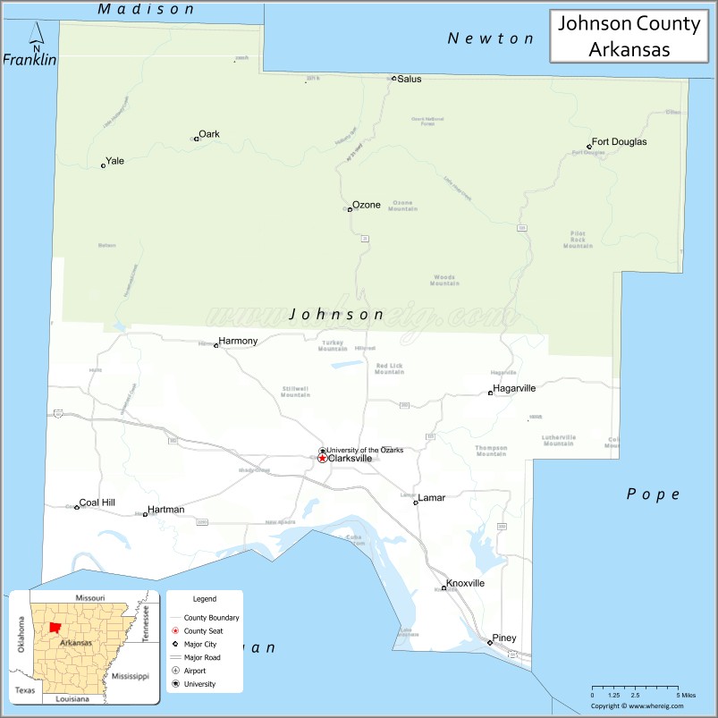
About Johnson County Map, Arkansas: The map showing the county boundary, county seat, major cities, highways, water bodies and neighbouring counties.
Related Arkansas & US Links
Map of Johnson County, Arkansas
Johnson County is a county located in the U.S. state of Arkansas. It's county seat is Clarksville. As per 2020 census, the population of Johnson County is 25845 people and population density is square miles. According to the United States Census Bureau, the county has a total area of 682.74 sq mi (1,768 km2). Johnson County was established on -24150.
Johnson County Facts
| Continent | North America |
| Country | United States |
| State | Arkansas |
| County Seat | Clarksville |
| Largest City/Town | Clarksville |
| Established | 1833 |
| Total Area | 683 sq mi (1,769 sq km) |
| Land Area | 660 sq mi (1,709 sq km) |
| Water Area | 23 sq mi (60 sq km) |
| Population | 25,749 (Census 2020) |
| Population Density | 39.0 people per sq mi |
| Time Zone | Central Time Zone (CST/CDT) |
| Major Highways | Interstate 40, US Highway 64, Arkansas Highway 21 |
| Major Rivers | Arkansas River, Mulberry River |
| Neighboring Counties | Franklin County, Logan County, Madison County, Newton County, Pope County |
| Famous For | Clarksville, University of the Ozarks, peach orchards, and Ozark Mountain recreation |
| Top Attractions | University of the Ozarks, Lake Dardanelle, Ozark National Forest nearby, Clarksville Aquatic Center |
| Official Website | Official Website |
About Johnson County, Arkansas
Johnson County is located in western Arkansas in the United States and was established in 1833. The county seat and largest city is Clarksville. Johnson County is known for its peach orchards, mountain scenery, educational institutions, and outdoor recreation opportunities near the Ozark Mountains and Arkansas River Valley.
Cities and Towns in Johnson County, Arkansas
| City/Town | Population (Census 2020) | Latitude & Longitude |
|---|---|---|
| Clarksville (county seat) | 9,418 | 35.4715°N, 93.4666°W |
| Coal Hill | 1,012 | 35.4390°N, 93.6710°W |
| Hartman | 519 | 35.4320°N, 93.6152°W |
| Lamar | 1,528 | 35.4401°N, 93.3876°W |
| Knoxville | 731 | 35.3810°N, 93.3668°W |
| Oark | Historic mountain community | 35.6853°N, 93.6110°W |
| Lake Dardanelle region | Outdoor recreation area | 35.4400°N, 93.3500°W |
| Ozark Mountain region | Mountain landscape area | 35.6000°N, 93.5500°W |
Golf Courses in Johnson County, Arkansas
| Golf Course | Location | Latitude & Longitude |
|---|---|---|
| Clarksville Country Club | Clarksville | 35.4685°N, 93.4702°W |
| Russellville Country Club | Russellville nearby | 35.2797°N, 93.1528°W |
| Chamberlyne Country Club | Danville nearby | 35.0538°N, 93.3934°W |
Roads and Highways in Johnson County, Arkansas
Major highways connect the county to Little Rock, Fort Smith, and the Ozark Mountains region.
- Interstate 40 - major interstate linking Clarksville with Little Rock and Oklahoma
- US Highway 64 - historic route through the Arkansas River Valley
- Arkansas Highway 21 - scenic mountain highway through the Ozark National Forest region
What Are the Neighboring Counties of Johnson County
- Franklin County (west)
- Logan County (southwest)
- Madison County (northwest)
- Newton County (north)
- Pope County (east)
Whar Are the Top Attractions in Johnson County, Arkansas
The county offers a mix of outdoor recreation, mountain scenery, and cultural attractions.
- University of the Ozarks - historic campus with cultural and athletic events
- Lake Dardanelle recreation areas - boating, fishing, camping, and hiking
- Ozark National Forest nearby - waterfalls, trails, and scenic mountain drives
- Clarksville Aquatic Center - family recreation and water activities
- Historic downtown Clarksville - restaurants, local shops, and community events
- Arkansas River Valley scenic drives - countryside and mountain views
- Oark historic district - famous Ozark mountain community and general store
- Peach orchards and seasonal festivals - celebrations of local agriculture
- Mulberry River recreation nearby - kayaking, canoeing, and fishing adventures
- Nature trails and wildlife observation areas - forests and mountain habitats
- Historic churches and courthouse district - architecture and regional heritage
- Camping and picnic areas throughout the county - family outdoor recreation destinations
What is the Distance from Johnson County to Nearby Cities
The following distances are measured by road (driving).
- Clarksville to Russellville (Pope County), Arkansas - 24 mi (39 km)
- Clarksville to Fort Smith (Sebastian County), Arkansas - 62 mi (100 km)
- Clarksville to Fayetteville (Washington County), Arkansas - 86 mi (138 km)
- Clarksville to Little Rock (Pulaski County), Arkansas - 108 mi (174 km)
- Clarksville to Tulsa (Tulsa County), Oklahoma - 147 mi (237 km)
- Clarksville to Springfield (Greene County), Missouri - 173 mi (278 km)
- Clarksville to Oklahoma City (Oklahoma County), Oklahoma - 243 mi (391 km)
- Clarksville to Kansas City (Jackson County), Missouri - 289 mi (465 km)
- Clarksville to Memphis (Shelby County), Tennessee - 245 mi (394 km)
- Clarksville to Dallas (Dallas County), Texas - 322 mi (518 km)
- Clarksville to St. Louis (St. Louis City), Missouri - 358 mi (576 km)
- Clarksville to Nashville (Davidson County), Tennessee - 442 mi (711 km)
FAQs about Johnson County
Johnson County is located in western Arkansas in the United States.
The population of Johnson County was 25,749 according to the Census 2020.
Johnson County is known for Clarksville, peach orchards, University of the Ozarks, and mountain recreation.
The county is served by Interstate 40, US Highway 64, and Arkansas Highway 21.
Popular attractions include University of the Ozarks, Lake Dardanelle, nearby Ozark National Forest, and the Clarksville Aquatic Center.
References
- QuickFacts - U.S. Census Bureau
- United States Census Bureau
- United States Geological Survey (USGS)
- National Geodetic Survey
- Official Website
- Arkansas County Map
- Ashley County Map
- Baxter County Map
- Benton County Map
- Boone County Map
- Bradley County Map
- Calhoun County Map
- Carroll County Map
- Chicot County Map
- Clark County Map
- Clay County Map
- Cleburne County Map
- Cleveland County Map
- Columbia County Map
- Conway County Map
- Craighead County Map
- Crawford County Map
- Crittenden County Map
- Cross County Map
- Dallas County Map
- Desha County Map
- Drew County Map
- Faulkner County Map
- Franklin County Map
- Fulton County Map
- Garland County Map
- Grant County Map
- Greene County Map
- Hempstead County Map
- Hot Spring County Map
- Howard County Map
- Independence County Map
- Izard County Map
- Jackson County Map
- Jefferson County Map
- Johnson County Map
- Lafayette County Map
- Lawrence County Map
- Lee County Map
- Lincoln County Map
- Little River County Map
- Logan County Map
- Lonoke County Map
- Madison County Map
- Marion County Map
- Miller County Map
- Mississippi County Map
- Monroe County Map
- Montgomery County Map
- Nevada County Map
- Newton County Map
- Ouachita County Map
- Perry County Map
- Phillips County Map
- Pike County Map
- Poinsett County Map
- Polk County Map
- Pope County Map
- Prairie County Map
- Pulaski County Map
- Randolph County Map
- St Francis County Map
- Saline County Map
- Scott County Map
- Searcy County Map
- Sebastian County Map
- Sevier County Map
- Sharp County Map
- Stone County Map
- Union County Map
- Van Buren County Map
- Washington County Map
- White County Map
- Woodruff County Map
- Yell County Map
- Alabama Counties
- Alaska boroughs
- Arizona Counties
- Arkansas Counties
- California County Map
- Colorado Counties
- Connecticut Counties
- Delaware Counties
- Florida County Map
- Georgia County Map
- Hawaii Counties
- Idaho Counties
- Illinois Counties
- Indiana Counties
- Iowa Counties
- Kansas Counties
- Kentucky Counties
- Louisiana Counties
- Maine Counties
- Maryland Counties
- Massachusetts Counties
- Michigan County Map
- Minnesota Counties
- Mississippi Counties
- Missouri Counties
- Montana Counties
- Nebraska Counties
- Nevada Counties
- New York Counties
- New Hampshire Counties
- New Jersey Counties
- New Mexico Counties
- North Carolina Counties
- North Dakota Counties
- Ohio County Map
- Oklahoma Counties
- Oregon Counties
- Pennsylvania Counties
- Rhode Island Counties
- South Carolina Counties
- South Dakota Counties
- Map of Tennessee
- Texas County Map
- Utah Counties
- Vermont Counties
- Virginia Counties
- Washington Counties
- West Virginia Counties
- Wisconsin Counties
- Wyoming Counties