Written and Fact-checked by Whereig Editors, Reviewed by Mukesh Kumar| Last Updated On: May 10, 2026
Map of Nevada County - Nevada County is a county located in the U.S. state of Arkansas. Nevada County Map showing cities, highways, important places and water bodies. Get Where is Nevada County located in the map, major cities in Nevada county, population, areas, and places of interest.
Nevada County Map, Arkansas
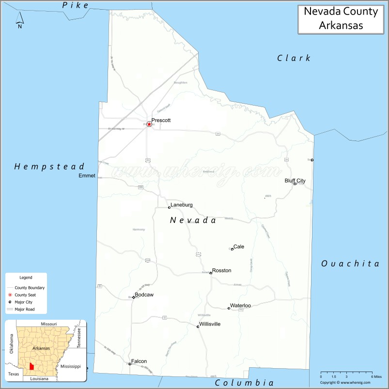
About Nevada County Map, Arkansas: The map showing the county boundary, county seat, major cities, highways, water bodies and neighbouring counties.
Related Arkansas & US Links
Map of Nevada County, Arkansas
Nevada County is a county located in the U.S. state of Arkansas. It's county seat is Prescott. As per 2020 census, the population of Nevada County is 8187 people and population density is square miles. According to the United States Census Bureau, the county has a total area of 620.78 sq mi (1,608 km2). Nevada County was established on -10512.
Nevada County Facts
| Continent | North America |
| Country | United States |
| State | Arkansas |
| County Seat | Prescott |
| Largest City/Town | Prescott |
| Established | March 20, 1871 |
| Total Area | 621 sq mi (1,608 sq km) |
| Land Area | 618 sq mi (1,600 sq km) |
| Water Area | 3 sq mi (8 sq km) |
| Population | 8,297 (Census 2020) |
| Population Density | 13.4 people per sq mi |
| Time Zone | Central Time Zone (CT) |
| Major Highways | Interstate 30, US 67, US 371, AR 24, AR 19 |
| Major Rivers | Little Missouri River |
| Neighboring Counties | Hempstead County, Clark County, Ouachita County, Columbia County, Lafayette County |
| Famous For | Agriculture, timber industry, Prescott, and Civil War history |
| Top Attractions | Prescott Downtown Historic District, Fair Park, White Oak Lake State Park nearby, Nevada County Depot Museum |
| Official Website | Official Website |
About Nevada County, Arkansas
Nevada County is located in the southwestern part of Arkansas in the United States and was established in 1871. The county seat is Prescott, which is also the largest city in the county. The county features rolling timberlands, farmland, and transportation routes that connect southern Arkansas with larger regional cities.
Cities and Towns in Nevada County, Arkansas
| City/Town | Population (Census 2020) | Latitude & Longitude |
|---|---|---|
| Prescott (county seat) | 3,101 | 33.8026°N, 93.3810°W |
| Emmet | 415 | 33.7254°N, 93.4668°W |
| Bluff City | 124 | 33.7118°N, 93.1682°W |
| Rosston | 261 | 33.5837°N, 93.2840°W |
| Willisville | 148 | 33.4979°N, 93.2904°W |
| Bodcaw | 138 | 33.5904°N, 93.3980°W |
Golf Courses in Nevada County, Arkansas
| Golf Course | Location | Latitude & Longitude |
|---|---|---|
| Prescott Country Club | Prescott | 33.7989°N, 93.3918°W |
Roads and Highways in Nevada County, Arkansas
Major highways connect the county to nearby regions and cities.
- Interstate 30 - runs northeast-southwest through the county and connects Prescott with Texarkana and Little Rock
- US Highway 67 - parallel route to Interstate 30 connecting local communities
- US Highway 371 - connects Prescott with southern Arkansas towns and Louisiana routes
- Arkansas Highway 24 - east-west route serving rural parts of the county
- Arkansas Highway 19 - links local communities with nearby counties
What Are the Neighboring Counties of Nevada County
- Clark County (north)
- Ouachita County (east)
- Columbia County (south)
- Lafayette County (southwest)
- Hempstead County (west)
Whar Are the Top Attractions in Nevada County, Arkansas
The county offers a mix of natural and cultural attractions.
- Prescott Downtown Historic District - historic area featuring older commercial buildings and local history
- Nevada County Depot and Museum - local museum focused on railroad and county heritage
- Fair Park - community park in Prescott with sports and picnic facilities
- White Oak Lake State Park - nearby state park known for fishing, camping, and boating
- Little Missouri River - scenic river popular for fishing and outdoor recreation
- Emmet City Park - small-town recreational park with community events
- Prescott City Hall Historic Area - notable historic buildings in the county seat
- Caney Creek Area - rural natural area with wildlife and forest scenery
- Bodcaw Community Area - historic rural community connected to regional farming history
- Nevada County Veterans Memorial - local memorial honoring military veterans
What is the Distance from Nevada County to Nearby Cities
The following distances are measured by road (driving).
- Prescott to Hope (Hempstead County), Arkansas - 34 mi (55 km)
- Prescott to Arkadelphia (Clark County), Arkansas - 52 mi (84 km)
- Prescott to Camden (Ouachita County), Arkansas - 49 mi (79 km)
- Prescott to Magnolia (Columbia County), Arkansas - 44 mi (71 km)
- Prescott to Texarkana (Miller County), Arkansas - 74 mi (119 km)
- Prescott to Little Rock (Pulaski County), Arkansas - 111 mi (179 km)
- Prescott to Nashville (Howard County), Arkansas - 40 mi (64 km)
- Prescott to El Dorado (Union County), Arkansas - 73 mi (117 km)
- Prescott to Malvern (Hot Spring County), Arkansas - 75 mi (121 km)
- Prescott to Shreveport (Caddo Parish), Louisiana - 104 mi (167 km)
- Prescott to Murfreesboro (Pike County), Arkansas - 46 mi (74 km)
- Prescott to Ruston (Lincoln Parish), Louisiana - 118 mi (190 km)
FAQs about Nevada County
Nevada County is located in southwestern Arkansas in the United States.
Nevada County had a population of 8,297 according to the 2020 United States Census.
Nevada County is known for timber production, agriculture, historic Prescott, and transportation routes through southern Arkansas.
The major highways include Interstate 30, US Highway 67, US Highway 371, Arkansas Highway 24, and Arkansas Highway 19.
Yes, Nevada County has local golf facilities including Prescott Country Club in Prescott.
References
- QuickFacts - U.S. Census Bureau
- United States Census Bureau
- United States Geological Survey (USGS)
- National Geodetic Survey
- Official County Website
- Arkansas County Map
- Ashley County Map
- Baxter County Map
- Benton County Map
- Boone County Map
- Bradley County Map
- Calhoun County Map
- Carroll County Map
- Chicot County Map
- Clark County Map
- Clay County Map
- Cleburne County Map
- Cleveland County Map
- Columbia County Map
- Conway County Map
- Craighead County Map
- Crawford County Map
- Crittenden County Map
- Cross County Map
- Dallas County Map
- Desha County Map
- Drew County Map
- Faulkner County Map
- Franklin County Map
- Fulton County Map
- Garland County Map
- Grant County Map
- Greene County Map
- Hempstead County Map
- Hot Spring County Map
- Howard County Map
- Independence County Map
- Izard County Map
- Jackson County Map
- Jefferson County Map
- Johnson County Map
- Lafayette County Map
- Lawrence County Map
- Lee County Map
- Lincoln County Map
- Little River County Map
- Logan County Map
- Lonoke County Map
- Madison County Map
- Marion County Map
- Miller County Map
- Mississippi County Map
- Monroe County Map
- Montgomery County Map
- Nevada County Map
- Newton County Map
- Ouachita County Map
- Perry County Map
- Phillips County Map
- Pike County Map
- Poinsett County Map
- Polk County Map
- Pope County Map
- Prairie County Map
- Pulaski County Map
- Randolph County Map
- St Francis County Map
- Saline County Map
- Scott County Map
- Searcy County Map
- Sebastian County Map
- Sevier County Map
- Sharp County Map
- Stone County Map
- Union County Map
- Van Buren County Map
- Washington County Map
- White County Map
- Woodruff County Map
- Yell County Map
- Alabama Counties
- Alaska boroughs
- Arizona Counties
- Arkansas Counties
- California County Map
- Colorado Counties
- Connecticut Counties
- Delaware Counties
- Florida County Map
- Georgia County Map
- Hawaii Counties
- Idaho Counties
- Illinois Counties
- Indiana Counties
- Iowa Counties
- Kansas Counties
- Kentucky Counties
- Louisiana Counties
- Maine Counties
- Maryland Counties
- Massachusetts Counties
- Michigan County Map
- Minnesota Counties
- Mississippi Counties
- Missouri Counties
- Montana Counties
- Nebraska Counties
- Nevada Counties
- New York Counties
- New Hampshire Counties
- New Jersey Counties
- New Mexico Counties
- North Carolina Counties
- North Dakota Counties
- Ohio County Map
- Oklahoma Counties
- Oregon Counties
- Pennsylvania Counties
- Rhode Island Counties
- South Carolina Counties
- South Dakota Counties
- Map of Tennessee
- Texas County Map
- Utah Counties
- Vermont Counties
- Virginia Counties
- Washington Counties
- West Virginia Counties
- Wisconsin Counties
- Wyoming Counties