Map of Prairie County - Prairie County is a county located in the U.S. state of Arkansas. Prairie County Map showing cities, highways, important places and water bodies. Get Where is Prairie County located in the map, major cities in Prairie county, population, areas, and places of interest.
Prairie County Map, Arkansas
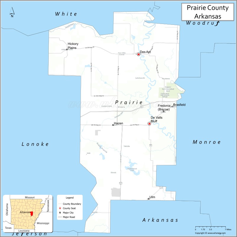
About Prairie County Map, Arkansas: The map showing the county boundary, county seat, major cities, highways, water bodies and neighbouring counties.
Most Viewed Links
Map of Prairie County, Arkansas
"Prairie County is a county located in the U.S. state of Arkansas. It's county seat is Des Arc, DeValls Bluff. As per 2020 census, the population of Prairie County is 8135 people and population density is square miles. According to the United States Census Bureau, the county has a total area of 675.76 sq mi (1,750 km2). Prairie County was established on -19424."
Prairie County Facts
Ctities in Prairie county
| City Name | Type | Population (2020) | Pop. Density | Area | Incorporated |
|---|---|---|---|---|---|
| De Valls Bluff | First class city | 520 | 476.2/sq mi (183.9/km2) | 1.092 sq mi (2.83 km2) | April 4, 1866 |
| Des Arc | Second class city | 1,905 | 906.3/sq mi (349.9/km2) | 2.102 sq mi (5.44 km2) | December 28, 1854 |
| Fredonia (Biscoe) | Town | 305 | 319.4/sq mi (123.3/km2) | 0.955 sq mi (2.47 km2) | July 27, 1909 |
| Hazen | Second class city | 1,481 | 421.0/sq mi (162.5/km2) | 3.518 sq mi (9.11 km2) | July 8, 1884 |
| Ulm | Town | 175 | 670.5/sq mi (258.9/km2) | 0.261 sq mi (0.68 km2) | February 12, 1909 |
- Arkansas County Map
- Ashley County Map
- Baxter County Map
- Benton County Map
- Boone County Map
- Bradley County Map
- Calhoun County Map
- Carroll County Map
- Chicot County Map
- Clark County Map
- Clay County Map
- Cleburne County Map
- Cleveland County Map
- Columbia County Map
- Conway County Map
- Craighead County Map
- Crawford County Map
- Crittenden County Map
- Cross County Map
- Dallas County Map
- Desha County Map
- Drew County Map
- Faulkner County Map
- Franklin County Map
- Fulton County Map
- Garland County Map
- Grant County Map
- Greene County Map
- Hempstead County Map
- Hot Spring County Map
- Howard County Map
- Independence County Map
- Izard County Map
- Jackson County Map
- Jefferson County Map
- Johnson County Map
- Lafayette County Map
- Lawrence County Map
- Lee County Map
- Lincoln County Map
- Little River County Map
- Logan County Map
- Lonoke County Map
- Madison County Map
- Marion County Map
- Miller County Map
- Mississippi County Map
- Monroe County Map
- Montgomery County Map
- Nevada County Map
- Newton County Map
- Ouachita County Map
- Perry County Map
- Phillips County Map
- Pike County Map
- Poinsett County Map
- Polk County Map
- Pope County Map
- Prairie County Map
- Pulaski County Map
- Randolph County Map
- St Francis County Map
- Saline County Map
- Scott County Map
- Searcy County Map
- Sebastian County Map
- Sevier County Map
- Sharp County Map
- Stone County Map
- Union County Map
- Van Buren County Map
- Washington County Map
- White County Map
- Woodruff County Map
- Yell County Map
- Alabama Counties
- Alaska boroughs
- Arizona Counties
- Arkansas Counties
- California County Map
- Colorado Counties
- Connecticut Counties
- Delaware Counties
- Florida County Map
- Georgia County Map
- Hawaii Counties
- Idaho Counties
- Illinois Counties
- Indiana Counties
- Iowa Counties
- Kansas Counties
- Kentucky Counties
- Louisiana Counties
- Maine Counties
- Maryland Counties
- Massachusetts Counties
- Michigan County Map
- Minnesota Counties
- Mississippi Counties
- Missouri Counties
- Montana Counties
- Nebraska Counties
- New Hampshire Counties
- New Jersey Counties
- New Mexico Counties
- North Carolina Counties
- North Dakota Counties
- Oklahoma Counties
- Oregon Counties
- Pennsylvania Counties
- Rhode Island Counties
- South Carolina Counties
- South Dakota Counties
- Map of Tennessee
- Texas County Map
- Utah Counties
- Vermont Counties
- Virginia Counties
- Washington Counties
- West Virginia Counties
- Wisconsin Counties
- Wyoming Counties
- Nevada Counties
- New York Counties
- Ohio County Map