Written and Fact-checked by Whereig Editors, Reviewed by Mukesh Kumar| Last Updated On: May 10, 2026
Map of Clay County - Clay County is a county located in the U.S. state of Arkansas. Clay County Map showing cities, highways, important places and water bodies. Get Where is Clay County located in the map, major cities in Clay county, population, areas, and places of interest.
Clay County Map, Arkansas
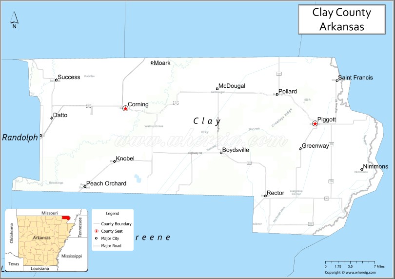
About Clay County Map, Arkansas: The map showing the county boundary, county seat, major cities, highways, water bodies and neighbouring counties.
Related Arkansas & US Links
Map of Clay County, Arkansas
"Clay County is a county located in the U.S. state of Arkansas. It's county seat is Piggott, Corning. As per 2020 census, the population of Clay County is 14350 people and population density is square miles. According to the United States Census Bureau, the county has a total area of 641.42 sq mi (1,661 km2). Clay County was established on -9777."
Clay County Facts
| Continent | North America |
| Country | United States |
| State | Arkansas |
| County Seats | Corning and Piggott |
| Largest City/Town | Piggott |
| Established | 1873 |
| Total Area | 641 sq mi (1,660 sq km) |
| Land Area | 639 sq mi (1,655 sq km) |
| Water Area | 2 sq mi (5 sq km) |
| Population | 14,552 (Census 2020) |
| Population Density | 22.8 people per sq mi |
| Time Zone | Central Time Zone (CST/CDT) |
| Major Highways | US Highway 62, US Highway 67, Arkansas Highway 139 |
| Major Rivers | Black River, St. Francis River |
| Neighboring Counties | Randolph County, Greene County, Dunklin County (MO), Butler County (MO), Ripley County (MO) |
| Famous For | Arkansas Delta agriculture, Hemingway-Pfeiffer Museum, Black River, and northeastern Arkansas history |
| Top Attractions | Hemingway-Pfeiffer Museum, Black River recreation, Crowley’s Ridge scenery, Piggott heritage sites |
| Official Website | Official Website |
About Clay County, Arkansas
Clay County is located in northeastern Arkansas in the United States and was established in 1873. The county has two county seats, Corning and Piggott. Clay County is known for farming, river recreation, literary history connected to Ernest Hemingway, and scenic landscapes along Crowley’s Ridge and the Black River.
Cities and Towns in Clay County, Arkansas
| City/Town | Population (Census 2020) | Latitude & Longitude |
|---|---|---|
| Piggott (county seat) | 3,603 | 36.3837°N, 90.1901°W |
| Corning (county seat) | 3,227 | 36.4070°N, 90.5790°W |
| Rector | 1,862 | 36.2648°N, 90.2934°W |
| Knobel | 709 | 36.3198°N, 90.6082°W |
| Greenway | 248 | 36.3365°N, 90.2162°W |
| McDougal | 186 | 36.4381°N, 90.3890°W |
| Datto | Historic community | 36.3887°N, 90.7265°W |
| Crowley’s Ridge region | Scenic upland area | 36.3500°N, 90.3000°W |
Golf Courses in Clay County, Arkansas
| Golf Course | Location | Latitude & Longitude |
|---|---|---|
| Piggott Country Club | Piggott | 36.3860°N, 90.1942°W |
| Corning Country Club | Corning | 36.4094°N, 90.5753°W |
| Paragould Country Club | Paragould nearby | 36.0557°N, 90.4901°W |
Roads and Highways in Clay County, Arkansas
Major highways connect the county to northeastern Arkansas, Missouri, and Delta agricultural communities.
- US Highway 62 - east-west route linking Clay County with Missouri and northern Arkansas towns
- US Highway 67 - regional highway connecting Corning with Jonesboro and Missouri routes
- Arkansas Highway 139 - scenic highway serving rural farming and river communities
What Are the Neighboring Counties of Clay County
- Randolph County (west)
- Greene County (south)
- Dunklin County, Missouri (east)
- Butler County, Missouri (northwest)
- Ripley County, Missouri (north)
Whar Are the Top Attractions in Clay County, Arkansas
The county offers a mix of literary history, river recreation, and Delta cultural attractions.
- Hemingway-Pfeiffer Museum and Educational Center - Ernest Hemingway writing site and literary museum
- Black River recreation areas - fishing, boating, and outdoor activities
- Crowley’s Ridge scenic landscapes - rolling hills and forested scenery in northeastern Arkansas
- Historic downtown Piggott - local shops, restaurants, and heritage buildings
- Corning courthouse square - historic architecture and community events
- St. Francis River wildlife areas nearby - birdwatching and wetlands recreation
- Clay County Heritage Center - exhibits on local history and pioneer settlement
- Fishing lakes and rural parks - camping and family recreation opportunities
- Historic rail and agricultural heritage sites - reminders of Delta farming history
- Annual community fairs and festivals - celebrations of local culture and traditions
- Delta scenic drives - farmland, forests, and river valley landscapes
- Nearby Dave Donaldson Black River Wildlife Management Area - hunting and nature activities
What is the Distance from Clay County to Nearby Cities
The following distances are measured by road (driving).
- Piggott to Paragould (Greene County), Arkansas - 28 mi (45 km)
- Piggott to Jonesboro (Craighead County), Arkansas - 54 mi (87 km)
- Piggott to Poplar Bluff (Butler County), Missouri - 48 mi (77 km)
- Piggott to Cape Girardeau (Cape Girardeau County), Missouri - 118 mi (190 km)
- Piggott to Memphis (Shelby County), Tennessee - 122 mi (196 km)
- Piggott to Springfield (Greene County), Missouri - 189 mi (304 km)
- Piggott to Little Rock (Pulaski County), Arkansas - 167 mi (269 km)
- Piggott to St. Louis (St. Louis City), Missouri - 252 mi (406 km)
- Piggott to Nashville (Davidson County), Tennessee - 286 mi (460 km)
- Piggott to Tulsa (Tulsa County), Oklahoma - 297 mi (478 km)
- Piggott to Kansas City (Jackson County), Missouri - 364 mi (586 km)
- Piggott to Dallas (Dallas County), Texas - 494 mi (795 km)
FAQs about Clay County
Clay County is located in northeastern Arkansas near the Missouri border in the United States.
The population of Clay County was 14,552 according to the Census 2020.
Clay County is known for Delta agriculture, the Hemingway-Pfeiffer Museum, Black River recreation, and Crowley’s Ridge scenery.
The county is served by US Highway 62, US Highway 67, and Arkansas Highway 139.
Popular attractions include the Hemingway-Pfeiffer Museum, Black River recreation areas, Crowley’s Ridge landscapes, and historic downtown Piggott.
References
- QuickFacts - U.S. Census Bureau
- United States Census Bureau
- United States Geological Survey (USGS)
- National Geodetic Survey
- Official Website
- Arkansas County Map
- Ashley County Map
- Baxter County Map
- Benton County Map
- Boone County Map
- Bradley County Map
- Calhoun County Map
- Carroll County Map
- Chicot County Map
- Clark County Map
- Clay County Map
- Cleburne County Map
- Cleveland County Map
- Columbia County Map
- Conway County Map
- Craighead County Map
- Crawford County Map
- Crittenden County Map
- Cross County Map
- Dallas County Map
- Desha County Map
- Drew County Map
- Faulkner County Map
- Franklin County Map
- Fulton County Map
- Garland County Map
- Grant County Map
- Greene County Map
- Hempstead County Map
- Hot Spring County Map
- Howard County Map
- Independence County Map
- Izard County Map
- Jackson County Map
- Jefferson County Map
- Johnson County Map
- Lafayette County Map
- Lawrence County Map
- Lee County Map
- Lincoln County Map
- Little River County Map
- Logan County Map
- Lonoke County Map
- Madison County Map
- Marion County Map
- Miller County Map
- Mississippi County Map
- Monroe County Map
- Montgomery County Map
- Nevada County Map
- Newton County Map
- Ouachita County Map
- Perry County Map
- Phillips County Map
- Pike County Map
- Poinsett County Map
- Polk County Map
- Pope County Map
- Prairie County Map
- Pulaski County Map
- Randolph County Map
- St Francis County Map
- Saline County Map
- Scott County Map
- Searcy County Map
- Sebastian County Map
- Sevier County Map
- Sharp County Map
- Stone County Map
- Union County Map
- Van Buren County Map
- Washington County Map
- White County Map
- Woodruff County Map
- Yell County Map
- Alabama Counties
- Alaska boroughs
- Arizona Counties
- Arkansas Counties
- California County Map
- Colorado Counties
- Connecticut Counties
- Delaware Counties
- Florida County Map
- Georgia County Map
- Hawaii Counties
- Idaho Counties
- Illinois Counties
- Indiana Counties
- Iowa Counties
- Kansas Counties
- Kentucky Counties
- Louisiana Counties
- Maine Counties
- Maryland Counties
- Massachusetts Counties
- Michigan County Map
- Minnesota Counties
- Mississippi Counties
- Missouri Counties
- Montana Counties
- Nebraska Counties
- Nevada Counties
- New York Counties
- New Hampshire Counties
- New Jersey Counties
- New Mexico Counties
- North Carolina Counties
- North Dakota Counties
- Ohio County Map
- Oklahoma Counties
- Oregon Counties
- Pennsylvania Counties
- Rhode Island Counties
- South Carolina Counties
- South Dakota Counties
- Map of Tennessee
- Texas County Map
- Utah Counties
- Vermont Counties
- Virginia Counties
- Washington Counties
- West Virginia Counties
- Wisconsin Counties
- Wyoming Counties