Map of Independence County - Independence County is a county located in the U.S. state of Arkansas. Independence County Map showing cities, highways, important places and water bodies. Get Where is Independence County located in the map, major cities in Independence county, population, areas, and places of interest.
Independence County Map, Arkansas
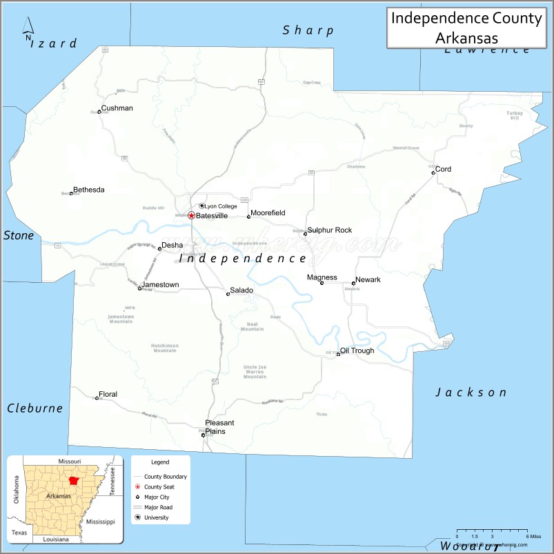
About Independence County Map, Arkansas: The map showing the county boundary, county seat, major cities, highways, water bodies and neighbouring counties.
Most Viewed Links
Map of Independence County, Arkansas
Independence County is a county located in the U.S. state of Arkansas. It's county seat is Batesville. As per 2020 census, the population of Independence County is 37723 people and population density is square miles. According to the United States Census Bureau, the county has a total area of 771.57 sq mi (1,998 km2). Independence County was established on -28925.
Independence County Facts
| County Info | Facts |
|---|---|
| County | Independence County |
| County Seat | Batesville |
| State | Arkansas |
| Country | United States |
| FIPS code | 63 |
| Established | -28925 |
| Area | 771.57 sq mi (1,998 km2) |
| Population | 37723 |
| Density | |
| Formed / Origin | Lawrence County (1820) |
Ctities in Independence county
| City Name | Type | Population (2020) | Pop. Density | Area | Incorporated |
|---|---|---|---|---|---|
| Batesville | First class city | 11,191 | 965.2/sq mi (372.6/km2) | 11.595 sq mi (30.03 km2) | December 20, 1848 |
| Cushman | Second class city | 433 | 106.2/sq mi (41.0/km2) | 4.076 sq mi (10.56 km2) | March 12, 1906 |
| Magness | Town | 220 | 358.3/sq mi (138.3/km2) | 0.614 sq mi (1.59 km2) | October 26, 1906 |
| Moorefield | Town | 126 | 111.4/sq mi (43.0/km2) | 1.131 sq mi (2.93 km2) | January 29, 1969 |
| Newark | Second class city | 1,180 | 717.3/sq mi (277.0/km2) | 1.645 sq mi (4.26 km2) | April 12, 1889 |
| Oil Trough | Town | 226 | 986.9/sq mi (381.0/km2) | 0.229 sq mi (0.59 km2) | July 22, 1959 |
| Pleasant Plains | Town | 352 | 344.1/sq mi (132.9/km2) | 1.023 sq mi (2.65 km2) | May 25, 1907 |
| Southside | Second class city | 4,279 | 434.2/sq mi (167.6/km2) | 9.855 sq mi (25.52 km2) | October 24, 2014 |
| Sulphur Rock | Town | 609 | 487.2/sq mi (188.1/km2) | 1.25 sq mi (3.24 km2) | August 20, 1887 |
| Cave City | Second class city | 1,922 | 751.7/sq mi (290.2/km2) | 2.557 sq mi (6.62 km2) | April 29, 1907 |
Places to Visit in Independence
Top places to visit in Independence includes Batesville Community, Batesville Parks & Recreation, Maxfield Park, Riverside Park, Jamestown Crag, Old Independence.
Highways in Independence
U.S. Highway 167, Highway 14, Highway 25, Highway 37, Highway 69, Highway 69 , Highway 87, Highway 106, Highway 122, Highway 157, Highway 230, Highway 233, Highway 333, Highway 367, Highway 394.
Nearest Airports
Nearest airport of Independence is Batesville Regional Airport-BVX.
- Arkansas County Map
- Ashley County Map
- Baxter County Map
- Benton County Map
- Boone County Map
- Bradley County Map
- Calhoun County Map
- Carroll County Map
- Chicot County Map
- Clark County Map
- Clay County Map
- Cleburne County Map
- Cleveland County Map
- Columbia County Map
- Conway County Map
- Craighead County Map
- Crawford County Map
- Crittenden County Map
- Cross County Map
- Dallas County Map
- Desha County Map
- Drew County Map
- Faulkner County Map
- Franklin County Map
- Fulton County Map
- Garland County Map
- Grant County Map
- Greene County Map
- Hempstead County Map
- Hot Spring County Map
- Howard County Map
- Independence County Map
- Izard County Map
- Jackson County Map
- Jefferson County Map
- Johnson County Map
- Lafayette County Map
- Lawrence County Map
- Lee County Map
- Lincoln County Map
- Little River County Map
- Logan County Map
- Lonoke County Map
- Madison County Map
- Marion County Map
- Miller County Map
- Mississippi County Map
- Monroe County Map
- Montgomery County Map
- Nevada County Map
- Newton County Map
- Ouachita County Map
- Perry County Map
- Phillips County Map
- Pike County Map
- Poinsett County Map
- Polk County Map
- Pope County Map
- Prairie County Map
- Pulaski County Map
- Randolph County Map
- St Francis County Map
- Saline County Map
- Scott County Map
- Searcy County Map
- Sebastian County Map
- Sevier County Map
- Sharp County Map
- Stone County Map
- Union County Map
- Van Buren County Map
- Washington County Map
- White County Map
- Woodruff County Map
- Yell County Map
- Alabama Counties
- Alaska boroughs
- Arizona Counties
- Arkansas Counties
- California County Map
- Colorado Counties
- Connecticut Counties
- Delaware Counties
- Florida County Map
- Georgia County Map
- Hawaii Counties
- Idaho Counties
- Illinois Counties
- Indiana Counties
- Iowa Counties
- Kansas Counties
- Kentucky Counties
- Louisiana Counties
- Maine Counties
- Maryland Counties
- Massachusetts Counties
- Michigan County Map
- Minnesota Counties
- Mississippi Counties
- Missouri Counties
- Montana Counties
- Nebraska Counties
- New Hampshire Counties
- New Jersey Counties
- New Mexico Counties
- North Carolina Counties
- North Dakota Counties
- Oklahoma Counties
- Oregon Counties
- Pennsylvania Counties
- Rhode Island Counties
- South Carolina Counties
- South Dakota Counties
- Map of Tennessee
- Texas County Map
- Utah Counties
- Vermont Counties
- Virginia Counties
- Washington Counties
- West Virginia Counties
- Wisconsin Counties
- Wyoming Counties
- Nevada Counties
- New York Counties
- Ohio County Map