Written and Fact-checked by Whereig Editors, Reviewed by Mukesh Kumar| Last Updated On: May 10, 2026
Map of Montgomery County - Montgomery County is a county located in the U.S. state of Arkansas. Montgomery County Map showing cities, highways, important places and water bodies. Get Where is Montgomery County located in the map, major cities in Montgomery county, population, areas, and places of interest.
Montgomery County Map, Arkansas
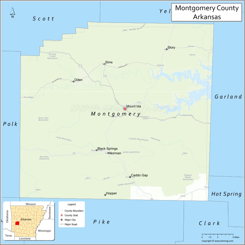
About Montgomery County Map, Arkansas: The map showing the county boundary, county seat, major cities, highways, water bodies and neighbouring counties.
Related Arkansas & US Links
Map of Montgomery County, Arkansas
Montgomery County is a county located in the U.S. state of Arkansas. It's county seat is Mount Ida. As per 2020 census, the population of Montgomery County is 8611 people and population density is square miles. According to the United States Census Bureau, the county has a total area of 800.29 sq mi (2,073 km2). Montgomery County was established on -20840.
Montgomery County Facts
| Continent | North America |
| Country | United States |
| State | Arkansas |
| County Seat | Mount Ida |
| Largest City/Town | Mount Ida |
| Established | December 9, 1842 |
| Total Area | 800 sq mi (2,072 sq km) |
| Land Area | 780 sq mi (2,020 sq km) |
| Water Area | 20 sq mi (52 sq km) |
| Population | 8,484 (Census 2020) |
| Population Density | 10.9 people per sq mi |
| Time Zone | Central Time Zone (CT) |
| Major Highways | US 270, AR 8, AR 27, AR 298 |
| Major Rivers | Ouachita River, Caddo River |
| Neighboring Counties | Yell County, Garland County, Pike County, Polk County, Scott County, Perry County |
| Famous For | Lake Ouachita, crystal mining, Ouachita National Forest |
| Top Attractions | Lake Ouachita, Wegner Crystal Mines, Twin Creek Crystal Mine, Ouachita National Forest |
| Official Website | Official Website |
About Montgomery County, Arkansas
Montgomery County is located in the western part of Arkansas in the United States and was established in 1842. The county seat is Mount Ida, which is also the largest town in the county. The area is known for its forested mountains, crystal deposits, scenic lakes, and outdoor recreation opportunities in the Ouachita Mountains region.
Cities and Towns in Montgomery County, Arkansas
| City/Town | Population (Census 2020) | Latitude & Longitude |
|---|---|---|
| Mount Ida (county seat) | 996 | 34.5565°N, 93.6341°W |
| Norman | 303 | 34.4598°N, 93.6816°W |
| Black Springs | 95 | 34.4595°N, 93.6788°W |
| Caddo Gap | 223 | 34.3987°N, 93.6086°W |
| Oden (CDP) | 180 | 34.6217°N, 93.7715°W |
| Pencil Bluff (CDP) | 72 | 34.6435°N, 93.7096°W |
| Sims (CDP) | 39 | 34.6568°N, 93.7984°W |
Golf Courses in Montgomery County, Arkansas
| Golf Course | Location | Latitude & Longitude |
|---|---|---|
| Glenwood Country Club | Near Mount Ida region | 34.5610°N, 93.6200°W |
| Mountain Harbor Golf Area | Mount Ida | 34.5785°N, 93.5189°W |
Roads and Highways in Montgomery County, Arkansas
Major highways connect the county to nearby regions and cities.
- US Highway 270 - runs east-west through Mount Ida and connects the county with Hot Springs and Mena
- Arkansas Highway 8 - connects Mount Ida with Arkadelphia and Mena
- Arkansas Highway 27 - connects northern and southern rural communities in the county
- Arkansas Highway 298 - provides access to Lake Ouachita recreation areas
What Are the Neighboring Counties of Montgomery County
- Perry County (northeast)
- Yell County (north)
- Garland County (east)
- Pike County (south)
- Polk County (west)
- Scott County (northwest)
Whar Are the Top Attractions in Montgomery County, Arkansas
The county offers a mix of natural and cultural attractions.
- Lake Ouachita - a large scenic lake popular for boating, fishing, and camping
- Ouachita National Forest - forested mountain area with hiking trails and wildlife viewing
- Wegner Crystal Mines - famous quartz crystal digging destination near Mount Ida
- Twin Creek Crystal Mine - public crystal mine known for family-friendly digging activities
- Mount Ida Crystal District - area known as the Quartz Crystal Capital of the World
- Caddo River - popular river for kayaking, canoeing, and fishing
- Joplin Recreation Area - lakeside camping and picnic area on Lake Ouachita
- Charlton Recreation Area - Ouachita National Forest recreation spot with trails and camping
- Shady Lake Recreation Area - peaceful mountain lake with hiking and fishing opportunities
- Womble Trail - scenic mountain biking and hiking trail through the Ouachita Mountains
What is the Distance from Montgomery County to Nearby Cities
The following distances are measured by road (driving).
- Mount Ida to Hot Springs (Garland County), Arkansas - 47 mi (76 km)
- Mount Ida to Mena (Polk County), Arkansas - 56 mi (90 km)
- Mount Ida to Arkadelphia (Clark County), Arkansas - 73 mi (117 km)
- Mount Ida to Little Rock (Pulaski County), Arkansas - 98 mi (158 km)
- Mount Ida to Russellville (Pope County), Arkansas - 88 mi (142 km)
- Mount Ida to Glenwood (Pike County), Arkansas - 35 mi (56 km)
- Mount Ida to Waldron (Scott County), Arkansas - 72 mi (116 km)
- Mount Ida to Malvern (Hot Spring County), Arkansas - 66 mi (106 km)
- Mount Ida to Murfreesboro (Pike County), Arkansas - 54 mi (87 km)
- Mount Ida to Booneville (Logan County), Arkansas - 90 mi (145 km)
- Mount Ida to Fort Smith (Sebastian County), Arkansas - 120 mi (193 km)
- Mount Ida to Texarkana (Miller County), Arkansas - 132 mi (212 km)
FAQs about Montgomery County
Montgomery County is located in western Arkansas within the Ouachita Mountains region of the United States.
The population of Montgomery County was 8,484 according to the 2020 United States Census.
Montgomery County is known for Lake Ouachita, quartz crystal mining, mountain scenery, and outdoor recreation.
The main highways include US Highway 270, Arkansas Highway 8, Arkansas Highway 27, and Arkansas Highway 298.
Yes, Montgomery County has golf facilities and nearby recreational golf areas serving residents and visitors.
References
- QuickFacts - U.S. Census Bureau
- United States Census Bureau
- United States Geological Survey (USGS)
- National Geodetic Survey
- Official County Website
- Arkansas County Map
- Ashley County Map
- Baxter County Map
- Benton County Map
- Boone County Map
- Bradley County Map
- Calhoun County Map
- Carroll County Map
- Chicot County Map
- Clark County Map
- Clay County Map
- Cleburne County Map
- Cleveland County Map
- Columbia County Map
- Conway County Map
- Craighead County Map
- Crawford County Map
- Crittenden County Map
- Cross County Map
- Dallas County Map
- Desha County Map
- Drew County Map
- Faulkner County Map
- Franklin County Map
- Fulton County Map
- Garland County Map
- Grant County Map
- Greene County Map
- Hempstead County Map
- Hot Spring County Map
- Howard County Map
- Independence County Map
- Izard County Map
- Jackson County Map
- Jefferson County Map
- Johnson County Map
- Lafayette County Map
- Lawrence County Map
- Lee County Map
- Lincoln County Map
- Little River County Map
- Logan County Map
- Lonoke County Map
- Madison County Map
- Marion County Map
- Miller County Map
- Mississippi County Map
- Monroe County Map
- Montgomery County Map
- Nevada County Map
- Newton County Map
- Ouachita County Map
- Perry County Map
- Phillips County Map
- Pike County Map
- Poinsett County Map
- Polk County Map
- Pope County Map
- Prairie County Map
- Pulaski County Map
- Randolph County Map
- St Francis County Map
- Saline County Map
- Scott County Map
- Searcy County Map
- Sebastian County Map
- Sevier County Map
- Sharp County Map
- Stone County Map
- Union County Map
- Van Buren County Map
- Washington County Map
- White County Map
- Woodruff County Map
- Yell County Map
- Alabama Counties
- Alaska boroughs
- Arizona Counties
- Arkansas Counties
- California County Map
- Colorado Counties
- Connecticut Counties
- Delaware Counties
- Florida County Map
- Georgia County Map
- Hawaii Counties
- Idaho Counties
- Illinois Counties
- Indiana Counties
- Iowa Counties
- Kansas Counties
- Kentucky Counties
- Louisiana Counties
- Maine Counties
- Maryland Counties
- Massachusetts Counties
- Michigan County Map
- Minnesota Counties
- Mississippi Counties
- Missouri Counties
- Montana Counties
- Nebraska Counties
- Nevada Counties
- New York Counties
- New Hampshire Counties
- New Jersey Counties
- New Mexico Counties
- North Carolina Counties
- North Dakota Counties
- Ohio County Map
- Oklahoma Counties
- Oregon Counties
- Pennsylvania Counties
- Rhode Island Counties
- South Carolina Counties
- South Dakota Counties
- Map of Tennessee
- Texas County Map
- Utah Counties
- Vermont Counties
- Virginia Counties
- Washington Counties
- West Virginia Counties
- Wisconsin Counties
- Wyoming Counties