Written and Fact-checked by Whereig Editors, Reviewed by Mukesh Kumar| Last Updated On: May 10, 2026
Map of Miller County - Miller County is a county located in the U.S. state of Arkansas. Miller County Map showing cities, highways, important places and water bodies. Get Where is Miller County located in the map, major cities in Miller county, population, areas, and places of interest.
Miller County Map, Arkansas
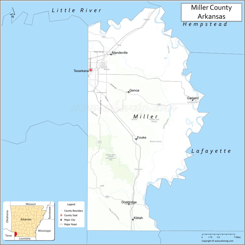
About Miller County Map, Arkansas: The map showing the county boundary, county seat, major cities, highways, water bodies and neighbouring counties.
Related Arkansas & US Links
Map of Miller County, Arkansas
Miller County is a county located in the U.S. state of Arkansas. It's county seat is Texarkana. As per 2020 census, the population of Miller County is 42649 people and population density is square miles. According to the United States Census Bureau, the county has a total area of 637.48 sq mi (1,651 km2). Miller County was established on April 1, 1820[Note 2].
Miller County Facts
| Continent | North America |
| Country | United States |
| State | Arkansas |
| County Seat | Texarkana |
| Largest City/Town | Texarkana |
| Established | 1820 (re-established 1874) |
| Total Area | 637 sq mi (1,650 sq km) |
| Land Area | 624 sq mi (1,616 sq km) |
| Water Area | 13 sq mi (34 sq km) |
| Population | 42,600 (Census 2020) |
| Population Density | 68.3 people per sq mi |
| Time Zone | Central Time Zone (CST/CDT) |
| Major Highways | Interstate 30, US Highway 67, US Highway 71, US Highway 82 |
| Major Rivers | Red River, Sulphur River |
| Neighboring Counties | Hempstead County, Lafayette County, Little River County, Bowie County (TX), Cass County (TX) |
| Famous For | Texarkana, state-line culture, transportation hub, and Red River recreation |
| Top Attractions | State Line Post Office, Spring Lake Park, Perot Theatre nearby, Wright Patman Lake nearby |
| Official Website | Official Website |
About Miller County, Arkansas
Miller County is located in southwestern Arkansas in the United States and was originally established in 1820 before being re-established in 1874. The county seat and largest city is Texarkana. Miller County is known for its unique state-line culture, major transportation routes, regional commerce, and recreational opportunities along the Red River and nearby lakes.
Cities and Towns in Miller County, Arkansas
| City/Town | Population (Census 2020) | Latitude & Longitude |
|---|---|---|
| Texarkana (county seat) | 29,387 | 33.4251°N, 94.0477°W |
| Fouke | 808 | 33.2612°N, 93.8916°W |
| Garland | 242 | 33.3637°N, 93.7085°W |
| Doddridge | 242 | 33.0987°N, 93.9296°W |
| Ogden | 180 | 33.5876°N, 94.0277°W |
| Redwater region | Rural recreation area | 33.3500°N, 94.1000°W |
| Red River region | River landscape area | 33.3000°N, 94.0000°W |
| Southwest Arkansas timber region | Forest landscape area | 33.2500°N, 93.9500°W |
Golf Courses in Miller County, Arkansas
| Golf Course | Location | Latitude & Longitude |
|---|---|---|
| Texarkana Country Club | Texarkana | 33.4760°N, 94.0521°W |
| Northridge Country Club | Texarkana | 33.4665°N, 94.0658°W |
| Oak Grove Golf Club | New Boston nearby | 33.4608°N, 94.3987°W |
Roads and Highways in Miller County, Arkansas
Major highways make the county a key transportation and commerce hub for southwest Arkansas and northeast Texas.
- Interstate 30 - major interstate linking Texarkana with Little Rock and Dallas
- US Highway 67 - important regional transportation route through Texarkana
- US Highway 71 - north-south corridor connecting Arkansas, Texas, and Louisiana
- US Highway 82 - east-west highway serving southern Arkansas communities
What Are the Neighboring Counties of Miller County
- Hempstead County (northeast)
- Lafayette County (east)
- Little River County (north)
- Bowie County, Texas (west)
- Cass County, Texas (southwest)
Whar Are the Top Attractions in Miller County, Arkansas
The county offers a mix of regional attractions, outdoor recreation, and state-line cultural experiences.
- State Line Post Office and Federal Building - famous landmark located on the Arkansas-Texas border
- Spring Lake Park - walking trails, sports facilities, and family recreation
- Perot Theatre nearby - historic performing arts venue in downtown Texarkana
- Wright Patman Lake nearby - boating, fishing, camping, and outdoor recreation
- Historic downtown Texarkana - museums, restaurants, shopping, and entertainment
- Red River recreation areas - fishing, kayaking, and wildlife observation
- Regional festivals and cultural events - celebrations of Arkansas and Texas heritage
- Nature trails and birdwatching sites - wetlands and forest habitats
- Historic railroad and transportation museums - local history and regional commerce heritage
- Nearby Fouke Monster folklore attractions - local legends and tourism interest
- Fishing lodges and campgrounds throughout the county - outdoor recreation destinations
- Community parks and sports complexes - family-friendly activities and events
What is the Distance from Miller County to Nearby Cities
The following distances are measured by road (driving).
- Texarkana to Hope (Hempstead County), Arkansas - 32 mi (51 km)
- Texarkana to Shreveport (Caddo Parish), Louisiana - 72 mi (116 km)
- Texarkana to Little Rock (Pulaski County), Arkansas - 143 mi (230 km)
- Texarkana to Dallas (Dallas County), Texas - 181 mi (291 km)
- Texarkana to Tyler (Smith County), Texas - 106 mi (171 km)
- Texarkana to Monroe (Ouachita Parish), Louisiana - 146 mi (235 km)
- Texarkana to Oklahoma City (Oklahoma County), Oklahoma - 295 mi (475 km)
- Texarkana to Tulsa (Tulsa County), Oklahoma - 263 mi (423 km)
- Texarkana to Jackson (Hinds County), Mississippi - 257 mi (414 km)
- Texarkana to Memphis (Shelby County), Tennessee - 280 mi (451 km)
- Texarkana to New Orleans (Orleans Parish), Louisiana - 389 mi (626 km)
- Texarkana to Kansas City (Jackson County), Missouri - 436 mi (702 km)
FAQs about Miller County
Miller County is located in southwestern Arkansas near the Texas border in the United States.
The population of Miller County was 42,600 according to the Census 2020.
Miller County is known for Texarkana, state-line culture, transportation routes, and Red River recreation.
The county is served by Interstate 30, US Highway 67, US Highway 71, and US Highway 82.
Popular attractions include the State Line Post Office, Spring Lake Park, nearby Wright Patman Lake, and downtown Texarkana.
References
- QuickFacts - U.S. Census Bureau
- United States Census Bureau
- United States Geological Survey (USGS)
- National Geodetic Survey
- Official Website
- Arkansas County Map
- Ashley County Map
- Baxter County Map
- Benton County Map
- Boone County Map
- Bradley County Map
- Calhoun County Map
- Carroll County Map
- Chicot County Map
- Clark County Map
- Clay County Map
- Cleburne County Map
- Cleveland County Map
- Columbia County Map
- Conway County Map
- Craighead County Map
- Crawford County Map
- Crittenden County Map
- Cross County Map
- Dallas County Map
- Desha County Map
- Drew County Map
- Faulkner County Map
- Franklin County Map
- Fulton County Map
- Garland County Map
- Grant County Map
- Greene County Map
- Hempstead County Map
- Hot Spring County Map
- Howard County Map
- Independence County Map
- Izard County Map
- Jackson County Map
- Jefferson County Map
- Johnson County Map
- Lafayette County Map
- Lawrence County Map
- Lee County Map
- Lincoln County Map
- Little River County Map
- Logan County Map
- Lonoke County Map
- Madison County Map
- Marion County Map
- Miller County Map
- Mississippi County Map
- Monroe County Map
- Montgomery County Map
- Nevada County Map
- Newton County Map
- Ouachita County Map
- Perry County Map
- Phillips County Map
- Pike County Map
- Poinsett County Map
- Polk County Map
- Pope County Map
- Prairie County Map
- Pulaski County Map
- Randolph County Map
- St Francis County Map
- Saline County Map
- Scott County Map
- Searcy County Map
- Sebastian County Map
- Sevier County Map
- Sharp County Map
- Stone County Map
- Union County Map
- Van Buren County Map
- Washington County Map
- White County Map
- Woodruff County Map
- Yell County Map
- Alabama Counties
- Alaska boroughs
- Arizona Counties
- Arkansas Counties
- California County Map
- Colorado Counties
- Connecticut Counties
- Delaware Counties
- Florida County Map
- Georgia County Map
- Hawaii Counties
- Idaho Counties
- Illinois Counties
- Indiana Counties
- Iowa Counties
- Kansas Counties
- Kentucky Counties
- Louisiana Counties
- Maine Counties
- Maryland Counties
- Massachusetts Counties
- Michigan County Map
- Minnesota Counties
- Mississippi Counties
- Missouri Counties
- Montana Counties
- Nebraska Counties
- Nevada Counties
- New York Counties
- New Hampshire Counties
- New Jersey Counties
- New Mexico Counties
- North Carolina Counties
- North Dakota Counties
- Ohio County Map
- Oklahoma Counties
- Oregon Counties
- Pennsylvania Counties
- Rhode Island Counties
- South Carolina Counties
- South Dakota Counties
- Map of Tennessee
- Texas County Map
- Utah Counties
- Vermont Counties
- Virginia Counties
- Washington Counties
- West Virginia Counties
- Wisconsin Counties
- Wyoming Counties