Written and Fact-checked by Whereig Editors, Reviewed by Mukesh Kumar| Last Updated On: May 10, 2026
Map of Crawford County - Crawford County is a county located in the U.S. state of Arkansas. Crawford County Map showing cities, highways, important places and water bodies. Get Where is Crawford County located in the map, major cities in Crawford county, population, areas, and places of interest.
Crawford County Map, Arkansas
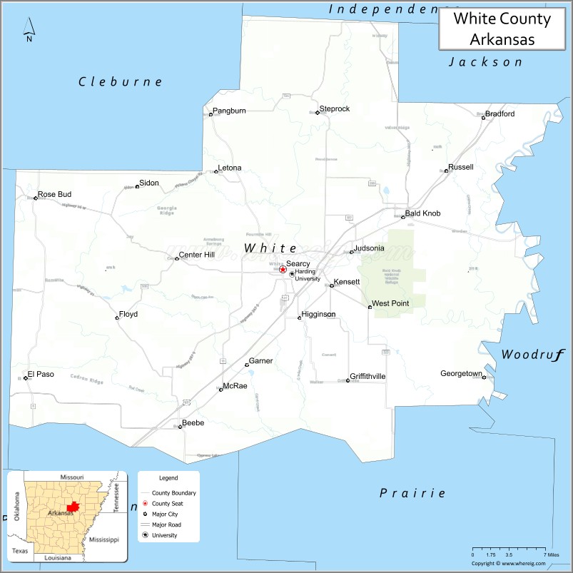
About Crawford County Map, Arkansas: The map showing the county boundary, county seat, major cities, highways, water bodies and neighbouring counties.
Related Arkansas & US Links
Map of Crawford County, Arkansas
Crawford County is a county located in the U.S. state of Arkansas. It's county seat is Van Buren. As per 2020 census, the population of Crawford County is 60378 people and population density is square miles. According to the United States Census Bureau, the county has a total area of 604.20 sq mi (1,565 km2). Crawford County was established on -28927.
Crawford County Facts
| Continent | North America |
| Country | United States |
| State | Arkansas |
| County Seat | Van Buren |
| Largest City/Town | Van Buren |
| Established | 1820 |
| Total Area | 604 sq mi (1,564 sq km) |
| Land Area | 593 sq mi (1,536 sq km) |
| Water Area | 11 sq mi (28 sq km) |
| Population | 60,133 (Census 2020) |
| Population Density | 101.4 people per sq mi |
| Time Zone | Central Time Zone (CST/CDT) |
| Major Highways | Interstate 40, Interstate 49, US Highway 64, US Highway 71 |
| Major Rivers | Arkansas River, Mulberry River |
| Neighboring Counties | Sebastian County, Franklin County, Washington County, Madison County, Le Flore County (OK), Sequoyah County (OK) |
| Famous For | Historic Van Buren, Arkansas River Valley, Ozark foothills, and outdoor recreation |
| Top Attractions | Historic Main Street Van Buren, Devil’s Den State Park nearby, Arkansas River recreation, Ozark National Forest access |
| Official Website | Official Website |
About Crawford County, Arkansas
Crawford County is located in western Arkansas in the United States and was established in 1820. The county seat and largest city is Van Buren. Crawford County is known for its historic downtown districts, Arkansas River Valley scenery, Ozark foothill recreation, and its role as a transportation hub near the Oklahoma border.
Cities and Towns in Crawford County, Arkansas
| City/Town | Population (Census 2020) | Latitude & Longitude |
|---|---|---|
| Van Buren (county seat) | 23,218 | 35.4362°N, 94.3483°W |
| Alma | 5,825 | 35.4779°N, 94.2219°W |
| Cedarville | 1,473 | 35.5695°N, 94.3666°W |
| Kibler | 961 | 35.4306°N, 94.3302°W |
| Mulberry | 1,531 | 35.5006°N, 94.0505°W |
| Mountainburg | 631 | 35.6412°N, 94.1672°W |
| Rudy | 72 | 35.5281°N, 94.2744°W |
| Dyer | 762 | 35.4898°N, 94.1372°W |
Golf Courses in Crawford County, Arkansas
| Golf Course | Location | Latitude & Longitude |
|---|---|---|
| Cedars Country Club | Van Buren | 35.4472°N, 94.3445°W |
| Eagle Crest Golf Course | Alma | 35.4774°N, 94.2240°W |
| Hardscrabble Country Club | Fort Smith nearby | 35.3857°N, 94.3839°W |
Roads and Highways in Crawford County, Arkansas
Major highways connect the county to Oklahoma, Northwest Arkansas, and the Arkansas River Valley.
- Interstate 40 - major east-west interstate linking the county with Little Rock and Oklahoma City
- Interstate 49 - north-south interstate connecting Van Buren with Fayetteville and Louisiana
- US Highway 64 - historic route through Van Buren and the Arkansas River Valley
- US Highway 71 - regional highway serving western Arkansas and Oklahoma border communities
What Are the Neighboring Counties of Crawford County
- Sebastian County (south)
- Franklin County (east)
- Washington County (north)
- Madison County (northeast)
- Le Flore County, Oklahoma (west)
- Sequoyah County, Oklahoma (southwest)
Whar Are the Top Attractions in Crawford County, Arkansas
The county offers a mix of historic attractions, river recreation, and mountain scenery.
- Historic Main Street Van Buren - antique shops, restaurants, museums, and historic architecture
- Arkansas River recreation areas - boating, fishing, and riverside parks
- Devil’s Den State Park nearby - hiking, camping, caves, and scenic Ozark landscapes
- Ozark National Forest access - outdoor recreation, hiking, and wildlife viewing
- Lake Fort Smith nearby recreation areas - boating, fishing, and camping opportunities
- Mulberry River - canoeing, kayaking, and fishing destination
- Drennen-Scott Historic Site - preserved historic home and Arkansas frontier history
- Mountainburg scenic overlooks - mountain views and nature photography
- King Opera House in Van Buren - historic theater and cultural performances
- Alma community parks and festivals - local recreation and events
- Arkansas wine country routes nearby - vineyards and scenic drives
- Annual festivals and county fairs - celebrations of western Arkansas culture and heritage
What is the Distance from Crawford County to Nearby Cities
The following distances are measured by road (driving).
- Van Buren to Fort Smith (Sebastian County), Arkansas - 6 mi (10 km)
- Van Buren to Fayetteville (Washington County), Arkansas - 58 mi (93 km)
- Van Buren to Russellville (Pope County), Arkansas - 76 mi (122 km)
- Van Buren to Tulsa (Tulsa County), Oklahoma - 108 mi (174 km)
- Van Buren to Little Rock (Pulaski County), Arkansas - 144 mi (232 km)
- Van Buren to Oklahoma City (Oklahoma County), Oklahoma - 183 mi (295 km)
- Van Buren to Springfield (Greene County), Missouri - 165 mi (266 km)
- Van Buren to Kansas City (Jackson County), Missouri - 277 mi (446 km)
- Van Buren to Memphis (Shelby County), Tennessee - 286 mi (460 km)
- Van Buren to Dallas (Dallas County), Texas - 302 mi (486 km)
- Van Buren to St. Louis (St. Louis City), Missouri - 383 mi (616 km)
- Van Buren to Nashville (Davidson County), Tennessee - 487 mi (784 km)
FAQs about Crawford County
Crawford County is located in western Arkansas near the Oklahoma border in the United States.
The population of Crawford County was 60,133 according to the Census 2020.
Crawford County is known for historic Van Buren, Arkansas River recreation, and Ozark foothill scenery.
The county is served by Interstate 40, Interstate 49, US Highway 64, and US Highway 71.
Popular attractions include Historic Main Street Van Buren, Arkansas River recreation areas, Devil’s Den State Park nearby, and Ozark National Forest access.
References
- QuickFacts - U.S. Census Bureau
- United States Census Bureau
- United States Geological Survey (USGS)
- National Geodetic Survey
- Official Website
- Arkansas County Map
- Ashley County Map
- Baxter County Map
- Benton County Map
- Boone County Map
- Bradley County Map
- Calhoun County Map
- Carroll County Map
- Chicot County Map
- Clark County Map
- Clay County Map
- Cleburne County Map
- Cleveland County Map
- Columbia County Map
- Conway County Map
- Craighead County Map
- Crawford County Map
- Crittenden County Map
- Cross County Map
- Dallas County Map
- Desha County Map
- Drew County Map
- Faulkner County Map
- Franklin County Map
- Fulton County Map
- Garland County Map
- Grant County Map
- Greene County Map
- Hempstead County Map
- Hot Spring County Map
- Howard County Map
- Independence County Map
- Izard County Map
- Jackson County Map
- Jefferson County Map
- Johnson County Map
- Lafayette County Map
- Lawrence County Map
- Lee County Map
- Lincoln County Map
- Little River County Map
- Logan County Map
- Lonoke County Map
- Madison County Map
- Marion County Map
- Miller County Map
- Mississippi County Map
- Monroe County Map
- Montgomery County Map
- Nevada County Map
- Newton County Map
- Ouachita County Map
- Perry County Map
- Phillips County Map
- Pike County Map
- Poinsett County Map
- Polk County Map
- Pope County Map
- Prairie County Map
- Pulaski County Map
- Randolph County Map
- St Francis County Map
- Saline County Map
- Scott County Map
- Searcy County Map
- Sebastian County Map
- Sevier County Map
- Sharp County Map
- Stone County Map
- Union County Map
- Van Buren County Map
- Washington County Map
- White County Map
- Woodruff County Map
- Yell County Map
- Alabama Counties
- Alaska boroughs
- Arizona Counties
- Arkansas Counties
- California County Map
- Colorado Counties
- Connecticut Counties
- Delaware Counties
- Florida County Map
- Georgia County Map
- Hawaii Counties
- Idaho Counties
- Illinois Counties
- Indiana Counties
- Iowa Counties
- Kansas Counties
- Kentucky Counties
- Louisiana Counties
- Maine Counties
- Maryland Counties
- Massachusetts Counties
- Michigan County Map
- Minnesota Counties
- Mississippi Counties
- Missouri Counties
- Montana Counties
- Nebraska Counties
- Nevada Counties
- New York Counties
- New Hampshire Counties
- New Jersey Counties
- New Mexico Counties
- North Carolina Counties
- North Dakota Counties
- Ohio County Map
- Oklahoma Counties
- Oregon Counties
- Pennsylvania Counties
- Rhode Island Counties
- South Carolina Counties
- South Dakota Counties
- Map of Tennessee
- Texas County Map
- Utah Counties
- Vermont Counties
- Virginia Counties
- Washington Counties
- West Virginia Counties
- Wisconsin Counties
- Wyoming Counties