
Written and Fact-checked by Whereig Editors, Reviewed by Mukesh Kumar| Last Updated On: May 10, 2026
Map of Pope County - Pope County is a county located in the U.S. state of Arkansas. Pope County Map showing cities, highways, important places and water bodies. Get Where is Pope County located in the map, major cities in Pope county, population, areas, and places of interest.
Pope County Map, Arkansas
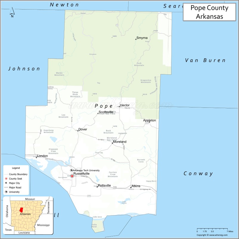
About Pope County Map, Arkansas: The map showing the county boundary, county seat, major cities, highways, water bodies and neighbouring counties.
Related Arkansas & US Links
Map of Pope County, Arkansas
Pope County is a county located in the U.S. state of Arkansas. It's county seat is Russellville. As per 2020 census, the population of Pope County is 63789 people and population density is square miles. According to the United States Census Bureau, the county has a total area of 830.79 sq mi (2,152 km2). Pope County was established on -25625.
Pope County Facts
| Continent | North America |
| Country | United States |
| State | Arkansas |
| County Seat | Russellville |
| Largest City/Town | Russellville |
| Established | November 2, 1829 |
| Total Area | 831 sq mi (2,152 sq km) |
| Land Area | 813 sq mi (2,105 sq km) |
| Water Area | 18 sq mi (47 sq km) |
| Population | 64,754 (Census 2020) |
| Population Density | 79.6 people per sq mi |
| Time Zone | Central Time Zone (CT) |
| Major Highways | Interstate 40, US 64, AR 7, AR 27, AR 124 |
| Major Rivers | Arkansas River, Illinois Bayou |
| Neighboring Counties | Johnson County, Conway County, Yell County, Logan County, Newton County, Searcy County |
| Famous For | Arkansas Tech University, Lake Dardanelle, Mount Nebo, Arkansas River Valley |
| Top Attractions | Lake Dardanelle State Park, Mount Nebo State Park, Arkansas Tech University, Bona Dea Trails |
| Official Website | Official Website |
About Pope County, Arkansas
Pope County is located in north-central Arkansas in the United States and was established in 1829. The county seat is Russellville, which is also the largest city in the county. The county lies in the Arkansas River Valley between the Ozark and Ouachita mountain regions and is known for higher education, outdoor recreation, lakes, and scenic mountain landscapes.
Cities and Towns in Pope County, Arkansas
| City/Town | Population (Census 2020) | Latitude & Longitude |
|---|---|---|
| Russellville (county seat) | 29,338 | 35.2784°N, 93.1338°W |
| Atkins | 2,859 | 35.2462°N, 92.9368°W |
| Dover | 1,337 | 35.4017°N, 93.1143°W |
| Hector | 450 | 35.4681°N, 92.9751°W |
| London | 1,039 | 35.3287°N, 93.2537°W |
| Pottsville | 3,140 | 35.2481°N, 93.0490°W |
| Appleton (CDP) | 81 | 35.6914°N, 93.0279°W |
| Jerusalem (CDP) | 158 | 35.3893°N, 92.8015°W |
| Moreland (CDP) | 115 | 35.3098°N, 93.3804°W |
Golf Courses in Pope County, Arkansas
| Golf Course | Location | Latitude & Longitude |
|---|---|---|
| Russellville Country Club | Russellville | 35.2839°N, 93.1514°W |
| Bay Pointe Golf Club | Russellville | 35.2997°N, 93.1856°W |
| Galla Creek Golf Club | Pottsville | 35.2457°N, 93.0588°W |
Roads and Highways in Pope County, Arkansas
Major highways connect the county to nearby cities and mountain regions.
- Interstate 40 - major east-west interstate connecting Russellville with Little Rock and Fort Smith
- US Highway 64 - regional highway running parallel to Interstate 40 through the Arkansas River Valley
- Arkansas Highway 7 - scenic north-south route connecting the county with the Ozarks and Ouachita Mountains
- Arkansas Highway 27 - connects rural communities and recreation areas
- Arkansas Highway 124 - serves northern Pope County and mountain regions
What Are the Neighboring Counties of Pope County
- Newton County (north)
- Searcy County (northeast)
- Conway County (east)
- Yell County (south)
- Logan County (west)
- Johnson County (northwest)
Whar Are the Top Attractions in Pope County, Arkansas
The county offers a mix of natural and cultural attractions.
- Lake Dardanelle State Park - lakeside park known for fishing, boating, and camping
- Mount Nebo State Park - scenic mountain park with hiking trails and panoramic views
- Arkansas Tech University - major public university located in Russellville
- Bona Dea Trails and Sanctuary - nature preserve with walking trails and wildlife habitats
- Arkansas River - major river popular for fishing and boating recreation
- Old Post Road Recreation Area - outdoor area with trails, camping, and picnic spots
- Russellville Downtown Historic District - historic downtown area with shops and local dining
- Lake Dardanelle - reservoir offering water sports and scenic views
- Holla Bend National Wildlife Refuge nearby - wildlife refuge known for birdwatching and wetlands
- Illinois Bayou Area - scenic natural area popular for kayaking and fishing
- Mount Nebo Scenic Byway - picturesque mountain roadway with overlooks and hiking access
- Atkins Pickle Festival Grounds - site of the county's well-known annual community festival
What is the Distance from Pope County to Nearby Cities
The following distances are measured by road (driving).
- Russellville to Little Rock (Pulaski County), Arkansas - 81 mi (130 km)
- Russellville to Fort Smith (Sebastian County), Arkansas - 82 mi (132 km)
- Russellville to Conway (Faulkner County), Arkansas - 52 mi (84 km)
- Russellville to Fayetteville (Washington County), Arkansas - 109 mi (175 km)
- Russellville to Clarksville (Johnson County), Arkansas - 23 mi (37 km)
- Russellville to Hot Springs (Garland County), Arkansas - 90 mi (145 km)
- Russellville to Morrilton (Conway County), Arkansas - 27 mi (43 km)
- Russellville to Bentonville (Benton County), Arkansas - 130 mi (209 km)
- Russellville to Searcy (White County), Arkansas - 87 mi (140 km)
- Russellville to Mountain View (Stone County), Arkansas - 93 mi (150 km)
- Russellville to Mena (Polk County), Arkansas - 109 mi (175 km)
- Russellville to Pine Bluff (Jefferson County), Arkansas - 118 mi (190 km)
FAQs about Pope County
Pope County is located in north-central Arkansas in the Arkansas River Valley region.
Pope County had a population of 64,754 according to the 2020 United States Census.
Pope County is known for Arkansas Tech University, Lake Dardanelle, Mount Nebo, and outdoor recreation.
The major highways include Interstate 40, US Highway 64, Arkansas Highway 7, Arkansas Highway 27, and Arkansas Highway 124.
Yes, Pope County has several golf facilities including Russellville Country Club and Bay Pointe Golf Club.
References
- QuickFacts - U.S. Census Bureau
- United States Census Bureau
- United States Geological Survey (USGS)
- National Geodetic Survey
- Official County Website
- Arkansas County Map
- Ashley County Map
- Baxter County Map
- Benton County Map
- Boone County Map
- Bradley County Map
- Calhoun County Map
- Carroll County Map
- Chicot County Map
- Clark County Map
- Clay County Map
- Cleburne County Map
- Cleveland County Map
- Columbia County Map
- Conway County Map
- Craighead County Map
- Crawford County Map
- Crittenden County Map
- Cross County Map
- Dallas County Map
- Desha County Map
- Drew County Map
- Faulkner County Map
- Franklin County Map
- Fulton County Map
- Garland County Map
- Grant County Map
- Greene County Map
- Hempstead County Map
- Hot Spring County Map
- Howard County Map
- Independence County Map
- Izard County Map
- Jackson County Map
- Jefferson County Map
- Johnson County Map
- Lafayette County Map
- Lawrence County Map
- Lee County Map
- Lincoln County Map
- Little River County Map
- Logan County Map
- Lonoke County Map
- Madison County Map
- Marion County Map
- Miller County Map
- Mississippi County Map
- Monroe County Map
- Montgomery County Map
- Nevada County Map
- Newton County Map
- Ouachita County Map
- Perry County Map
- Phillips County Map
- Pike County Map
- Poinsett County Map
- Polk County Map
- Pope County Map
- Prairie County Map
- Pulaski County Map
- Randolph County Map
- St Francis County Map
- Saline County Map
- Scott County Map
- Searcy County Map
- Sebastian County Map
- Sevier County Map
- Sharp County Map
- Stone County Map
- Union County Map
- Van Buren County Map
- Washington County Map
- White County Map
- Woodruff County Map
- Yell County Map
- Alabama Counties
- Alaska boroughs
- Arizona Counties
- Arkansas Counties
- California County Map
- Colorado Counties
- Connecticut Counties
- Delaware Counties
- Florida County Map
- Georgia County Map
- Hawaii Counties
- Idaho Counties
- Illinois Counties
- Indiana Counties
- Iowa Counties
- Kansas Counties
- Kentucky Counties
- Louisiana Counties
- Maine Counties
- Maryland Counties
- Massachusetts Counties
- Michigan County Map
- Minnesota Counties
- Mississippi Counties
- Missouri Counties
- Montana Counties
- Nebraska Counties
- Nevada Counties
- New York Counties
- New Hampshire Counties
- New Jersey Counties
- New Mexico Counties
- North Carolina Counties
- North Dakota Counties
- Ohio County Map
- Oklahoma Counties
- Oregon Counties
- Pennsylvania Counties
- Rhode Island Counties
- South Carolina Counties
- South Dakota Counties
- Map of Tennessee
- Texas County Map
- Utah Counties
- Vermont Counties
- Virginia Counties
- Washington Counties
- West Virginia Counties
- Wisconsin Counties
- Wyoming Counties