Written and Fact-checked by Whereig Editors, Reviewed by Mukesh Kumar| Last Updated On: May 10, 2026
Map of Woodruff County - Woodruff County is a county located in the U.S. state of Arkansas. Woodruff County Map showing cities, highways, important places and water bodies. Get Where is Woodruff County located in the map, major cities in Woodruff county, population, areas, and places of interest.
Woodruff County Map, Arkansas
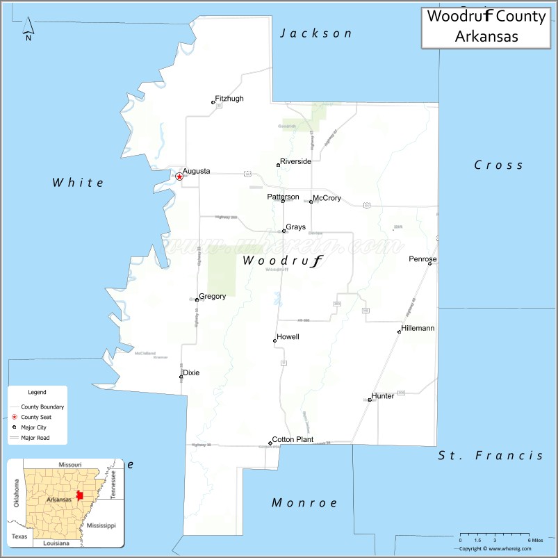
About Woodruff County Map, Arkansas: The map showing the county boundary, county seat, major cities, highways, water bodies and neighbouring counties.
Related Arkansas & US Links
Map of Woodruff County, Arkansas
Woodruff County is a county located in the U.S. state of Arkansas. It's county seat is Augusta. As per 2020 census, the population of Woodruff County is 6116 people and population density is square miles. According to the United States Census Bureau, the county has a total area of 594.05 sq mi (1,539 km2). Woodruff County was established on -13548.
Woodruff County Facts
| Continent | North America |
| Country | United States |
| State | Arkansas |
| County Seat | Augusta |
| Largest City/Town | McCrory |
| Established | November 28, 1862 |
| Total Area | 620 sq mi (1,606 sq km) |
| Land Area | 594 sq mi (1,539 sq km) |
| Water Area | 26 sq mi (67 sq km) |
| Population | 6,269 (Census 2020) |
| Population Density | 10.6 people per sq mi |
| Time Zone | Central Time Zone (CT) |
| Major Highways | US 64, AR 17, AR 33, AR 37, AR 260 |
| Major Rivers | White River, Cache River |
| Neighboring Counties | Jackson County, Cross County, St. Francis County, Monroe County, Prairie County, White County |
| Famous For | Cache River wetlands, agriculture, waterfowl hunting, Delta landscapes |
| Top Attractions | Cache River National Wildlife Refuge, White River, Augusta Historic District, Dagmar Wildlife Management Area |
| Official Website | Official Website |
About Woodruff County, Arkansas
Woodruff County is located in eastern Arkansas in the United States and was established in 1862. The county seat is Augusta, while McCrory is the largest city in the county. The county lies within the Arkansas Delta region and is known for fertile farmland, wetlands, wildlife habitats, waterfowl hunting, and scenic river landscapes.
Cities and Towns in Woodruff County, Arkansas
| City/Town | Population (Census 2020) | Latitude & Longitude |
|---|---|---|
| Augusta (county seat) | 1,908 | 35.2820°N, 91.3651°W |
| McCrory | 1,729 | 35.2565°N, 91.1984°W |
| Cotton Plant | 529 | 35.0051°N, 91.2521°W |
| Gregory | 228 | 35.1265°N, 91.3340°W |
| Patterson | 356 | 35.2620°N, 91.2357°W |
| Hunter | 95 | 35.0487°N, 91.1296°W |
| Howell (CDP) | 74 | 35.2115°N, 91.2784°W |
| Morton (CDP) | 63 | 35.1578°N, 91.4012°W |
Golf Courses in Woodruff County, Arkansas
| Golf Course | Location | Latitude & Longitude |
|---|---|---|
| Augusta Country Club | Augusta | 35.2894°N, 91.3742°W |
| Woodruff County Recreation Golf Area | McCrory | 35.2618°N, 91.2057°W |
Roads and Highways in Woodruff County, Arkansas
Major highways connect the county to eastern Arkansas agricultural and Delta communities.
- US Highway 64 - major east-west route through Augusta and McCrory
- Arkansas Highway 17 - north-south route serving rural communities and wetlands
- Arkansas Highway 33 - regional roadway connecting agricultural areas
- Arkansas Highway 37 - scenic route through Delta farmland and wildlife areas
- Arkansas Highway 260 - local highway serving eastern county communities
What Are the Neighboring Counties of Woodruff County
- Jackson County (north)
- Cross County (northeast)
- St. Francis County (east)
- Monroe County (south)
- Prairie County (southwest)
- White County (west)
Whar Are the Top Attractions in Woodruff County, Arkansas
The county offers a mix of natural and cultural attractions.
- Cache River National Wildlife Refuge - protected wetland area known for birdwatching and wildlife habitats
- White River - scenic river destination for fishing, boating, and outdoor recreation
- Augusta Historic District - historic downtown area with preserved Delta architecture
- Dagmar Wildlife Management Area - popular hunting and wildlife observation destination
- Cache River wetlands - swamp and forest ecosystems supporting migratory birds and wildlife
- Woodruff County Courthouse - historic courthouse building in Augusta
- McCrory Downtown Area - small-town shopping and community district
- Delta farmlands - scenic agricultural landscapes known for rice and soybean production
- Bayou DeView nearby - natural waterway and wildlife viewing destination
- Augusta Riverfront Area - recreation and fishing area along the White River
- Arkansas Delta Scenic Drives - countryside routes through wetlands and farming communities
- Waterfowl hunting lodges and recreation areas - seasonal tourism destinations throughout the county
What is the Distance from Woodruff County to Nearby Cities
The following distances are measured by road (driving).
- Augusta to Little Rock (Pulaski County), Arkansas - 76 mi (122 km)
- Augusta to Jonesboro (Craighead County), Arkansas - 74 mi (119 km)
- Augusta to Searcy (White County), Arkansas - 30 mi (48 km)
- Augusta to Newport (Jackson County), Arkansas - 31 mi (50 km)
- Augusta to Forrest City (St. Francis County), Arkansas - 39 mi (63 km)
- Augusta to Brinkley (Monroe County), Arkansas - 38 mi (61 km)
- Augusta to Memphis (Shelby County), Tennessee - 92 mi (148 km)
- Augusta to Batesville (Independence County), Arkansas - 67 mi (108 km)
- Augusta to Conway (Faulkner County), Arkansas - 88 mi (142 km)
- Augusta to Pine Bluff (Jefferson County), Arkansas - 83 mi (134 km)
- Augusta to Heber Springs (Cleburne County), Arkansas - 65 mi (105 km)
- Augusta to Helena-West Helena (Phillips County), Arkansas - 95 mi (153 km)
FAQs about Woodruff County
Woodruff County is located in eastern Arkansas within the Arkansas Delta region.
Woodruff County had a population of 6,269 according to the 2020 United States Census.
Woodruff County is known for wetlands, agriculture, waterfowl hunting, and the Cache River National Wildlife Refuge.
The major highways include US Highway 64, Arkansas Highway 17, Arkansas Highway 33, Arkansas Highway 37, and Arkansas Highway 260.
Yes, Woodruff County has golf and recreation facilities including Augusta Country Club.
References
- QuickFacts - U.S. Census Bureau
- United States Census Bureau
- United States Geological Survey (USGS)
- National Geodetic Survey
- Official Website
- Arkansas County Map
- Ashley County Map
- Baxter County Map
- Benton County Map
- Boone County Map
- Bradley County Map
- Calhoun County Map
- Carroll County Map
- Chicot County Map
- Clark County Map
- Clay County Map
- Cleburne County Map
- Cleveland County Map
- Columbia County Map
- Conway County Map
- Craighead County Map
- Crawford County Map
- Crittenden County Map
- Cross County Map
- Dallas County Map
- Desha County Map
- Drew County Map
- Faulkner County Map
- Franklin County Map
- Fulton County Map
- Garland County Map
- Grant County Map
- Greene County Map
- Hempstead County Map
- Hot Spring County Map
- Howard County Map
- Independence County Map
- Izard County Map
- Jackson County Map
- Jefferson County Map
- Johnson County Map
- Lafayette County Map
- Lawrence County Map
- Lee County Map
- Lincoln County Map
- Little River County Map
- Logan County Map
- Lonoke County Map
- Madison County Map
- Marion County Map
- Miller County Map
- Mississippi County Map
- Monroe County Map
- Montgomery County Map
- Nevada County Map
- Newton County Map
- Ouachita County Map
- Perry County Map
- Phillips County Map
- Pike County Map
- Poinsett County Map
- Polk County Map
- Pope County Map
- Prairie County Map
- Pulaski County Map
- Randolph County Map
- St Francis County Map
- Saline County Map
- Scott County Map
- Searcy County Map
- Sebastian County Map
- Sevier County Map
- Sharp County Map
- Stone County Map
- Union County Map
- Van Buren County Map
- Washington County Map
- White County Map
- Woodruff County Map
- Yell County Map
- Alabama Counties
- Alaska boroughs
- Arizona Counties
- Arkansas Counties
- California County Map
- Colorado Counties
- Connecticut Counties
- Delaware Counties
- Florida County Map
- Georgia County Map
- Hawaii Counties
- Idaho Counties
- Illinois Counties
- Indiana Counties
- Iowa Counties
- Kansas Counties
- Kentucky Counties
- Louisiana Counties
- Maine Counties
- Maryland Counties
- Massachusetts Counties
- Michigan County Map
- Minnesota Counties
- Mississippi Counties
- Missouri Counties
- Montana Counties
- Nebraska Counties
- Nevada Counties
- New York Counties
- New Hampshire Counties
- New Jersey Counties
- New Mexico Counties
- North Carolina Counties
- North Dakota Counties
- Ohio County Map
- Oklahoma Counties
- Oregon Counties
- Pennsylvania Counties
- Rhode Island Counties
- South Carolina Counties
- South Dakota Counties
- Map of Tennessee
- Texas County Map
- Utah Counties
- Vermont Counties
- Virginia Counties
- Washington Counties
- West Virginia Counties
- Wisconsin Counties
- Wyoming Counties