Written and Fact-checked by Whereig Editors, Reviewed by Mukesh Kumar| Last Updated On: May 10, 2026
Map of Izard County - Izard County is a county located in the U.S. state of Arkansas. Izard County Map showing cities, highways, important places and water bodies. Get Where is Izard County located in the map, major cities in Izard county, population, areas, and places of interest.
Izard County Map, Arkansas
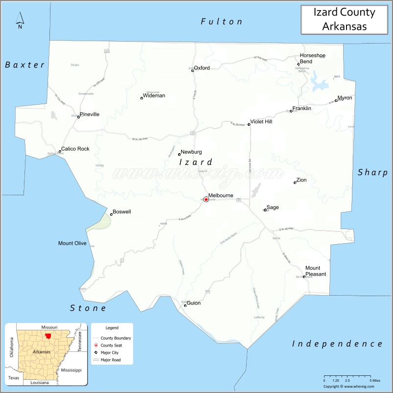
About Izard County Map, Arkansas: The map showing the county boundary, county seat, major cities, highways, water bodies and neighbouring counties.
Related Arkansas & US Links
Map of Izard County, Arkansas
Izard County is a county located in the U.S. state of Arkansas. It's county seat is Melbourne. As per 2020 census, the population of Izard County is 13911 people and population density is square miles. According to the United States Census Bureau, the county has a total area of 584.02 sq mi (1,513 km2). Izard County was established on -27092.
Izard County Facts
| Continent | North America |
| Country | United States |
| State | Arkansas |
| County Seat | Melbourne |
| Largest City/Town | Melbourne |
| Established | 1825 |
| Total Area | 584 sq mi (1,513 sq km) |
| Land Area | 581 sq mi (1,505 sq km) |
| Water Area | 3 sq mi (8 sq km) |
| Population | 13,577 (Census 2020) |
| Population Density | 23.4 people per sq mi |
| Time Zone | Central Time Zone (CST/CDT) |
| Major Highways | US Highway 62, Arkansas Highway 9, Arkansas Highway 56 |
| Major Rivers | White River, Strawberry River |
| Neighboring Counties | Baxter County, Fulton County, Independence County, Sharp County, Stone County |
| Famous For | Ozark Mountain scenery, White River recreation, caves, and rural outdoor tourism |
| Top Attractions | Blanchard Springs Caverns nearby, White River, Melbourne town square, Sylamore Scenic Byway nearby |
| Official Website | Official Website |
About Izard County, Arkansas
Izard County is located in north-central Arkansas in the United States and was established in 1825. The county seat and largest city is Melbourne. Izard County is known for Ozark Mountain landscapes, rivers and caves, scenic drives, and outdoor recreation opportunities throughout the White River region.
Cities and Towns in Izard County, Arkansas
| City/Town | Population (Census 2020) | Latitude & Longitude |
|---|---|---|
| Melbourne (county seat) | 1,848 | 36.0592°N, 91.9074°W |
| Calico Rock | 1,545 | 36.1206°N, 92.1357°W |
| Oxford | 670 | 36.2245°N, 91.9204°W |
| Horseshoe Bend | 2,184 | 36.2234°N, 91.7546°W |
| Brockwell | Rural community | 36.1462°N, 91.9293°W |
| Franklin | Small community | 36.0478°N, 91.8257°W |
| White River region | Outdoor recreation area | 36.1000°N, 92.0500°W |
| Ozark Highlands region | Mountain landscape area | 36.1000°N, 91.9500°W |
Golf Courses in Izard County, Arkansas
| Golf Course | Location | Latitude & Longitude |
|---|---|---|
| Turkey Mountain Golf Course | Horseshoe Bend | 36.2248°N, 91.7524°W |
| Cooper's Hawk Golf Course | Melbourne | 36.0620°N, 91.9102°W |
| Twin Lakes Golf Course | Mountain Home nearby | 36.3365°N, 92.3850°W |
Roads and Highways in Izard County, Arkansas
Major highways connect the county to the Ozark Mountains, White River region, and north Arkansas communities.
- US Highway 62 - major east-west route through northern Arkansas and Ozark communities
- Arkansas Highway 9 - scenic north-south highway through mountain landscapes
- Arkansas Highway 56 - regional route serving rural and river communities
What Are the Neighboring Counties of Izard County
- Baxter County (northwest)
- Fulton County (east)
- Independence County (south)
- Sharp County (east)
- Stone County (west)
Whar Are the Top Attractions in Izard County, Arkansas
The county offers a mix of mountain scenery, river recreation, and outdoor adventures.
- White River recreation - trout fishing, kayaking, canoeing, and boating opportunities
- Historic downtown Melbourne - local restaurants, shops, and community events
- Calico Rock riverfront district - scenic overlooks and Ozark heritage attractions
- Blanchard Springs Caverns nearby - cave tours and underground natural formations
- Sylamore Scenic Byway nearby - mountain drives and forest scenery
- Ozark hiking and camping areas - outdoor recreation and wildlife viewing
- Strawberry River access points - floating, fishing, and swimming activities
- Community fairs and Ozark festivals - celebrations of local traditions and culture
- Nature photography and birdwatching areas - forests, rivers, and mountain habitats
- Historic churches and courthouse sites - regional history and architecture
- Fishing lodges and riverside campgrounds - tourism and family recreation
- Nearby Ozark National Forest access - hiking, camping, and scenic exploration
What is the Distance from Izard County to Nearby Cities
The following distances are measured by road (driving).
- Melbourne to Mountain Home (Baxter County), Arkansas - 53 mi (85 km)
- Melbourne to Batesville (Independence County), Arkansas - 23 mi (37 km)
- Melbourne to Mountain View (Stone County), Arkansas - 28 mi (45 km)
- Melbourne to Jonesboro (Craighead County), Arkansas - 116 mi (187 km)
- Melbourne to Little Rock (Pulaski County), Arkansas - 120 mi (193 km)
- Melbourne to Springfield (Greene County), Missouri - 162 mi (261 km)
- Melbourne to Memphis (Shelby County), Tennessee - 150 mi (241 km)
- Melbourne to St. Louis (St. Louis City), Missouri - 286 mi (460 km)
- Melbourne to Tulsa (Tulsa County), Oklahoma - 283 mi (455 km)
- Melbourne to Nashville (Davidson County), Tennessee - 341 mi (549 km)
- Melbourne to Kansas City (Jackson County), Missouri - 377 mi (607 km)
- Melbourne to Dallas (Dallas County), Texas - 449 mi (723 km)
FAQs about Izard County
Izard County is located in north-central Arkansas in the United States.
The population of Izard County was 13,577 according to the Census 2020.
Izard County is known for Ozark Mountain scenery, White River recreation, caves, and outdoor tourism.
The county is served by US Highway 62, Arkansas Highway 9, and Arkansas Highway 56.
Popular attractions include the White River, nearby Blanchard Springs Caverns, Melbourne town square, and scenic Ozark byways.
References
- QuickFacts - U.S. Census Bureau
- United States Census Bureau
- United States Geological Survey (USGS)
- National Geodetic Survey
- Official Website
- Arkansas County Map
- Ashley County Map
- Baxter County Map
- Benton County Map
- Boone County Map
- Bradley County Map
- Calhoun County Map
- Carroll County Map
- Chicot County Map
- Clark County Map
- Clay County Map
- Cleburne County Map
- Cleveland County Map
- Columbia County Map
- Conway County Map
- Craighead County Map
- Crawford County Map
- Crittenden County Map
- Cross County Map
- Dallas County Map
- Desha County Map
- Drew County Map
- Faulkner County Map
- Franklin County Map
- Fulton County Map
- Garland County Map
- Grant County Map
- Greene County Map
- Hempstead County Map
- Hot Spring County Map
- Howard County Map
- Independence County Map
- Izard County Map
- Jackson County Map
- Jefferson County Map
- Johnson County Map
- Lafayette County Map
- Lawrence County Map
- Lee County Map
- Lincoln County Map
- Little River County Map
- Logan County Map
- Lonoke County Map
- Madison County Map
- Marion County Map
- Miller County Map
- Mississippi County Map
- Monroe County Map
- Montgomery County Map
- Nevada County Map
- Newton County Map
- Ouachita County Map
- Perry County Map
- Phillips County Map
- Pike County Map
- Poinsett County Map
- Polk County Map
- Pope County Map
- Prairie County Map
- Pulaski County Map
- Randolph County Map
- St Francis County Map
- Saline County Map
- Scott County Map
- Searcy County Map
- Sebastian County Map
- Sevier County Map
- Sharp County Map
- Stone County Map
- Union County Map
- Van Buren County Map
- Washington County Map
- White County Map
- Woodruff County Map
- Yell County Map
- Alabama Counties
- Alaska boroughs
- Arizona Counties
- Arkansas Counties
- California County Map
- Colorado Counties
- Connecticut Counties
- Delaware Counties
- Florida County Map
- Georgia County Map
- Hawaii Counties
- Idaho Counties
- Illinois Counties
- Indiana Counties
- Iowa Counties
- Kansas Counties
- Kentucky Counties
- Louisiana Counties
- Maine Counties
- Maryland Counties
- Massachusetts Counties
- Michigan County Map
- Minnesota Counties
- Mississippi Counties
- Missouri Counties
- Montana Counties
- Nebraska Counties
- Nevada Counties
- New York Counties
- New Hampshire Counties
- New Jersey Counties
- New Mexico Counties
- North Carolina Counties
- North Dakota Counties
- Ohio County Map
- Oklahoma Counties
- Oregon Counties
- Pennsylvania Counties
- Rhode Island Counties
- South Carolina Counties
- South Dakota Counties
- Map of Tennessee
- Texas County Map
- Utah Counties
- Vermont Counties
- Virginia Counties
- Washington Counties
- West Virginia Counties
- Wisconsin Counties
- Wyoming Counties