Written and Fact-checked by Whereig Editors, Reviewed by Mukesh Kumar| Last Updated On: May 10, 2026
Map of Cross County - Cross County is a county located in the U.S. state of Arkansas. Cross County Map showing cities, highways, important places and water bodies. Get Where is Cross County located in the map, major cities in Cross county, population, areas, and places of interest.
Cross County Map, Arkansas
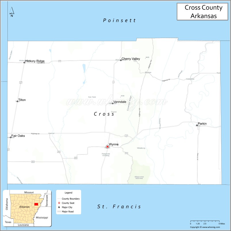
About Cross County Map, Arkansas: The map showing the county boundary, county seat, major cities, highways, water bodies and neighbouring counties.
Related Arkansas & US Links
Map of Cross County, Arkansas
Cross County is a county located in the U.S. state of Arkansas. It's county seat is Wynne. As per 2020 census, the population of Cross County is 16681 people and population density is square miles. According to the United States Census Bureau, the county has a total area of 622.33 sq mi (1,612 km2). Cross County was established on -13559.
Cross County Facts
| Continent | North America |
| Country | United States |
| State | Arkansas |
| County Seat | Wynne |
| Largest City/Town | Wynne |
| Established | 1862 |
| Total Area | 622 sq mi (1,611 sq km) |
| Land Area | 616 sq mi (1,595 sq km) |
| Water Area | 6 sq mi (16 sq km) |
| Population | 16,833 (Census 2020) |
| Population Density | 27.3 people per sq mi |
| Time Zone | Central Time Zone (CST/CDT) |
| Major Highways | Interstate 40, US Highway 64, Arkansas Highway 1 |
| Major Rivers | St. Francis River, L'Anguille River |
| Neighboring Counties | Poinsett County, Crittenden County, St. Francis County, Woodruff County, Jackson County, Craighead County |
| Famous For | Arkansas Delta agriculture, Wynne, railroad history, and Village Creek State Park |
| Top Attractions | Village Creek State Park, Wynne Sports Complex, Delta farmland scenery, railroad heritage sites |
| Official Website | Official Website |
About Cross County, Arkansas
Cross County is located in eastern Arkansas in the United States and was established in 1862. The county seat and largest city is Wynne. Cross County is known for Delta agriculture, railroad history, outdoor recreation, and scenic landscapes surrounding Village Creek State Park and the eastern Arkansas Delta region.
Cities and Towns in Cross County, Arkansas
| City/Town | Population (Census 2020) | Latitude & Longitude |
|---|---|---|
| Wynne (county seat) | 8,314 | 35.2245°N, 90.7868°W |
| Cherry Valley | 651 | 35.4026°N, 90.7543°W |
| Parkin | 794 | 35.2620°N, 90.5629°W |
| Hickory Ridge | 272 | 35.3173°N, 90.9893°W |
| Vanndale | Historic rural community | 35.3120°N, 90.7607°W |
| Tilton | Small community | 35.2508°N, 90.8390°W |
| Village Creek region | Outdoor recreation area | 35.1800°N, 90.7200°W |
| Arkansas Delta region | Agricultural landscape area | 35.2500°N, 90.8000°W |
Golf Courses in Cross County, Arkansas
| Golf Course | Location | Latitude & Longitude |
|---|---|---|
| Wynne Country Club | Wynne | 35.2237°N, 90.7895°W |
| Forrest City Country Club | Forrest City nearby | 35.0188°N, 90.7894°W |
| Sage Meadows Country Club | Jonesboro nearby | 35.8851°N, 90.6625°W |
Roads and Highways in Cross County, Arkansas
Major highways connect the county to Memphis, Little Rock, and the Arkansas Delta agricultural region.
- Interstate 40 - major interstate linking Cross County with Little Rock and Memphis
- US Highway 64 - historic east-west route through Wynne and eastern Arkansas
- Arkansas Highway 1 - regional north-south highway serving Delta farming communities
What Are the Neighboring Counties of Cross County
- Poinsett County (north)
- Crittenden County (east)
- St. Francis County (south)
- Woodruff County (west)
- Jackson County (northwest)
- Craighead County (north)
Whar Are the Top Attractions in Cross County, Arkansas
The county offers a mix of Delta history, outdoor recreation, and community attractions.
- Village Creek State Park - hiking, camping, fishing, and golf opportunities
- Wynne Sports Complex - recreation facilities and community events
- Historic downtown Wynne - local shops, dining, and historic architecture
- Arkansas Delta scenic farmland drives - agricultural landscapes and photography
- Railroad heritage sites in Wynne - reminders of the county’s transportation history
- Village Creek hiking and nature trails - wildlife viewing and outdoor recreation
- Fishing lakes and wetlands areas - birdwatching and nature activities
- Parkin Archaeological State Park nearby - Native American heritage and archaeology exhibits
- Community fairs and Delta festivals - celebrations of local traditions and culture
- St. Francis River recreation access nearby - fishing and boating opportunities
- Historic churches and courthouse district - local heritage landmarks
- Outdoor camping and picnic areas throughout the county - family recreation destinations
What is the Distance from Cross County to Nearby Cities
The following distances are measured by road (driving).
- Wynne to Forrest City (St. Francis County), Arkansas - 18 mi (29 km)
- Wynne to Jonesboro (Craighead County), Arkansas - 46 mi (74 km)
- Wynne to West Memphis (Crittenden County), Arkansas - 52 mi (84 km)
- Wynne to Memphis (Shelby County), Tennessee - 58 mi (93 km)
- Wynne to Batesville (Independence County), Arkansas - 87 mi (140 km)
- Wynne to Little Rock (Pulaski County), Arkansas - 95 mi (153 km)
- Wynne to Jackson (Madison County), Tennessee - 132 mi (212 km)
- Wynne to Nashville (Davidson County), Tennessee - 232 mi (373 km)
- Wynne to St. Louis (St. Louis City), Missouri - 303 mi (488 km)
- Wynne to Tulsa (Tulsa County), Oklahoma - 316 mi (509 km)
- Wynne to Dallas (Dallas County), Texas - 438 mi (705 km)
- Wynne to Kansas City (Jackson County), Missouri - 442 mi (711 km)
FAQs about Cross County
Cross County is located in eastern Arkansas within the Delta region of the United States.
The population of Cross County was 16,833 according to the Census 2020.
Cross County is known for Delta agriculture, Village Creek State Park, railroad history, and outdoor recreation.
The county is served by Interstate 40, US Highway 64, and Arkansas Highway 1.
Popular attractions include Village Creek State Park, Wynne Sports Complex, Delta farmland scenery, and railroad heritage sites.
References
- QuickFacts - U.S. Census Bureau
- United States Census Bureau
- United States Geological Survey (USGS)
- National Geodetic Survey
- Official Website
- Arkansas County Map
- Ashley County Map
- Baxter County Map
- Benton County Map
- Boone County Map
- Bradley County Map
- Calhoun County Map
- Carroll County Map
- Chicot County Map
- Clark County Map
- Clay County Map
- Cleburne County Map
- Cleveland County Map
- Columbia County Map
- Conway County Map
- Craighead County Map
- Crawford County Map
- Crittenden County Map
- Cross County Map
- Dallas County Map
- Desha County Map
- Drew County Map
- Faulkner County Map
- Franklin County Map
- Fulton County Map
- Garland County Map
- Grant County Map
- Greene County Map
- Hempstead County Map
- Hot Spring County Map
- Howard County Map
- Independence County Map
- Izard County Map
- Jackson County Map
- Jefferson County Map
- Johnson County Map
- Lafayette County Map
- Lawrence County Map
- Lee County Map
- Lincoln County Map
- Little River County Map
- Logan County Map
- Lonoke County Map
- Madison County Map
- Marion County Map
- Miller County Map
- Mississippi County Map
- Monroe County Map
- Montgomery County Map
- Nevada County Map
- Newton County Map
- Ouachita County Map
- Perry County Map
- Phillips County Map
- Pike County Map
- Poinsett County Map
- Polk County Map
- Pope County Map
- Prairie County Map
- Pulaski County Map
- Randolph County Map
- St Francis County Map
- Saline County Map
- Scott County Map
- Searcy County Map
- Sebastian County Map
- Sevier County Map
- Sharp County Map
- Stone County Map
- Union County Map
- Van Buren County Map
- Washington County Map
- White County Map
- Woodruff County Map
- Yell County Map
- Alabama Counties
- Alaska boroughs
- Arizona Counties
- Arkansas Counties
- California County Map
- Colorado Counties
- Connecticut Counties
- Delaware Counties
- Florida County Map
- Georgia County Map
- Hawaii Counties
- Idaho Counties
- Illinois Counties
- Indiana Counties
- Iowa Counties
- Kansas Counties
- Kentucky Counties
- Louisiana Counties
- Maine Counties
- Maryland Counties
- Massachusetts Counties
- Michigan County Map
- Minnesota Counties
- Mississippi Counties
- Missouri Counties
- Montana Counties
- Nebraska Counties
- Nevada Counties
- New York Counties
- New Hampshire Counties
- New Jersey Counties
- New Mexico Counties
- North Carolina Counties
- North Dakota Counties
- Ohio County Map
- Oklahoma Counties
- Oregon Counties
- Pennsylvania Counties
- Rhode Island Counties
- South Carolina Counties
- South Dakota Counties
- Map of Tennessee
- Texas County Map
- Utah Counties
- Vermont Counties
- Virginia Counties
- Washington Counties
- West Virginia Counties
- Wisconsin Counties
- Wyoming Counties