Written and Fact-checked by Whereig Editors, Reviewed by Mukesh Kumar| Last Updated On: May 10, 2026
Map of Stone County - Stone County is a county located in the U.S. state of Arkansas. Stone County Map showing cities, highways, important places and water bodies. Get Where is Stone County located in the map, major cities in Stone county, population, areas, and places of interest.
Stone County Map, Arkansas
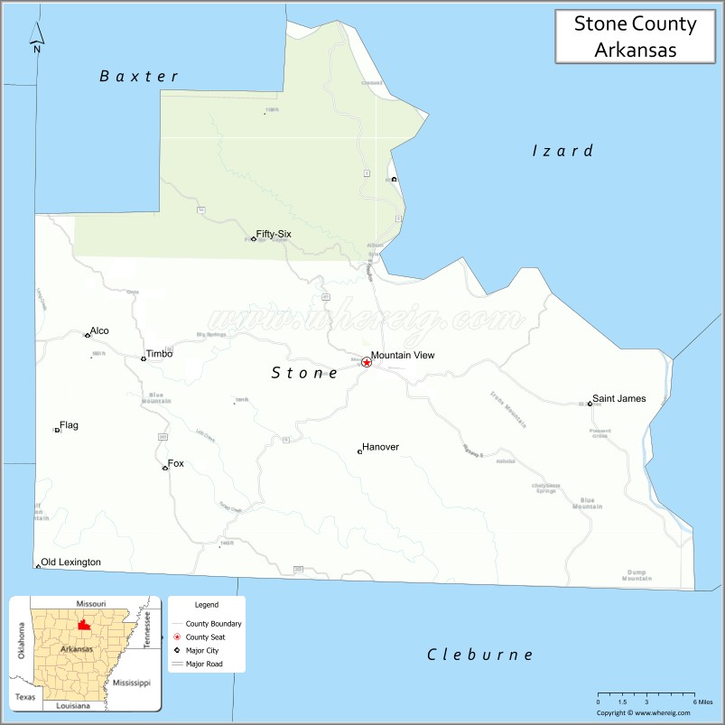
About Stone County Map, Arkansas: The map showing the county boundary, county seat, major cities, highways, water bodies and neighbouring counties.
Related Arkansas & US Links
Map of Stone County, Arkansas
Stone County is a county located in the U.S. state of Arkansas. It's county seat is Mountain View. As per 2020 census, the population of Stone County is 12481 people and population density is square miles. According to the United States Census Bureau, the county has a total area of 609.43 sq mi (1,578 km2). Stone County was established on -9749.
Stone County Facts
| Continent | North America |
| Country | United States |
| State | Arkansas |
| County Seat | Mountain View |
| Largest City/Town | Mountain View |
| Established | April 21, 1873 |
| Total Area | 609 sq mi (1,577 sq km) |
| Land Area | 606 sq mi (1,570 sq km) |
| Water Area | 3 sq mi (7 sq km) |
| Population | 12,359 (Census 2020) |
| Population Density | 20.4 people per sq mi |
| Time Zone | Central Time Zone (CT) |
| Major Highways | US 65, AR 5, AR 9, AR 14, AR 87 |
| Major Rivers | White River, Sylamore Creek |
| Neighboring Counties | Izard County, Baxter County, Independence County, Van Buren County, Searcy County |
| Famous For | Mountain View folk music, Ozark culture, Blanchard Springs Caverns, outdoor recreation |
| Top Attractions | Blanchard Springs Caverns, Ozark Folk Center State Park, White River, Sylamore Scenic Byway |
| Official Website | Official Website |
About Stone County, Arkansas
Stone County is located in north-central Arkansas in the United States and was established in 1873. The county seat is Mountain View, which is also the largest city in the county. The county lies within the Ozark Mountains region and is known for folk music traditions, scenic rivers, caves, forests, and outdoor recreation.
Cities and Towns in Stone County, Arkansas
| City/Town | Population (Census 2020) | Latitude & Longitude |
|---|---|---|
| Mountain View (county seat) | 2,877 | 35.8681°N, 92.1177°W |
| Fifty-Six | 158 | 35.9956°N, 92.2146°W |
| Guion | 68 | 35.9248°N, 91.9455°W |
| Timbo (CDP) | 45 | 35.8446°N, 92.3118°W |
| Newnata (CDP) | 76 | 35.9622°N, 92.0411°W |
| Fox (CDP) | 102 | 35.8469°N, 92.2905°W |
| Optimus (CDP) | 91 | 35.9087°N, 92.0654°W |
Golf Courses in Stone County, Arkansas
| Golf Course | Location | Latitude & Longitude |
|---|---|---|
| Mountain View Country Club | Mountain View | 35.8741°N, 92.1297°W |
| Ozark Highlands Golf Area | Mountain View | 35.8618°N, 92.1086°W |
Roads and Highways in Stone County, Arkansas
Major highways connect the county to Ozark recreation areas and neighboring communities.
- US Highway 65 - major north-south route through the Ozark Mountains
- Arkansas Highway 5 - scenic roadway linking Mountain View with nearby counties
- Arkansas Highway 9 - route connecting rural communities and outdoor destinations
- Arkansas Highway 14 - east-west route serving mountain and river communities
- Arkansas Highway 87 - local roadway providing access to recreation areas and forests
What Are the Neighboring Counties of Stone County
- Baxter County (north)
- Izard County (east)
- Independence County (southeast)
- Van Buren County (south)
- Searcy County (west)
Whar Are the Top Attractions in Stone County, Arkansas
The county offers a mix of natural and cultural attractions.
- Blanchard Springs Caverns - famous limestone cave system with guided underground tours
- Ozark Folk Center State Park - cultural park celebrating Ozark music, crafts, and heritage
- White River - scenic river known for trout fishing, floating, and boating
- Sylamore Scenic Byway - picturesque driving route through forests and mountain landscapes
- Mountain View Courthouse Square - gathering place for live folk music performances and festivals
- Sylamore Creek - clear Ozark stream popular for swimming, kayaking, and camping
- Mirror Lake Waterfall - scenic waterfall and recreation area near Blanchard Springs
- Ozark National Forest nearby - forest recreation area with hiking and wildlife viewing
- Loco Ropes Adventure Park - outdoor climbing and zipline attraction in Mountain View
- Stone County Museum - local museum preserving Ozark history and culture
- Gunner Pool Recreation Area - camping and hiking destination in the national forest
- Jimmy Driftwood Music Barn - music venue honoring the famous folk musician and songwriter
- Mountain View Bluegrass Festivals - annual events celebrating traditional Ozark music
What is the Distance from Stone County to Nearby Cities
The following distances are measured by road (driving).
- Mountain View to Batesville (Independence County), Arkansas - 42 mi (68 km)
- Mountain View to Heber Springs (Cleburne County), Arkansas - 49 mi (79 km)
- Mountain View to Harrison (Boone County), Arkansas - 71 mi (114 km)
- Mountain View to Little Rock (Pulaski County), Arkansas - 95 mi (153 km)
- Mountain View to Searcy (White County), Arkansas - 73 mi (117 km)
- Mountain View to Mountain Home (Baxter County), Arkansas - 52 mi (84 km)
- Mountain View to Conway (Faulkner County), Arkansas - 84 mi (135 km)
- Mountain View to Jonesboro (Craighead County), Arkansas - 121 mi (195 km)
- Mountain View to Branson (Taney County), Missouri - 113 mi (182 km)
- Mountain View to Russellville (Pope County), Arkansas - 103 mi (166 km)
- Mountain View to Clinton (Van Buren County), Arkansas - 37 mi (60 km)
- Mountain View to Memphis (Shelby County), Tennessee - 176 mi (283 km)
FAQs about Stone County
Stone County is located in north-central Arkansas within the Ozark Mountains region.
Stone County had a population of 12,359 according to the 2020 United States Census.
Stone County is known for Mountain View folk music traditions, Blanchard Springs Caverns, and Ozark outdoor recreation.
The major highways include US Highway 65, Arkansas Highway 5, Arkansas Highway 9, Arkansas Highway 14, and Arkansas Highway 87.
Yes, Stone County has golf facilities including Mountain View Country Club and local recreation golf areas.
References
- QuickFacts - U.S. Census Bureau
- United States Census Bureau
- United States Geological Survey (USGS)
- National Geodetic Survey
- Official Website
- Arkansas County Map
- Ashley County Map
- Baxter County Map
- Benton County Map
- Boone County Map
- Bradley County Map
- Calhoun County Map
- Carroll County Map
- Chicot County Map
- Clark County Map
- Clay County Map
- Cleburne County Map
- Cleveland County Map
- Columbia County Map
- Conway County Map
- Craighead County Map
- Crawford County Map
- Crittenden County Map
- Cross County Map
- Dallas County Map
- Desha County Map
- Drew County Map
- Faulkner County Map
- Franklin County Map
- Fulton County Map
- Garland County Map
- Grant County Map
- Greene County Map
- Hempstead County Map
- Hot Spring County Map
- Howard County Map
- Independence County Map
- Izard County Map
- Jackson County Map
- Jefferson County Map
- Johnson County Map
- Lafayette County Map
- Lawrence County Map
- Lee County Map
- Lincoln County Map
- Little River County Map
- Logan County Map
- Lonoke County Map
- Madison County Map
- Marion County Map
- Miller County Map
- Mississippi County Map
- Monroe County Map
- Montgomery County Map
- Nevada County Map
- Newton County Map
- Ouachita County Map
- Perry County Map
- Phillips County Map
- Pike County Map
- Poinsett County Map
- Polk County Map
- Pope County Map
- Prairie County Map
- Pulaski County Map
- Randolph County Map
- St Francis County Map
- Saline County Map
- Scott County Map
- Searcy County Map
- Sebastian County Map
- Sevier County Map
- Sharp County Map
- Stone County Map
- Union County Map
- Van Buren County Map
- Washington County Map
- White County Map
- Woodruff County Map
- Yell County Map
- Alabama Counties
- Alaska boroughs
- Arizona Counties
- Arkansas Counties
- California County Map
- Colorado Counties
- Connecticut Counties
- Delaware Counties
- Florida County Map
- Georgia County Map
- Hawaii Counties
- Idaho Counties
- Illinois Counties
- Indiana Counties
- Iowa Counties
- Kansas Counties
- Kentucky Counties
- Louisiana Counties
- Maine Counties
- Maryland Counties
- Massachusetts Counties
- Michigan County Map
- Minnesota Counties
- Mississippi Counties
- Missouri Counties
- Montana Counties
- Nebraska Counties
- Nevada Counties
- New York Counties
- New Hampshire Counties
- New Jersey Counties
- New Mexico Counties
- North Carolina Counties
- North Dakota Counties
- Ohio County Map
- Oklahoma Counties
- Oregon Counties
- Pennsylvania Counties
- Rhode Island Counties
- South Carolina Counties
- South Dakota Counties
- Map of Tennessee
- Texas County Map
- Utah Counties
- Vermont Counties
- Virginia Counties
- Washington Counties
- West Virginia Counties
- Wisconsin Counties
- Wyoming Counties