Written and Fact-checked by Whereig Editors, Reviewed by Mukesh Kumar| Last Updated On: May 10, 2026
Map of Franklin County - Franklin County is a county located in the U.S. state of Arkansas. Franklin County Map showing cities, highways, important places and water bodies. Get Where is Franklin County located in the map, major cities in Franklin county, population, areas, and places of interest.
Franklin County Map, Arkansas
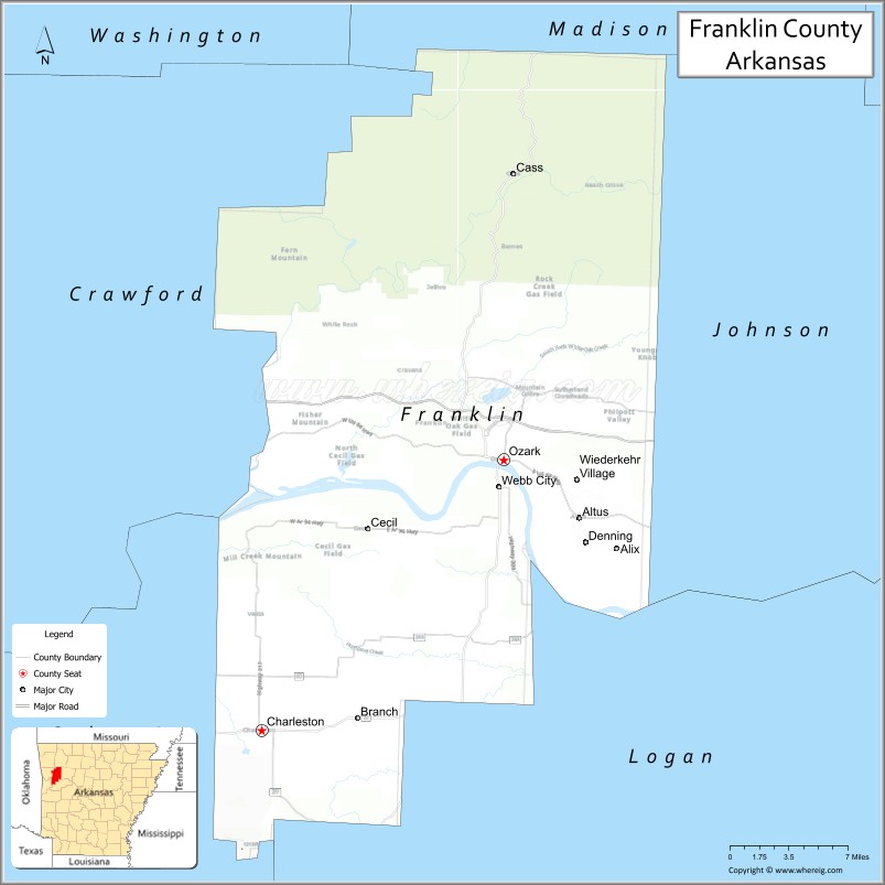
About Franklin County Map, Arkansas: The map showing the county boundary, county seat, major cities, highways, water bodies and neighbouring counties.
Related Arkansas & US Links
Map of Franklin County, Arkansas
"Franklin County is a county located in the U.S. state of Arkansas. It's county seat is Ozark, Charleston. As per 2020 census, the population of Franklin County is 17173 people and population density is square miles. According to the United States Census Bureau, the county has a total area of 619.69 sq mi (1,605 km2). Franklin County was established on -22656."
Franklin County Facts
| Continent | North America |
| Country | United States |
| State | Arkansas |
| County Seats | Ozark and Charleston |
| Largest City/Town | Ozark |
| Established | 1837 |
| Total Area | 635 sq mi (1,645 sq km) |
| Land Area | 609 sq mi (1,577 sq km) |
| Water Area | 26 sq mi (67 sq km) |
| Population | 17,097 (Census 2020) |
| Population Density | 28.1 people per sq mi |
| Time Zone | Central Time Zone (CST/CDT) |
| Major Highways | Interstate 40, US Highway 64, Arkansas Highway 23 |
| Major Rivers | Arkansas River, Mulberry River |
| Neighboring Counties | Crawford County, Johnson County, Logan County, Madison County, Sebastian County |
| Famous For | Ozark Mountains scenery, Arkansas wine country, Mulberry River recreation, and outdoor tourism |
| Top Attractions | Ozark National Forest, Mulberry River, Wiederkehr Village wineries, Mount Magazine nearby |
| Official Website | Official Website |
About Franklin County, Arkansas
Franklin County is located in western Arkansas in the United States and was established in 1837. The county has two county seats, Ozark and Charleston. Franklin County is known for scenic mountain landscapes, Arkansas wine country, river recreation, and outdoor adventures in the Ozark Mountains region.
Cities and Towns in Franklin County, Arkansas
| City/Town | Population (Census 2020) | Latitude & Longitude |
|---|---|---|
| Ozark (county seat) | 3,368 | 35.4870°N, 93.8277°W |
| Charleston (county seat) | 2,497 | 35.2984°N, 94.0366°W |
| Altus | 758 | 35.4484°N, 93.7380°W |
| Branch | 375 | 35.3051°N, 93.9491°W |
| Denning | 270 | 35.4106°N, 93.7166°W |
| Wiederkehr Village | 38 | 35.4615°N, 93.7430°W |
| Mulberry River region | Outdoor recreation area | 35.5400°N, 93.8500°W |
| Ozark National Forest region | Mountain landscape area | 35.5000°N, 93.9000°W |
Golf Courses in Franklin County, Arkansas
| Golf Course | Location | Latitude & Longitude |
|---|---|---|
| Ozark Country Club | Ozark | 35.4895°N, 93.8312°W |
| Paris Golf Course | Paris nearby | 35.2928°N, 93.7251°W |
| Hardscrabble Country Club | Fort Smith nearby | 35.3857°N, 94.3839°W |
Roads and Highways in Franklin County, Arkansas
Major highways connect the county to western Arkansas, the Ozark Mountains, and the Arkansas River Valley.
- Interstate 40 - major interstate linking Franklin County with Fort Smith and Little Rock
- US Highway 64 - historic route through Ozark and the Arkansas River Valley
- Arkansas Highway 23 - scenic Pig Trail route through the Ozark Mountains
What Are the Neighboring Counties of Franklin County
- Crawford County (west)
- Johnson County (north)
- Logan County (south)
- Madison County (northeast)
- Sebastian County (southwest)
Whar Are the Top Attractions in Franklin County, Arkansas
The county offers a mix of mountain recreation, wineries, and scenic outdoor attractions.
- Ozark National Forest - hiking, camping, waterfalls, and wildlife viewing
- Mulberry River - canoeing, kayaking, fishing, and floating adventures
- Wiederkehr Wine Cellars - historic Arkansas winery and tasting destination
- Mount Magazine nearby - Arkansas’s highest peak with scenic overlooks
- Altus wine country - vineyards, wineries, and mountain scenery
- Pig Trail Scenic Byway - famous mountain drive through forest landscapes
- Historic downtown Ozark - local shops, dining, and Arkansas River views
- Charleston historic district - heritage buildings and community attractions
- Arkansas River recreation areas - boating, fishing, and camping opportunities
- Ozark Highlands hiking areas - scenic trails and outdoor photography
- Community festivals and wine events - celebrations of regional culture and traditions
- Nature observation and birdwatching sites - forest and river habitats
What is the Distance from Franklin County to Nearby Cities
The following distances are measured by road (driving).
- Ozark to Fort Smith (Sebastian County), Arkansas - 38 mi (61 km)
- Ozark to Russellville (Pope County), Arkansas - 46 mi (74 km)
- Ozark to Fayetteville (Washington County), Arkansas - 79 mi (127 km)
- Ozark to Little Rock (Pulaski County), Arkansas - 124 mi (200 km)
- Ozark to Tulsa (Tulsa County), Oklahoma - 135 mi (217 km)
- Ozark to Springfield (Greene County), Missouri - 167 mi (269 km)
- Ozark to Oklahoma City (Oklahoma County), Oklahoma - 205 mi (330 km)
- Ozark to Memphis (Shelby County), Tennessee - 266 mi (428 km)
- Ozark to Kansas City (Jackson County), Missouri - 279 mi (449 km)
- Ozark to Dallas (Dallas County), Texas - 321 mi (517 km)
- Ozark to St. Louis (St. Louis City), Missouri - 355 mi (571 km)
- Ozark to Nashville (Davidson County), Tennessee - 463 mi (745 km)
FAQs about Franklin County
Franklin County is located in western Arkansas within the Ozark Mountains region of the United States.
The population of Franklin County was 17,097 according to the Census 2020.
Franklin County is known for Ozark Mountain scenery, Arkansas wineries, the Mulberry River, and outdoor recreation.
The county is served by Interstate 40, US Highway 64, and Arkansas Highway 23.
Popular attractions include the Ozark National Forest, Mulberry River, Wiederkehr Village wineries, and nearby Mount Magazine.
References
- QuickFacts - U.S. Census Bureau
- United States Census Bureau
- United States Geological Survey (USGS)
- National Geodetic Survey
- Official Website
- Arkansas County Map
- Ashley County Map
- Baxter County Map
- Benton County Map
- Boone County Map
- Bradley County Map
- Calhoun County Map
- Carroll County Map
- Chicot County Map
- Clark County Map
- Clay County Map
- Cleburne County Map
- Cleveland County Map
- Columbia County Map
- Conway County Map
- Craighead County Map
- Crawford County Map
- Crittenden County Map
- Cross County Map
- Dallas County Map
- Desha County Map
- Drew County Map
- Faulkner County Map
- Franklin County Map
- Fulton County Map
- Garland County Map
- Grant County Map
- Greene County Map
- Hempstead County Map
- Hot Spring County Map
- Howard County Map
- Independence County Map
- Izard County Map
- Jackson County Map
- Jefferson County Map
- Johnson County Map
- Lafayette County Map
- Lawrence County Map
- Lee County Map
- Lincoln County Map
- Little River County Map
- Logan County Map
- Lonoke County Map
- Madison County Map
- Marion County Map
- Miller County Map
- Mississippi County Map
- Monroe County Map
- Montgomery County Map
- Nevada County Map
- Newton County Map
- Ouachita County Map
- Perry County Map
- Phillips County Map
- Pike County Map
- Poinsett County Map
- Polk County Map
- Pope County Map
- Prairie County Map
- Pulaski County Map
- Randolph County Map
- St Francis County Map
- Saline County Map
- Scott County Map
- Searcy County Map
- Sebastian County Map
- Sevier County Map
- Sharp County Map
- Stone County Map
- Union County Map
- Van Buren County Map
- Washington County Map
- White County Map
- Woodruff County Map
- Yell County Map
- Alabama Counties
- Alaska boroughs
- Arizona Counties
- Arkansas Counties
- California County Map
- Colorado Counties
- Connecticut Counties
- Delaware Counties
- Florida County Map
- Georgia County Map
- Hawaii Counties
- Idaho Counties
- Illinois Counties
- Indiana Counties
- Iowa Counties
- Kansas Counties
- Kentucky Counties
- Louisiana Counties
- Maine Counties
- Maryland Counties
- Massachusetts Counties
- Michigan County Map
- Minnesota Counties
- Mississippi Counties
- Missouri Counties
- Montana Counties
- Nebraska Counties
- Nevada Counties
- New York Counties
- New Hampshire Counties
- New Jersey Counties
- New Mexico Counties
- North Carolina Counties
- North Dakota Counties
- Ohio County Map
- Oklahoma Counties
- Oregon Counties
- Pennsylvania Counties
- Rhode Island Counties
- South Carolina Counties
- South Dakota Counties
- Map of Tennessee
- Texas County Map
- Utah Counties
- Vermont Counties
- Virginia Counties
- Washington Counties
- West Virginia Counties
- Wisconsin Counties
- Wyoming Counties