Written and Fact-checked by Whereig Editors, Reviewed by Mukesh Kumar| Last Updated On: May 10, 2026
Map of Lee County - Lee County is a county located in the U.S. state of Arkansas. Lee County Map showing cities, highways, important places and water bodies. Get Where is Lee County located in the map, major cities in Lee county, population, areas, and places of interest.
Lee County Map, Arkansas
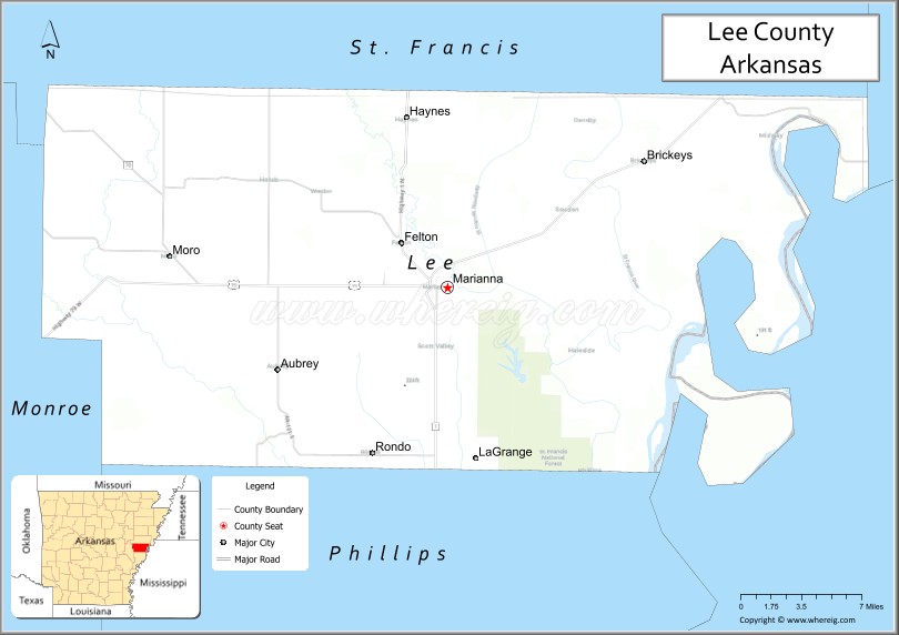
About Lee County Map, Arkansas: The map showing the county boundary, county seat, major cities, highways, water bodies and neighbouring counties.
Related Arkansas & US Links
Map of Lee County, Arkansas
Lee County is a county located in the U.S. state of Arkansas. It's county seat is Marianna. As per 2020 census, the population of Lee County is 8619 people and population density is square miles. According to the United States Census Bureau, the county has a total area of 619.47 sq mi (1,604 km2). Lee County was established on -9753.
Lee County Facts
| Continent | North America |
| Country | United States |
| State | Arkansas |
| County Seat | Marianna |
| Largest City/Town | Marianna |
| Established | 1873 |
| Total Area | 620 sq mi (1,606 sq km) |
| Land Area | 603 sq mi (1,562 sq km) |
| Water Area | 17 sq mi (44 sq km) |
| Population | 8,835 (Census 2020) |
| Population Density | 14.7 people per sq mi |
| Time Zone | Central Time Zone (CST/CDT) |
| Major Highways | US Highway 79, Arkansas Highway 1, Arkansas Highway 44 |
| Major Rivers | Mississippi River watershed, L'Anguille River, St. Francis River nearby |
| Neighboring Counties | Crittenden County, Monroe County, Phillips County, St. Francis County |
| Famous For | Arkansas Delta agriculture, Civil Rights history, blues heritage, and Crowley’s Ridge scenery |
| Top Attractions | Marianna Commercial Historic District, Bear Creek Lake, Delta cultural sites, Mississippi Delta landscapes |
| Official Website | Official Website |
About Lee County, Arkansas
Lee County is located in eastern Arkansas in the United States and was established in 1873. The county seat and largest city is Marianna. Lee County is known for its agricultural economy, Delta culture, Civil Rights history, blues traditions, and scenic landscapes along Crowley’s Ridge and the Mississippi Delta.
Cities and Towns in Lee County, Arkansas
| City/Town | Population (Census 2020) | Latitude & Longitude |
|---|---|---|
| Marianna (county seat) | 3,477 | 34.7737°N, 90.7576°W |
| Aubrey | 170 | 34.7187°N, 90.8976°W |
| Haynes | 121 | 34.8843°N, 90.7932°W |
| LaGrange | Historic community | 34.6570°N, 90.7388°W |
| Brickeys | Small rural community | 34.8134°N, 90.6182°W |
| Palestine nearby region | Delta landscape area | 34.9700°N, 90.9000°W |
| Bear Creek Lake region | Outdoor recreation area | 34.7800°N, 90.7400°W |
| Arkansas Delta farmland region | Agricultural landscape area | 34.8000°N, 90.8000°W |
Golf Courses in Lee County, Arkansas
| Golf Course | Location | Latitude & Longitude |
|---|---|---|
| Forrest City Country Club | Forrest City nearby | 35.0132°N, 90.7896°W |
| Indian Hills Golf Course | West Helena nearby | 34.5485°N, 90.6414°W |
| Sage Meadows Country Club | Jonesboro nearby | 35.8851°N, 90.6625°W |
Roads and Highways in Lee County, Arkansas
Major highways connect the county to the Arkansas Delta, Memphis, and central Arkansas communities.
- US Highway 79 - major transportation corridor through eastern Arkansas
- Arkansas Highway 1 - north-south route serving Delta agricultural communities
- Arkansas Highway 44 - regional highway linking rural towns and farmland areas
What Are the Neighboring Counties of Lee County
- Crittenden County (north)
- Monroe County (southwest)
- Phillips County (south)
- St. Francis County (northwest)
Whar Are the Top Attractions in Lee County, Arkansas
The county offers a mix of Delta culture, historical landmarks, and outdoor recreation.
- Marianna Commercial Historic District - historic buildings, local shops, and cultural heritage
- Bear Creek Lake recreation area - fishing, boating, camping, and picnicking
- Delta blues and cultural heritage sites - music history and Arkansas traditions
- Crowley’s Ridge scenic landscapes nearby - nature photography and sightseeing
- Historic churches and Civil Rights landmarks - regional historical significance
- Arkansas Delta scenic drives - farmland, wetlands, and countryside views
- Community festivals and cultural events - celebrations of local traditions and heritage
- Wildlife observation and birdwatching areas - wetlands and river habitats
- Fishing and hunting opportunities throughout the county - outdoor recreation destinations
- Historic courthouse and downtown Marianna district - architecture and local history
- Nearby Mississippi River Delta attractions access - regional tourism and recreation
- Nature trails and picnic areas - family-friendly outdoor activities
What is the Distance from Lee County to Nearby Cities
The following distances are measured by road (driving).
- Marianna to Forrest City (St. Francis County), Arkansas - 21 mi (34 km)
- Marianna to Helena-West Helena (Phillips County), Arkansas - 49 mi (79 km)
- Marianna to Memphis (Shelby County), Tennessee - 62 mi (100 km)
- Marianna to Jonesboro (Craighead County), Arkansas - 89 mi (143 km)
- Marianna to Little Rock (Pulaski County), Arkansas - 98 mi (158 km)
- Marianna to Jackson (Madison County), Tennessee - 143 mi (230 km)
- Marianna to Tupelo (Lee County), Mississippi - 126 mi (203 km)
- Marianna to St. Louis (St. Louis City), Missouri - 296 mi (476 km)
- Marianna to Nashville (Davidson County), Tennessee - 247 mi (398 km)
- Marianna to Birmingham (Jefferson County), Alabama - 278 mi (447 km)
- Marianna to Dallas (Dallas County), Texas - 446 mi (718 km)
- Marianna to New Orleans (Orleans Parish), Louisiana - 405 mi (652 km)
FAQs about Lee County
Lee County is located in eastern Arkansas in the United States.
The population of Lee County was 8,835 according to the Census 2020.
Lee County is known for Delta agriculture, Civil Rights history, blues culture, and Crowley’s Ridge scenery.
The county is served by US Highway 79, Arkansas Highway 1, and Arkansas Highway 44.
Popular attractions include the Marianna Commercial Historic District, Bear Creek Lake, Delta cultural heritage sites, and scenic Arkansas Delta landscapes.
References
- QuickFacts - U.S. Census Bureau
- United States Census Bureau
- United States Geological Survey (USGS)
- National Geodetic Survey
- Official Website
- Arkansas County Map
- Ashley County Map
- Baxter County Map
- Benton County Map
- Boone County Map
- Bradley County Map
- Calhoun County Map
- Carroll County Map
- Chicot County Map
- Clark County Map
- Clay County Map
- Cleburne County Map
- Cleveland County Map
- Columbia County Map
- Conway County Map
- Craighead County Map
- Crawford County Map
- Crittenden County Map
- Cross County Map
- Dallas County Map
- Desha County Map
- Drew County Map
- Faulkner County Map
- Franklin County Map
- Fulton County Map
- Garland County Map
- Grant County Map
- Greene County Map
- Hempstead County Map
- Hot Spring County Map
- Howard County Map
- Independence County Map
- Izard County Map
- Jackson County Map
- Jefferson County Map
- Johnson County Map
- Lafayette County Map
- Lawrence County Map
- Lee County Map
- Lincoln County Map
- Little River County Map
- Logan County Map
- Lonoke County Map
- Madison County Map
- Marion County Map
- Miller County Map
- Mississippi County Map
- Monroe County Map
- Montgomery County Map
- Nevada County Map
- Newton County Map
- Ouachita County Map
- Perry County Map
- Phillips County Map
- Pike County Map
- Poinsett County Map
- Polk County Map
- Pope County Map
- Prairie County Map
- Pulaski County Map
- Randolph County Map
- St Francis County Map
- Saline County Map
- Scott County Map
- Searcy County Map
- Sebastian County Map
- Sevier County Map
- Sharp County Map
- Stone County Map
- Union County Map
- Van Buren County Map
- Washington County Map
- White County Map
- Woodruff County Map
- Yell County Map
- Alabama Counties
- Alaska boroughs
- Arizona Counties
- Arkansas Counties
- California County Map
- Colorado Counties
- Connecticut Counties
- Delaware Counties
- Florida County Map
- Georgia County Map
- Hawaii Counties
- Idaho Counties
- Illinois Counties
- Indiana Counties
- Iowa Counties
- Kansas Counties
- Kentucky Counties
- Louisiana Counties
- Maine Counties
- Maryland Counties
- Massachusetts Counties
- Michigan County Map
- Minnesota Counties
- Mississippi Counties
- Missouri Counties
- Montana Counties
- Nebraska Counties
- Nevada Counties
- New York Counties
- New Hampshire Counties
- New Jersey Counties
- New Mexico Counties
- North Carolina Counties
- North Dakota Counties
- Ohio County Map
- Oklahoma Counties
- Oregon Counties
- Pennsylvania Counties
- Rhode Island Counties
- South Carolina Counties
- South Dakota Counties
- Map of Tennessee
- Texas County Map
- Utah Counties
- Vermont Counties
- Virginia Counties
- Washington Counties
- West Virginia Counties
- Wisconsin Counties
- Wyoming Counties