Written and Fact-checked by Whereig Editors, Reviewed by Mukesh Kumar| Last Updated On: May 10, 2026
Map of Benton County - Benton County is a county located in the U.S. state of Arkansas. Benton County Map showing cities, highways, important places and water bodies. Get Where is Benton County located in the map, major cities in Benton county, population, areas, and places of interest.
Benton County Map, Arkansas
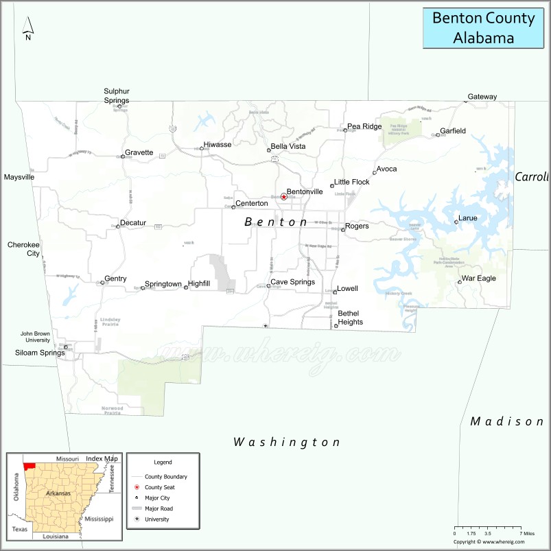
About Benton County Map, Arkansas: The map showing the county boundary, county seat, major cities, highways, water bodies and neighbouring counties.
Related Arkansas & US Links
Map of Benton County, Arkansas
Benton County is a county located in the U.S. state of Arkansas. It's county seat is Bentonville. As per 2020 census, the population of Benton County is 293692 people and population density is square miles. According to the United States Census Bureau, the county has a total area of 884.86 sq mi (2,292 km2). Benton County was established on -23101.
Benton County Facts
| Continent | North America |
| Country | United States |
| State | Arkansas |
| County Seat | Bentonville |
| Largest City/Town | Rogers |
| Established | 1836 |
| Total Area | 884 sq mi (2,290 sq km) |
| Land Area | 847 sq mi (2,194 sq km) |
| Water Area | 37 sq mi (96 sq km) |
| Population | 284,333 (Census 2020) |
| Population Density | 335.7 people per sq mi |
| Time Zone | Central Time Zone (CST/CDT) |
| Major Highways | Interstate 49, US Highway 71, US Highway 62, Arkansas Highway 12 |
| Major Rivers | White River, Illinois River |
| Neighboring Counties | Washington County, Carroll County, Madison County, Delaware County (OK), McDonald County (MO) |
| Famous For | Walmart headquarters, Crystal Bridges Museum, Northwest Arkansas growth, and Beaver Lake |
| Top Attractions | Crystal Bridges Museum of American Art, Beaver Lake, Walmart Museum, Pea Ridge National Military Park |
| Official Website | Official Website |
About Benton County, Arkansas
Benton County is located in northwestern Arkansas in the United States and was established in 1836. The county seat is Bentonville, while Rogers is the largest city. Benton County is known for rapid economic growth, corporate headquarters, outdoor recreation, arts and culture, and scenic Ozark Mountain landscapes.
Cities and Towns in Benton County, Arkansas
| City/Town | Population (Census 2020) | Latitude & Longitude |
|---|---|---|
| Rogers | 69,908 | 36.3320°N, 94.1185°W |
| Bentonville (county seat) | 54,164 | 36.3729°N, 94.2088°W |
| Bella Vista | 30,104 | 36.4814°N, 94.2730°W |
| Siloam Springs | 17,287 | 36.1881°N, 94.5405°W |
| Centerton | 16,244 | 36.3595°N, 94.2852°W |
| Pea Ridge | 6,403 | 36.4534°N, 94.1152°W |
| Gravette | 3,547 | 36.4229°N, 94.4538°W |
| Lowell | 9,839 | 36.2556°N, 94.1344°W |
| Cave Springs | 5,495 | 36.2665°N, 94.2316°W |
| Decatur | 1,699 | 36.3356°N, 94.4608°W |
| Gentry | 3,679 | 36.2679°N, 94.4841°W |
| Little Flock | 3,197 | 36.3784°N, 94.1455°W |
Golf Courses in Benton County, Arkansas
| Golf Course | Location | Latitude & Longitude |
|---|---|---|
| Pinnacle Country Club | Rogers | 36.3183°N, 94.1739°W |
| Bella Vista Country Club | Bella Vista | 36.4817°N, 94.2792°W |
| Lost Springs Golf & Athletic Club | Rogers | 36.3319°N, 94.1689°W |
| Scotsdale Golf Course | Bella Vista | 36.4869°N, 94.2942°W |
Roads and Highways in Benton County, Arkansas
Major highways connect the county to Northwest Arkansas, Missouri, Oklahoma, and regional business centers.
- Interstate 49 - major north-south interstate linking Benton County with Fayetteville, Fort Smith, and Missouri
- US Highway 71 - regional highway serving Bentonville, Rogers, and surrounding communities
- US Highway 62 - east-west route connecting Northwest Arkansas towns and recreation areas
- Arkansas Highway 12 - scenic route connecting Beaver Lake and Ozark Mountain regions
What Are the Neighboring Counties of Benton County
- Washington County (south)
- Carroll County (east)
- Madison County (southeast)
- Delaware County, Oklahoma (west)
- McDonald County, Missouri (north)
Whar Are the Top Attractions in Benton County, Arkansas
The county offers a mix of arts, business tourism, outdoor recreation, and Ozark Mountain attractions.
- Crystal Bridges Museum of American Art - nationally recognized art museum in Bentonville
- Walmart Museum - exhibits on the history of Walmart and founder Sam Walton
- Beaver Lake - boating, fishing, swimming, and lakeside recreation destination
- Pea Ridge National Military Park - preserved Civil War battlefield and historic trails
- Downtown Bentonville Square - restaurants, shopping, museums, and community events
- Scott Family Amazeum - interactive children’s museum and family attraction
- Slaughter Pen Mountain Bike Trails - internationally known biking trail system
- Hobbs State Park-Conservation Area - hiking, camping, and wildlife viewing
- War Eagle Mill nearby - historic working grist mill and scenic Ozark landmark
- Rogers Historic District - local culture, dining, and entertainment attractions
- Northwest Arkansas Razorback Greenway - regional biking and walking trail network
- Bella Vista outdoor recreation areas - golf, lakes, and Ozark Mountain scenery
What is the Distance from Benton County to Nearby Cities
The following distances are measured by road (driving).
- Bentonville to Fayetteville (Washington County), Arkansas - 28 mi (45 km)
- Bentonville to Springdale (Washington County), Arkansas - 21 mi (34 km)
- Bentonville to Fort Smith (Sebastian County), Arkansas - 87 mi (140 km)
- Bentonville to Tulsa (Tulsa County), Oklahoma - 116 mi (187 km)
- Bentonville to Springfield (Greene County), Missouri - 133 mi (214 km)
- Bentonville to Little Rock (Pulaski County), Arkansas - 212 mi (341 km)
- Bentonville to Kansas City (Jackson County), Missouri - 223 mi (359 km)
- Bentonville to Oklahoma City (Oklahoma County), Oklahoma - 233 mi (375 km)
- Bentonville to Memphis (Shelby County), Tennessee - 327 mi (526 km)
- Bentonville to St. Louis (St. Louis City), Missouri - 346 mi (557 km)
- Bentonville to Dallas (Dallas County), Texas - 364 mi (586 km)
- Bentonville to Nashville (Davidson County), Tennessee - 474 mi (763 km)
FAQs about Benton County
Benton County is located in northwestern Arkansas within the Ozark Mountain region of the United States.
The population of Benton County was 284,333 according to the Census 2020.
Benton County is known for Walmart headquarters, Crystal Bridges Museum, Beaver Lake, and rapid growth in Northwest Arkansas.
The county is served by Interstate 49, US Highway 71, US Highway 62, and Arkansas Highway 12.
Popular attractions include Crystal Bridges Museum of American Art, Beaver Lake, the Walmart Museum, and Pea Ridge National Military Park.
References
- QuickFacts - U.S. Census Bureau
- United States Census Bureau
- United States Geological Survey (USGS)
- National Geodetic Survey
- Official Website
- Arkansas County Map
- Ashley County Map
- Baxter County Map
- Benton County Map
- Boone County Map
- Bradley County Map
- Calhoun County Map
- Carroll County Map
- Chicot County Map
- Clark County Map
- Clay County Map
- Cleburne County Map
- Cleveland County Map
- Columbia County Map
- Conway County Map
- Craighead County Map
- Crawford County Map
- Crittenden County Map
- Cross County Map
- Dallas County Map
- Desha County Map
- Drew County Map
- Faulkner County Map
- Franklin County Map
- Fulton County Map
- Garland County Map
- Grant County Map
- Greene County Map
- Hempstead County Map
- Hot Spring County Map
- Howard County Map
- Independence County Map
- Izard County Map
- Jackson County Map
- Jefferson County Map
- Johnson County Map
- Lafayette County Map
- Lawrence County Map
- Lee County Map
- Lincoln County Map
- Little River County Map
- Logan County Map
- Lonoke County Map
- Madison County Map
- Marion County Map
- Miller County Map
- Mississippi County Map
- Monroe County Map
- Montgomery County Map
- Nevada County Map
- Newton County Map
- Ouachita County Map
- Perry County Map
- Phillips County Map
- Pike County Map
- Poinsett County Map
- Polk County Map
- Pope County Map
- Prairie County Map
- Pulaski County Map
- Randolph County Map
- St Francis County Map
- Saline County Map
- Scott County Map
- Searcy County Map
- Sebastian County Map
- Sevier County Map
- Sharp County Map
- Stone County Map
- Union County Map
- Van Buren County Map
- Washington County Map
- White County Map
- Woodruff County Map
- Yell County Map
- Alabama Counties
- Alaska boroughs
- Arizona Counties
- Arkansas Counties
- California County Map
- Colorado Counties
- Connecticut Counties
- Delaware Counties
- Florida County Map
- Georgia County Map
- Hawaii Counties
- Idaho Counties
- Illinois Counties
- Indiana Counties
- Iowa Counties
- Kansas Counties
- Kentucky Counties
- Louisiana Counties
- Maine Counties
- Maryland Counties
- Massachusetts Counties
- Michigan County Map
- Minnesota Counties
- Mississippi Counties
- Missouri Counties
- Montana Counties
- Nebraska Counties
- Nevada Counties
- New York Counties
- New Hampshire Counties
- New Jersey Counties
- New Mexico Counties
- North Carolina Counties
- North Dakota Counties
- Ohio County Map
- Oklahoma Counties
- Oregon Counties
- Pennsylvania Counties
- Rhode Island Counties
- South Carolina Counties
- South Dakota Counties
- Map of Tennessee
- Texas County Map
- Utah Counties
- Vermont Counties
- Virginia Counties
- Washington Counties
- West Virginia Counties
- Wisconsin Counties
- Wyoming Counties