Written and Fact-checked by Whereig Editors, Reviewed by Mukesh Kumar| Last Updated On: May 10, 2026
Map of Ashley County - Ashley County is a county located in the U.S. state of Arkansas. Ashley County Map showing cities, highways, important places and water bodies. Get Where is Ashley County located in the map, major cities in Ashley county, population, areas, and places of interest.
Ashley County Map, Arkansas
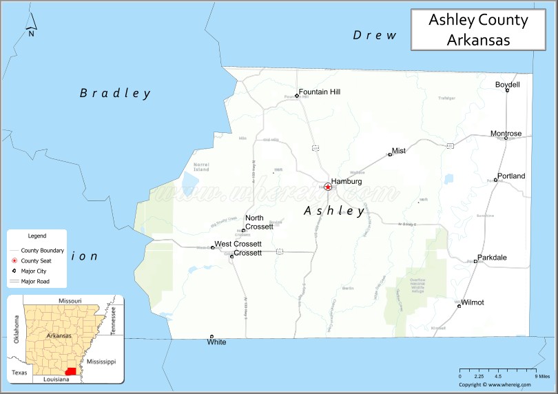
About Ashley County Map, Arkansas: The map showing the county boundary, county seat, major cities, highways, water bodies and neighbouring counties.
Related Arkansas & US Links
Map of Ashley County, Arkansas
Ashley County is a county located in the U.S. state of Arkansas. It's county seat is Hamburg. As per 2020 census, the population of Ashley County is 18674 people and population density is square miles. According to the United States Census Bureau, the county has a total area of 939.08 sq mi (2,432 km2). Ashley County was established on -18657.
Ashley County Facts
| Continent | North America |
| Country | United States |
| State | Arkansas |
| County Seat | Hamburg |
| Largest City/Town | Crossett |
| Established | 1848 |
| Total Area | 939 sq mi (2,432 sq km) |
| Land Area | 925 sq mi (2,396 sq km) |
| Water Area | 14 sq mi (36 sq km) |
| Population | 19,740 (Census 2020) |
| Population Density | 21.3 people per sq mi |
| Time Zone | Central Time Zone (CST/CDT) |
| Major Highways | US Highway 82, US Highway 425, Arkansas Highway 133 |
| Major Rivers | Ouachita River, Saline River, Bayou Bartholomew |
| Neighboring Counties | Chicot County, Drew County, Union County, Morehouse Parish (LA), West Carroll Parish (LA) |
| Famous For | Timber industry, Crossett paper mills, Bayou Bartholomew, and Delta forests |
| Top Attractions | Overflow National Wildlife Refuge, Crossett Harbor Recreation Area, Bayou Bartholomew, Hamburg historic district |
| Official Website | Official Website |
About Ashley County, Arkansas
Ashley County is located in southeastern Arkansas in the United States and was established in 1848. The county seat is Hamburg, while Crossett is the largest city. Ashley County is known for forestry, timber production, paper manufacturing, wetlands, and outdoor recreation along Bayou Bartholomew and the Ouachita River region.
Cities and Towns in Ashley County, Arkansas
| City/Town | Population (Census 2020) | Latitude & Longitude |
|---|---|---|
| Crossett | 4,919 | 33.1282°N, 91.9612°W |
| Hamburg (county seat) | 2,857 | 33.2287°N, 91.7979°W |
| North Crossett | 2,756 | 33.1721°N, 91.9796°W |
| Portland | 430 | 33.2368°N, 91.5129°W |
| Wilmot | 374 | 33.0615°N, 91.5735°W |
| Fountain Hill | 175 | 33.3385°N, 91.8440°W |
| Parkdale | 277 | 33.1204°N, 91.5465°W |
| Bayou Bartholomew region | Wetlands and forest area | 33.2000°N, 91.8000°W |
Golf Courses in Ashley County, Arkansas
| Golf Course | Location | Latitude & Longitude |
|---|---|---|
| Pine Hills Country Club | Crossett | 33.1219°N, 91.9753°W |
| Hamburg Country Club | Hamburg | 33.2311°N, 91.8004°W |
| Chemin-A-Haut Country Club | Bastrop nearby, Louisiana | 32.7794°N, 91.9097°W |
Roads and Highways in Ashley County, Arkansas
Major highways connect the county to southeastern Arkansas, Louisiana, and regional timber communities.
- US Highway 82 - east-west route connecting Crossett, Hamburg, and nearby Mississippi Delta communities
- US Highway 425 - north-south highway linking Arkansas with Louisiana and Mississippi
- Arkansas Highway 133 - regional route serving timber and rural communities
What Are the Neighboring Counties and Parishes of Ashley County
- Drew County (north)
- Chicot County (east)
- Union County (west)
- Morehouse Parish, Louisiana (southwest)
- West Carroll Parish, Louisiana (south)
Whar Are the Top Attractions in Ashley County, Arkansas
The county offers a mix of wetlands, forest recreation, and cultural heritage attractions.
- Overflow National Wildlife Refuge - wetlands habitat for birdwatching, fishing, and wildlife viewing
- Crossett Harbor Recreation Area - boating, fishing, and Ouachita River outdoor activities
- Bayou Bartholomew - scenic waterway known for canoeing and biodiversity
- Hamburg historic district - courthouse square, historic buildings, and local culture
- Felsenthal National Wildlife Refuge nearby - hunting, fishing, and nature recreation destination
- Crossett City Park and recreation facilities - community events and outdoor activities
- Timber and forestry heritage areas - exhibits and industrial history attractions
- Ouachita River recreation areas - boating, camping, and fishing opportunities
- Delta forests and scenic drives - pine forests and southern Arkansas landscapes
- Annual community festivals and fairs - local food, music, and cultural celebrations
- Bayou wetlands wildlife photography spots - bird migration and swamp scenery
- Local museums and heritage exhibits - displays on Ashley County history and timber industries
What is the Distance from Ashley County to Nearby Cities
The following distances are measured by road (driving).
- Hamburg to Crossett (Ashley County), Arkansas - 17 mi (27 km)
- Hamburg to Monticello (Drew County), Arkansas - 34 mi (55 km)
- Hamburg to Monroe (Ouachita Parish), Louisiana - 72 mi (116 km)
- Hamburg to Pine Bluff (Jefferson County), Arkansas - 103 mi (166 km)
- Hamburg to Little Rock (Pulaski County), Arkansas - 138 mi (222 km)
- Hamburg to El Dorado (Union County), Arkansas - 67 mi (108 km)
- Hamburg to Jackson (Hinds County), Mississippi - 180 mi (290 km)
- Hamburg to Shreveport (Caddo Parish), Louisiana - 153 mi (246 km)
- Hamburg to Memphis (Shelby County), Tennessee - 209 mi (336 km)
- Hamburg to Baton Rouge (East Baton Rouge Parish), Louisiana - 230 mi (370 km)
- Hamburg to Dallas (Dallas County), Texas - 323 mi (520 km)
- Hamburg to New Orleans (Orleans Parish), Louisiana - 333 mi (536 km)
FAQs about Ashley County
Ashley County is located in southeastern Arkansas near the Louisiana border in the United States.
The population of Ashley County was 19,740 according to the Census 2020.
Ashley County is known for timber production, paper mills, Bayou Bartholomew, and forest recreation.
The county is served by US Highway 82, US Highway 425, and Arkansas Highway 133.
Popular attractions include Overflow National Wildlife Refuge, Crossett Harbor Recreation Area, Bayou Bartholomew, and Hamburg historic district.
References
- QuickFacts - U.S. Census Bureau
- United States Census Bureau
- United States Geological Survey (USGS)
- National Geodetic Survey
- Official Website
- Arkansas County Map
- Ashley County Map
- Baxter County Map
- Benton County Map
- Boone County Map
- Bradley County Map
- Calhoun County Map
- Carroll County Map
- Chicot County Map
- Clark County Map
- Clay County Map
- Cleburne County Map
- Cleveland County Map
- Columbia County Map
- Conway County Map
- Craighead County Map
- Crawford County Map
- Crittenden County Map
- Cross County Map
- Dallas County Map
- Desha County Map
- Drew County Map
- Faulkner County Map
- Franklin County Map
- Fulton County Map
- Garland County Map
- Grant County Map
- Greene County Map
- Hempstead County Map
- Hot Spring County Map
- Howard County Map
- Independence County Map
- Izard County Map
- Jackson County Map
- Jefferson County Map
- Johnson County Map
- Lafayette County Map
- Lawrence County Map
- Lee County Map
- Lincoln County Map
- Little River County Map
- Logan County Map
- Lonoke County Map
- Madison County Map
- Marion County Map
- Miller County Map
- Mississippi County Map
- Monroe County Map
- Montgomery County Map
- Nevada County Map
- Newton County Map
- Ouachita County Map
- Perry County Map
- Phillips County Map
- Pike County Map
- Poinsett County Map
- Polk County Map
- Pope County Map
- Prairie County Map
- Pulaski County Map
- Randolph County Map
- St Francis County Map
- Saline County Map
- Scott County Map
- Searcy County Map
- Sebastian County Map
- Sevier County Map
- Sharp County Map
- Stone County Map
- Union County Map
- Van Buren County Map
- Washington County Map
- White County Map
- Woodruff County Map
- Yell County Map
- Alabama Counties
- Alaska boroughs
- Arizona Counties
- Arkansas Counties
- California County Map
- Colorado Counties
- Connecticut Counties
- Delaware Counties
- Florida County Map
- Georgia County Map
- Hawaii Counties
- Idaho Counties
- Illinois Counties
- Indiana Counties
- Iowa Counties
- Kansas Counties
- Kentucky Counties
- Louisiana Counties
- Maine Counties
- Maryland Counties
- Massachusetts Counties
- Michigan County Map
- Minnesota Counties
- Mississippi Counties
- Missouri Counties
- Montana Counties
- Nebraska Counties
- Nevada Counties
- New York Counties
- New Hampshire Counties
- New Jersey Counties
- New Mexico Counties
- North Carolina Counties
- North Dakota Counties
- Ohio County Map
- Oklahoma Counties
- Oregon Counties
- Pennsylvania Counties
- Rhode Island Counties
- South Carolina Counties
- South Dakota Counties
- Map of Tennessee
- Texas County Map
- Utah Counties
- Vermont Counties
- Virginia Counties
- Washington Counties
- West Virginia Counties
- Wisconsin Counties
- Wyoming Counties