Written and Fact-checked by Whereig Editors, Reviewed by Mukesh Kumar| Last Updated On: May 10, 2026
Map of Poinsett County - Poinsett County is a county located in the U.S. state of Arkansas. Poinsett County Map showing cities, highways, important places and water bodies. Get Where is Poinsett County located in the map, major cities in Poinsett county, population, areas, and places of interest.
Poinsett County Map, Arkansas
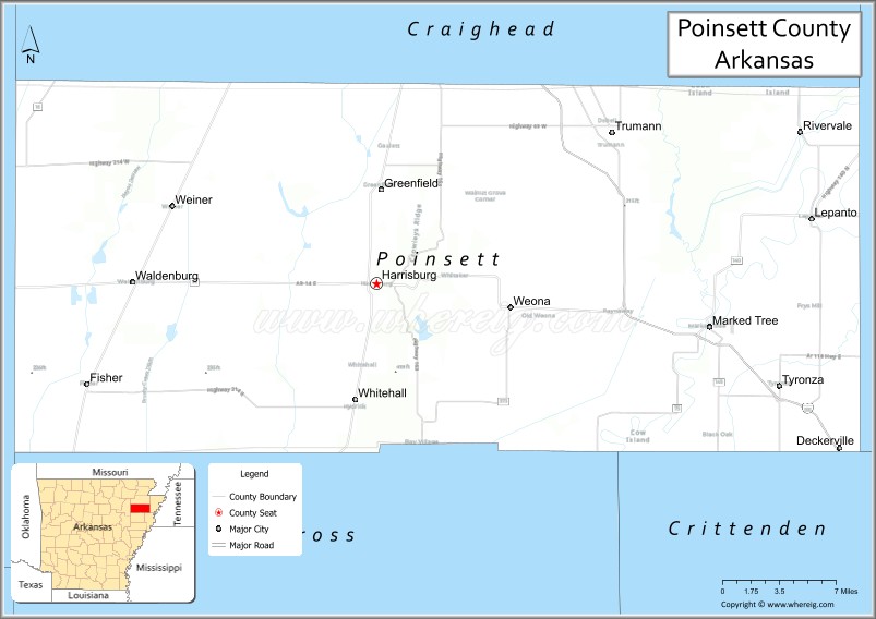
About Poinsett County Map, Arkansas: The map showing the county boundary, county seat, major cities, highways, water bodies and neighbouring counties.
Related Arkansas & US Links
Map of Poinsett County, Arkansas
Poinsett County is a county located in the U.S. state of Arkansas. It's county seat is Harrisburg. As per 2020 census, the population of Poinsett County is 22660 people and population density is square miles. According to the United States Census Bureau, the county has a total area of 763.39 sq mi (1,977 km2). Poinsett County was established on -22585.
Poinsett County Facts
| Continent | North America |
| Country | United States |
| State | Arkansas |
| County Seat | Harrisburg |
| Largest City/Town | Trumann |
| Established | February 28, 1838 |
| Total Area | 764 sq mi (1,979 sq km) |
| Land Area | 758 sq mi (1,963 sq km) |
| Water Area | 6 sq mi (16 sq km) |
| Population | 22,743 (Census 2020) |
| Population Density | 30.0 people per sq mi |
| Time Zone | Central Time Zone (CT) |
| Major Highways | Interstate 555, US 49, US 63, AR 1, AR 14, AR 69 |
| Major Rivers | St. Francis River, Tyronza River |
| Neighboring Counties | Craighead County, Cross County, Crittenden County, Jackson County, Mississippi County |
| Famous For | Agriculture, Arkansas Delta farmland, rice production, Bay Village Historic District |
| Top Attractions | Lake Poinsett State Park area, Bay Village Historic District, Crowley's Ridge Parkway, St. Francis River |
| Official Website | Official Website |
About Poinsett County, Arkansas
Poinsett County is located in northeastern Arkansas in the United States and was established in 1838. The county seat is Harrisburg, while Trumann is the largest city in the county. The county lies within the Arkansas Delta region and is known for its fertile farmland, agricultural economy, wetlands, and small historic communities.
Cities and Towns in Poinsett County, Arkansas
| City/Town | Population (Census 2020) | Latitude & Longitude |
|---|---|---|
| Harrisburg (county seat) | 2,212 | 35.5640°N, 90.7168°W |
| Trumann | 6,114 | 35.6731°N, 90.5073°W |
| Lepanto | 1,732 | 35.6117°N, 90.3337°W |
| Marked Tree | 2,286 | 35.5329°N, 90.4190°W |
| Tyronza | 716 | 35.4870°N, 90.3593°W |
| Weiner | 647 | 35.6206°N, 90.9001°W |
| Fisher | 223 | 35.4901°N, 90.9693°W |
| Rivervale | 89 | 35.6765°N, 90.3382°W |
| Waldenburg | 61 | 35.5659°N, 90.9371°W |
Golf Courses in Poinsett County, Arkansas
| Golf Course | Location | Latitude & Longitude |
|---|---|---|
| Trumann Country Club | Trumann | 35.6759°N, 90.5226°W |
| Marked Tree Golf Course | Marked Tree | 35.5367°N, 90.4292°W |
Roads and Highways in Poinsett County, Arkansas
Major highways connect the county to nearby Delta cities and agricultural communities.
- Interstate 555 - major highway connecting the county with Jonesboro and Interstate 55
- US Highway 49 - north-south route through the eastern Arkansas Delta region
- US Highway 63 - important regional route connecting northeast Arkansas communities
- Arkansas Highway 1 - state highway serving agricultural and rural areas
- Arkansas Highway 14 - east-west roadway connecting local towns and farming regions
- Arkansas Highway 69 - local route linking smaller communities across the county
What Are the Neighboring Counties of Poinsett County
- Craighead County (north)
- Mississippi County (east)
- Crittenden County (southeast)
- Cross County (south)
- Jackson County (west)
Whar Are the Top Attractions in Poinsett County, Arkansas
The county offers a mix of natural and cultural attractions.
- Lake Poinsett Recreation Area - popular fishing, boating, and camping destination
- Bay Village Historic District - preserved 19th-century village and Arkansas historic site
- Crowley's Ridge Parkway - scenic roadway passing through forested ridge landscapes
- St. Francis River - river destination for fishing, boating, and wildlife viewing
- Marked Tree Historic Downtown - small historic district with local heritage sites
- Tyronza River Area - natural wetland and outdoor recreation area
- Southern Tenant Farmers Museum nearby - museum highlighting Delta farming history
- Harrisburg City Park - public recreation area with sports and picnic facilities
- Weiner Community Area - rural farming community with Delta scenery
- Lepanto Museum and Heritage Area - local history exhibits and cultural displays
- Lake Hogue nearby - scenic lake known for fishing and birdwatching
- Arkansas Delta Farmland Scenic Drives - countryside routes showcasing Delta agriculture
What is the Distance from Poinsett County to Nearby Cities
The following distances are measured by road (driving).
- Harrisburg to Jonesboro (Craighead County), Arkansas - 24 mi (39 km)
- Harrisburg to West Memphis (Crittenden County), Arkansas - 66 mi (106 km)
- Harrisburg to Blytheville (Mississippi County), Arkansas - 53 mi (85 km)
- Harrisburg to Newport (Jackson County), Arkansas - 45 mi (72 km)
- Harrisburg to Memphis (Shelby County), Tennessee - 73 mi (117 km)
- Harrisburg to Paragould (Greene County), Arkansas - 41 mi (66 km)
- Harrisburg to Batesville (Independence County), Arkansas - 77 mi (124 km)
- Harrisburg to Forrest City (St. Francis County), Arkansas - 54 mi (87 km)
- Harrisburg to Little Rock (Pulaski County), Arkansas - 121 mi (195 km)
- Harrisburg to Searcy (White County), Arkansas - 86 mi (138 km)
- Harrisburg to Trumann (Poinsett County), Arkansas - 18 mi (29 km)
- Harrisburg to Walnut Ridge (Lawrence County), Arkansas - 53 mi (85 km)
FAQs about Poinsett County
Poinsett County is located in northeastern Arkansas within the Arkansas Delta region.
Poinsett County had a population of 22,743 according to the 2020 United States Census.
Poinsett County is known for agriculture, rice farming, Delta landscapes, and historic communities.
The major highways include Interstate 555, US Highway 49, US Highway 63, Arkansas Highway 1, Arkansas Highway 14, and Arkansas Highway 69.
Yes, Poinsett County has golf facilities including Trumann Country Club and local recreational golf courses.
References
- QuickFacts - U.S. Census Bureau
- United States Census Bureau
- United States Geological Survey (USGS)
- National Geodetic Survey
- Official County Website
- Arkansas County Map
- Ashley County Map
- Baxter County Map
- Benton County Map
- Boone County Map
- Bradley County Map
- Calhoun County Map
- Carroll County Map
- Chicot County Map
- Clark County Map
- Clay County Map
- Cleburne County Map
- Cleveland County Map
- Columbia County Map
- Conway County Map
- Craighead County Map
- Crawford County Map
- Crittenden County Map
- Cross County Map
- Dallas County Map
- Desha County Map
- Drew County Map
- Faulkner County Map
- Franklin County Map
- Fulton County Map
- Garland County Map
- Grant County Map
- Greene County Map
- Hempstead County Map
- Hot Spring County Map
- Howard County Map
- Independence County Map
- Izard County Map
- Jackson County Map
- Jefferson County Map
- Johnson County Map
- Lafayette County Map
- Lawrence County Map
- Lee County Map
- Lincoln County Map
- Little River County Map
- Logan County Map
- Lonoke County Map
- Madison County Map
- Marion County Map
- Miller County Map
- Mississippi County Map
- Monroe County Map
- Montgomery County Map
- Nevada County Map
- Newton County Map
- Ouachita County Map
- Perry County Map
- Phillips County Map
- Pike County Map
- Poinsett County Map
- Polk County Map
- Pope County Map
- Prairie County Map
- Pulaski County Map
- Randolph County Map
- St Francis County Map
- Saline County Map
- Scott County Map
- Searcy County Map
- Sebastian County Map
- Sevier County Map
- Sharp County Map
- Stone County Map
- Union County Map
- Van Buren County Map
- Washington County Map
- White County Map
- Woodruff County Map
- Yell County Map
- Alabama Counties
- Alaska boroughs
- Arizona Counties
- Arkansas Counties
- California County Map
- Colorado Counties
- Connecticut Counties
- Delaware Counties
- Florida County Map
- Georgia County Map
- Hawaii Counties
- Idaho Counties
- Illinois Counties
- Indiana Counties
- Iowa Counties
- Kansas Counties
- Kentucky Counties
- Louisiana Counties
- Maine Counties
- Maryland Counties
- Massachusetts Counties
- Michigan County Map
- Minnesota Counties
- Mississippi Counties
- Missouri Counties
- Montana Counties
- Nebraska Counties
- Nevada Counties
- New York Counties
- New Hampshire Counties
- New Jersey Counties
- New Mexico Counties
- North Carolina Counties
- North Dakota Counties
- Ohio County Map
- Oklahoma Counties
- Oregon Counties
- Pennsylvania Counties
- Rhode Island Counties
- South Carolina Counties
- South Dakota Counties
- Map of Tennessee
- Texas County Map
- Utah Counties
- Vermont Counties
- Virginia Counties
- Washington Counties
- West Virginia Counties
- Wisconsin Counties
- Wyoming Counties