Written and Fact-checked by Whereig Editors, Reviewed by Mukesh Kumar| Last Updated On: May 10, 2026
Map of Lonoke County - Lonoke County is a county located in the U.S. state of Arkansas. Lonoke County Map showing cities, highways, important places and water bodies. Get Where is Lonoke County located in the map, major cities in Lonoke county, population, areas, and places of interest.
Lonoke County Map, Arkansas
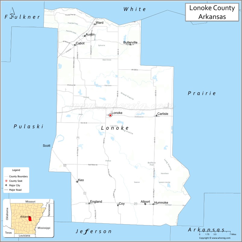
About Lonoke County Map, Arkansas: The map showing the county boundary, county seat, major cities, highways, water bodies and neighbouring counties.
Related Arkansas & US Links
Map of Lonoke County, Arkansas
Lonoke County is a county located in the U.S. state of Arkansas. It's county seat is Lonoke. As per 2020 census, the population of Lonoke County is 74722 people and population density is square miles. According to the United States Census Bureau, the county has a total area of 802.43 sq mi (2,078 km2). Lonoke County was established on -9754.
Lonoke County Facts
| Continent | North America |
| Country | United States |
| State | Arkansas |
| County Seat | Lonoke |
| Largest City/Town | Cabot |
| Established | 1873 |
| Total Area | 802 sq mi (2,077 sq km) |
| Land Area | 771 sq mi (1,997 sq km) |
| Water Area | 31 sq mi (80 sq km) |
| Population | 74,015 (Census 2020) |
| Population Density | 96.0 people per sq mi |
| Time Zone | Central Time Zone (CST/CDT) |
| Major Highways | Interstate 40, US Highway 67/167, Arkansas Highway 5 |
| Major Rivers | Arkansas River, Bayou Meto |
| Neighboring Counties | Faulkner County, Jefferson County, Prairie County, Pulaski County, White County |
| Famous For | Cabot, agriculture, suburban growth near Little Rock, and duck hunting |
| Top Attractions | Camp Nelson Confederate Cemetery, Cabot Aquatic Park, Bayou Meto Wildlife Management Area, downtown Lonoke |
| Official Website | Official Website |
About Lonoke County, Arkansas
Lonoke County is located in central Arkansas in the United States and was established in 1873. The county seat is Lonoke, while Cabot is the largest city. Lonoke County is known for its agricultural economy, rapid suburban development near Little Rock, waterfowl hunting traditions, and family-oriented communities.
Cities and Towns in Lonoke County, Arkansas
| City/Town | Population (Census 2020) | Latitude & Longitude |
|---|---|---|
| Cabot | 26,569 | 34.9745°N, 92.0165°W |
| Lonoke (county seat) | 4,276 | 34.7837°N, 91.8996°W |
| Jacksonville (partly) | 28,364 | 34.8668°N, 92.1104°W |
| Austin | 3,038 | 35.0020°N, 91.9832°W |
| England | 2,825 | 34.5448°N, 91.9690°W |
| Ward | 6,052 | 35.0312°N, 91.9504°W |
| Bayou Meto region | Wetland recreation area | 34.7000°N, 91.9000°W |
| Central Arkansas prairie region | Agricultural landscape area | 34.8500°N, 91.9800°W |
Golf Courses in Lonoke County, Arkansas
| Golf Course | Location | Latitude & Longitude |
|---|---|---|
| Greystone Country Club | Cabot | 34.9897°N, 92.0240°W |
| Cabot Mini Golf & Entertainment | Cabot | 34.9785°N, 92.0148°W |
| Rebsamen Golf Course | Little Rock nearby | 34.7691°N, 92.3198°W |
Roads and Highways in Lonoke County, Arkansas
Major highways connect the county to Little Rock, northeast Arkansas, and surrounding suburban communities.
- Interstate 40 - major interstate linking the county with Little Rock and Memphis
- US Highway 67/167 - important north-south transportation corridor through Cabot
- Arkansas Highway 5 - regional route serving suburban and rural communities
What Are the Neighboring Counties of Lonoke County
- Faulkner County (northwest)
- Jefferson County (south)
- Prairie County (east)
- Pulaski County (west)
- White County (north)
Whar Are the Top Attractions in Lonoke County, Arkansas
The county offers a mix of suburban recreation, historical sites, and outdoor attractions.
- Camp Nelson Confederate Cemetery - historic Civil War landmark and memorial site
- Cabot Aquatic Park - family recreation and water attractions
- Bayou Meto Wildlife Management Area - duck hunting, birdwatching, and wetlands recreation
- Historic downtown Lonoke - local shops, restaurants, and community events
- Greystone Country Club - golf and recreational activities
- Central Arkansas scenic countryside drives - farmland and prairie landscapes
- Fishing and boating opportunities along regional waterways - outdoor recreation destinations
- Community festivals and county fairs - celebrations of Arkansas traditions and agriculture
- Nature trails and wildlife observation sites - wetland and prairie habitats
- Historic churches and courthouse district - local history and architecture
- Nearby Little Rock attractions access - museums, entertainment, and shopping opportunities
- Regional parks and sports complexes - family-friendly recreation and events
What is the Distance from Lonoke County to Nearby Cities
The following distances are measured by road (driving).
- Lonoke to Little Rock (Pulaski County), Arkansas - 29 mi (47 km)
- Lonoke to Conway (Faulkner County), Arkansas - 46 mi (74 km)
- Lonoke to Searcy (White County), Arkansas - 42 mi (68 km)
- Lonoke to Pine Bluff (Jefferson County), Arkansas - 56 mi (90 km)
- Lonoke to Memphis (Shelby County), Tennessee - 128 mi (206 km)
- Lonoke to Hot Springs (Garland County), Arkansas - 79 mi (127 km)
- Lonoke to Jonesboro (Craighead County), Arkansas - 115 mi (185 km)
- Lonoke to Tulsa (Tulsa County), Oklahoma - 277 mi (446 km)
- Lonoke to Dallas (Dallas County), Texas - 324 mi (521 km)
- Lonoke to Nashville (Davidson County), Tennessee - 338 mi (544 km)
- Lonoke to St. Louis (St. Louis City), Missouri - 356 mi (573 km)
- Lonoke to Kansas City (Jackson County), Missouri - 418 mi (673 km)
FAQs about Lonoke County
Lonoke County is located in central Arkansas in the United States.
The population of Lonoke County was 74,015 according to the Census 2020.
Lonoke County is known for Cabot, agriculture, suburban growth near Little Rock, and duck hunting traditions.
The county is served by Interstate 40, US Highway 67/167, and Arkansas Highway 5.
Popular attractions include Camp Nelson Confederate Cemetery, Cabot Aquatic Park, Bayou Meto Wildlife Management Area, and historic downtown Lonoke.
References
- QuickFacts - U.S. Census Bureau
- United States Census Bureau
- United States Geological Survey (USGS)
- National Geodetic Survey
- Official Website
- Arkansas County Map
- Ashley County Map
- Baxter County Map
- Benton County Map
- Boone County Map
- Bradley County Map
- Calhoun County Map
- Carroll County Map
- Chicot County Map
- Clark County Map
- Clay County Map
- Cleburne County Map
- Cleveland County Map
- Columbia County Map
- Conway County Map
- Craighead County Map
- Crawford County Map
- Crittenden County Map
- Cross County Map
- Dallas County Map
- Desha County Map
- Drew County Map
- Faulkner County Map
- Franklin County Map
- Fulton County Map
- Garland County Map
- Grant County Map
- Greene County Map
- Hempstead County Map
- Hot Spring County Map
- Howard County Map
- Independence County Map
- Izard County Map
- Jackson County Map
- Jefferson County Map
- Johnson County Map
- Lafayette County Map
- Lawrence County Map
- Lee County Map
- Lincoln County Map
- Little River County Map
- Logan County Map
- Lonoke County Map
- Madison County Map
- Marion County Map
- Miller County Map
- Mississippi County Map
- Monroe County Map
- Montgomery County Map
- Nevada County Map
- Newton County Map
- Ouachita County Map
- Perry County Map
- Phillips County Map
- Pike County Map
- Poinsett County Map
- Polk County Map
- Pope County Map
- Prairie County Map
- Pulaski County Map
- Randolph County Map
- St Francis County Map
- Saline County Map
- Scott County Map
- Searcy County Map
- Sebastian County Map
- Sevier County Map
- Sharp County Map
- Stone County Map
- Union County Map
- Van Buren County Map
- Washington County Map
- White County Map
- Woodruff County Map
- Yell County Map
- Alabama Counties
- Alaska boroughs
- Arizona Counties
- Arkansas Counties
- California County Map
- Colorado Counties
- Connecticut Counties
- Delaware Counties
- Florida County Map
- Georgia County Map
- Hawaii Counties
- Idaho Counties
- Illinois Counties
- Indiana Counties
- Iowa Counties
- Kansas Counties
- Kentucky Counties
- Louisiana Counties
- Maine Counties
- Maryland Counties
- Massachusetts Counties
- Michigan County Map
- Minnesota Counties
- Mississippi Counties
- Missouri Counties
- Montana Counties
- Nebraska Counties
- Nevada Counties
- New York Counties
- New Hampshire Counties
- New Jersey Counties
- New Mexico Counties
- North Carolina Counties
- North Dakota Counties
- Ohio County Map
- Oklahoma Counties
- Oregon Counties
- Pennsylvania Counties
- Rhode Island Counties
- South Carolina Counties
- South Dakota Counties
- Map of Tennessee
- Texas County Map
- Utah Counties
- Vermont Counties
- Virginia Counties
- Washington Counties
- West Virginia Counties
- Wisconsin Counties
- Wyoming Counties