Written and Fact-checked by Whereig Editors, Reviewed by Mukesh Kumar| Last Updated On: May 10, 2026
Map of Phillips County - Phillips County is a county located in the U.S. state of Arkansas. Phillips County Map showing cities, highways, important places and water bodies. Get Where is Phillips County located in the map, major cities in Phillips county, population, areas, and places of interest.
Phillips County Map, Arkansas
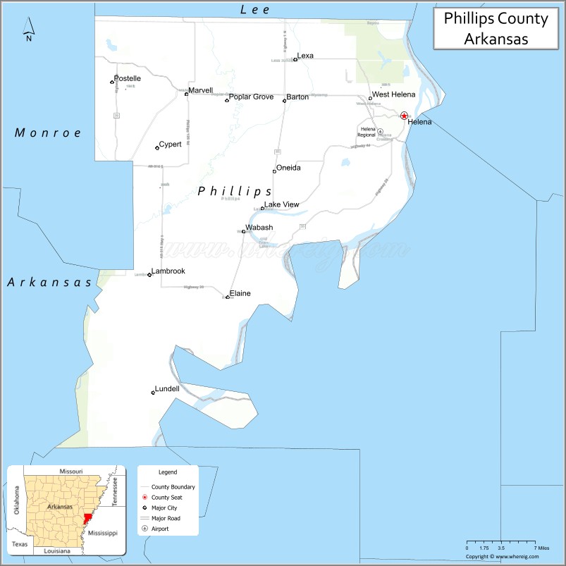
About Phillips County Map, Arkansas: The map showing the county boundary, county seat, major cities, highways, water bodies and neighbouring counties.
Related Arkansas & US Links
Map of Phillips County, Arkansas
Phillips County is a county located in the U.S. state of Arkansas. It's county seat is Helena. As per 2020 census, the population of Phillips County is 15906 people and population density is square miles. According to the United States Census Bureau, the county has a total area of 727.29 sq mi (1,884 km2). Phillips County was established on -29097.
Phillips County Facts
| Continent | North America |
| Country | United States |
| State | Arkansas |
| County Seat | Helena-West Helena |
| Largest City/Town | Helena-West Helena |
| Established | May 1, 1820 |
| Total Area | 727 sq mi (1,883 sq km) |
| Land Area | 696 sq mi (1,803 sq km) |
| Water Area | 31 sq mi (80 sq km) |
| Population | 16,568 (Census 2020) |
| Population Density | 23.8 people per sq mi |
| Time Zone | Central Time Zone (CT) |
| Major Highways | US 49, US 49B, US 79, AR 1, AR 20, AR 44 |
| Major Rivers | Mississippi River, St. Francis River |
| Neighboring Counties | Lee County, Monroe County, Desha County, Coahoma County (MS), Tunica County (MS) |
| Famous For | Delta blues music, Mississippi River, agriculture, Civil War history |
| Top Attractions | Delta Cultural Center, Helena River Park, Mississippi River, King Biscuit Blues Festival |
| Official Website | Official Website |
About Phillips County, Arkansas
Phillips County is located in the eastern part of Arkansas in the United States and was established in 1820. The county seat is Helena-West Helena, which is also the largest city in the county. The county lies within the Arkansas Delta region along the Mississippi River and is known for its rich musical heritage, agricultural lands, and historical importance in the Mississippi River Valley.
Cities and Towns in Phillips County, Arkansas
| City/Town | Population (Census 2020) | Latitude & Longitude |
|---|---|---|
| Helena-West Helena (county seat) | 9,519 | 34.5298°N, 90.5918°W |
| Elaine | 513 | 34.3065°N, 90.8529°W |
| Lake View | 327 | 34.4148°N, 90.7670°W |
| Lexa | 286 | 34.6051°N, 90.7509°W |
| Marvell | 855 | 34.5551°N, 90.9123°W |
| Poplar Grove | 143 | 34.5567°N, 90.8526°W |
| West Helena | part of Helena-West Helena | 34.5504°N, 90.6418°W |
| Barton (CDP) | 308 | 34.4792°N, 90.7651°W |
| Oneida (CDP) | 77 | 34.4218°N, 90.8301°W |
Golf Courses in Phillips County, Arkansas
| Golf Course | Location | Latitude & Longitude |
|---|---|---|
| Foxglove Golf Course | Helena-West Helena | 34.5456°N, 90.6129°W |
| Delta View Golf Club | Marvell | 34.5532°N, 90.9185°W |
Roads and Highways in Phillips County, Arkansas
Major highways connect the county to nearby Delta cities and Mississippi River communities.
- US Highway 49 - major north-south highway connecting Helena-West Helena with Mississippi and central Arkansas
- US Highway 49B - local route serving communities within the Delta region
- US Highway 79 - regional highway connecting the county with eastern Arkansas cities
- Arkansas Highway 1 - important state route through agricultural communities
- Arkansas Highway 20 - east-west highway connecting towns near the Mississippi River
- Arkansas Highway 44 - scenic Delta roadway serving rural communities and farmland
What Are the Neighboring Counties of Phillips County
- Lee County (west)
- Monroe County (northwest)
- Desha County (south)
- Coahoma County, Mississippi (east)
- Tunica County, Mississippi (northeast)
Whar Are the Top Attractions in Phillips County, Arkansas
The county offers a mix of natural and cultural attractions.
- Delta Cultural Center - museum and cultural center focused on Delta music and history
- Helena River Park - scenic riverfront park along the Mississippi River
- King Biscuit Blues Festival - famous annual blues music festival attracting visitors from around the world
- Mississippi River Levee - popular scenic area for walking, photography, and river views
- Pillow-Thompson House - historic Victorian home in Helena-West Helena
- Fort Curtis Historic Site - reconstructed Civil War fort connected to the Battle of Helena
- Freedom Park - riverside park commemorating Delta history and culture
- Battery C Park - Civil War battlefield and memorial area
- Helena Museum of Phillips County - museum featuring regional history and artifacts
- Delta Heritage Trail State Park nearby - recreational trail popular for biking and walking
- Elaine Legacy Center - site connected to the history of the Elaine Massacre and civil rights history
- Mississippi River State Scenic Area - river landscapes with wildlife viewing and fishing opportunities
What is the Distance from Phillips County to Nearby Cities
The following distances are measured by road (driving).
- Helena-West Helena to Memphis (Shelby County), Tennessee - 70 mi (113 km)
- Helena-West Helena to Jonesboro (Craighead County), Arkansas - 114 mi (183 km)
- Helena-West Helena to Pine Bluff (Jefferson County), Arkansas - 97 mi (156 km)
- Helena-West Helena to Little Rock (Pulaski County), Arkansas - 119 mi (191 km)
- Helena-West Helena to Clarksdale (Coahoma County), Mississippi - 31 mi (50 km)
- Helena-West Helena to Tunica (Tunica County), Mississippi - 54 mi (87 km)
- Helena-West Helena to Forrest City (St. Francis County), Arkansas - 52 mi (84 km)
- Helena-West Helena to Greenville (Washington County), Mississippi - 89 mi (143 km)
- Helena-West Helena to Brinkley (Monroe County), Arkansas - 70 mi (113 km)
- Helena-West Helena to West Memphis (Crittenden County), Arkansas - 73 mi (117 km)
- Helena-West Helena to Batesville (Independence County), Arkansas - 122 mi (196 km)
- Helena-West Helena to Vicksburg (Warren County), Mississippi - 158 mi (254 km)
FAQs about Phillips County
Phillips County is located in eastern Arkansas along the Mississippi River in the Arkansas Delta region.
Phillips County had a population of 16,568 according to the 2020 United States Census.
Phillips County is known for Delta blues music, Mississippi River history, agriculture, and the King Biscuit Blues Festival.
The major highways include US Highway 49, US Highway 49B, US Highway 79, Arkansas Highway 1, Arkansas Highway 20, and Arkansas Highway 44.
Yes, Phillips County has golf facilities including Foxglove Golf Course and local recreational golf areas.
References
- QuickFacts - U.S. Census Bureau
- United States Census Bureau
- United States Geological Survey (USGS)
- National Geodetic Survey
- Official County Website
- Arkansas County Map
- Ashley County Map
- Baxter County Map
- Benton County Map
- Boone County Map
- Bradley County Map
- Calhoun County Map
- Carroll County Map
- Chicot County Map
- Clark County Map
- Clay County Map
- Cleburne County Map
- Cleveland County Map
- Columbia County Map
- Conway County Map
- Craighead County Map
- Crawford County Map
- Crittenden County Map
- Cross County Map
- Dallas County Map
- Desha County Map
- Drew County Map
- Faulkner County Map
- Franklin County Map
- Fulton County Map
- Garland County Map
- Grant County Map
- Greene County Map
- Hempstead County Map
- Hot Spring County Map
- Howard County Map
- Independence County Map
- Izard County Map
- Jackson County Map
- Jefferson County Map
- Johnson County Map
- Lafayette County Map
- Lawrence County Map
- Lee County Map
- Lincoln County Map
- Little River County Map
- Logan County Map
- Lonoke County Map
- Madison County Map
- Marion County Map
- Miller County Map
- Mississippi County Map
- Monroe County Map
- Montgomery County Map
- Nevada County Map
- Newton County Map
- Ouachita County Map
- Perry County Map
- Phillips County Map
- Pike County Map
- Poinsett County Map
- Polk County Map
- Pope County Map
- Prairie County Map
- Pulaski County Map
- Randolph County Map
- St Francis County Map
- Saline County Map
- Scott County Map
- Searcy County Map
- Sebastian County Map
- Sevier County Map
- Sharp County Map
- Stone County Map
- Union County Map
- Van Buren County Map
- Washington County Map
- White County Map
- Woodruff County Map
- Yell County Map
- Alabama Counties
- Alaska boroughs
- Arizona Counties
- Arkansas Counties
- California County Map
- Colorado Counties
- Connecticut Counties
- Delaware Counties
- Florida County Map
- Georgia County Map
- Hawaii Counties
- Idaho Counties
- Illinois Counties
- Indiana Counties
- Iowa Counties
- Kansas Counties
- Kentucky Counties
- Louisiana Counties
- Maine Counties
- Maryland Counties
- Massachusetts Counties
- Michigan County Map
- Minnesota Counties
- Mississippi Counties
- Missouri Counties
- Montana Counties
- Nebraska Counties
- Nevada Counties
- New York Counties
- New Hampshire Counties
- New Jersey Counties
- New Mexico Counties
- North Carolina Counties
- North Dakota Counties
- Ohio County Map
- Oklahoma Counties
- Oregon Counties
- Pennsylvania Counties
- Rhode Island Counties
- South Carolina Counties
- South Dakota Counties
- Map of Tennessee
- Texas County Map
- Utah Counties
- Vermont Counties
- Virginia Counties
- Washington Counties
- West Virginia Counties
- Wisconsin Counties
- Wyoming Counties