Written and Fact-checked by Whereig Editors, Reviewed by Mukesh Kumar| Last Updated On: May 10, 2026
Map of St. Francis County - St. Francis County is a county located in the U.S. state of Arkansas. St. Francis County Map showing cities, highways, important places and water bodies. Get Where is St. Francis County located in the map, major cities in St. Francis county, population, areas, and places of interest.
St Francis County Map, Arkansas
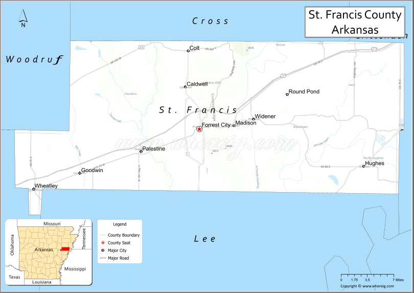
About St. Francis County Map, Arkansas: The map showing the county boundary, county seat, major cities, highways, water bodies and neighbouring counties.
Related Arkansas & US Links
Map of St Francis County, Arkansas
Sevier County is a county located in the U.S. state of Arkansas. It`s county seat is De Queen. As per 2020 census, the population of Sevier County was 15783 and population density of Sevier was square miles. According to the United States Census Bureau, the county has a total area of 581.35 sq mi (1,506 km2). Sevier County was established on -26006.
St. Francis County Facts
| Continent | North America |
| Country | United States |
| State | Arkansas |
| County Seat | Forrest City |
| Largest City/Town | Forrest City |
| Established | October 13, 1827 |
| Total Area | 643 sq mi (1,665 sq km) |
| Land Area | 635 sq mi (1,645 sq km) |
| Water Area | 8 sq mi (20 sq km) |
| Population | 23,090 (Census 2020) |
| Population Density | 36.4 people per sq mi |
| Time Zone | Central Time Zone (CT) |
| Major Highways | Interstate 40, US 70, US 79, AR 1, AR 50 |
| Major Rivers | St. Francis River, L'Anguille River |
| Neighboring Counties | Cross County, Lee County, Monroe County, Woodruff County, Crittenden County |
| Famous For | Forrest City, Delta agriculture, Crowley’s Ridge, blues heritage |
| Top Attractions | Village Creek State Park, St. Francis National Forest nearby, Forrest City Civic Center, Delta farmlands |
| Official Website | Official Website |
About St. Francis County, Arkansas
St. Francis County is located in eastern Arkansas in the United States and was established in 1827. The county seat is Forrest City, which is also the largest city in the county. The county lies within the Arkansas Delta region and is known for agriculture, Crowley’s Ridge landscapes, blues culture, and transportation connections along Interstate 40.
Cities and Towns in St. Francis County, Arkansas
| City/Town | Population (Census 2020) | Latitude & Longitude |
|---|---|---|
| Forrest City (county seat) | 12,972 | 35.0081°N, 90.7898°W |
| Colt | 378 | 35.1315°N, 90.8115°W |
| Hughes | 1,056 | 34.9493°N, 90.4704°W |
| Madison | 689 | 35.0126°N, 90.7220°W |
| Palestine | 681 | 34.9723°N, 90.8979°W |
| Widener | 273 | 35.0190°N, 90.6834°W |
| Caldwell | 452 | 35.0737°N, 90.8173°W |
| Wheatley (partial) | 355 | 34.9109°N, 91.1062°W |
| Goodwin (CDP) | 142 | 35.0812°N, 90.7741°W |
Golf Courses in St. Francis County, Arkansas
| Golf Course | Location | Latitude & Longitude |
|---|---|---|
| Forrest City Country Club | Forrest City | 35.0207°N, 90.7981°W |
| Village Creek Golf Area | Wynne nearby | 35.0904°N, 90.7947°W |
Roads and Highways in St. Francis County, Arkansas
Major highways connect the county to Memphis and central Arkansas communities.
- Interstate 40 - major east-west interstate linking Forrest City with Little Rock and Memphis
- US Highway 70 - historic transportation route through the Arkansas Delta
- US Highway 79 - regional route connecting eastern Arkansas communities
- Arkansas Highway 1 - north-south route serving agricultural towns and rural communities
- Arkansas Highway 50 - local roadway connecting smaller towns and recreation areas
What Are the Neighboring Counties of St. Francis County
- Cross County (north)
- Crittenden County (east)
- Lee County (south)
- Monroe County (southwest)
- Woodruff County (west)
Whar Are the Top Attractions in St. Francis County, Arkansas
The county offers a mix of natural and cultural attractions.
- Village Creek State Park - scenic state park with lakes, hiking trails, camping, and golf
- Forrest City Civic Center - event venue hosting concerts, conferences, and community gatherings
- Crowley’s Ridge Scenic Area - elevated ridge landscape offering unique scenery in the Delta region
- St. Francis National Forest nearby - forest recreation area with hiking and wildlife viewing
- Forrest City Downtown Historic District - historic district with shops and local restaurants
- Delta farmlands - expansive agricultural landscapes known for cotton and soybean production
- St. Francis River Recreation Areas - outdoor destinations for fishing and boating
- East Arkansas Community College - educational institution serving the region
- Madison Historic Community Area - small town with Delta heritage and local culture
- Village Creek Lakes - popular fishing and boating destinations within the state park
- Arkansas Welcome Center at Forrest City - visitor information and regional exhibits
- Delta Blues Heritage Sites nearby - cultural attractions celebrating eastern Arkansas music history
What is the Distance from St. Francis County to Nearby Cities
The following distances are measured by road (driving).
- Forrest City to Memphis (Shelby County), Tennessee - 46 mi (74 km)
- Forrest City to Little Rock (Pulaski County), Arkansas - 87 mi (140 km)
- Forrest City to Jonesboro (Craighead County), Arkansas - 72 mi (116 km)
- Forrest City to Brinkley (Monroe County), Arkansas - 31 mi (50 km)
- Forrest City to West Memphis (Crittenden County), Arkansas - 42 mi (68 km)
- Forrest City to Helena-West Helena (Phillips County), Arkansas - 64 mi (103 km)
- Forrest City to Searcy (White County), Arkansas - 66 mi (106 km)
- Forrest City to Wynne (Cross County), Arkansas - 18 mi (29 km)
- Forrest City to Pine Bluff (Jefferson County), Arkansas - 84 mi (135 km)
- Forrest City to Jackson (Madison County), Tennessee - 112 mi (180 km)
- Forrest City to Newport (Jackson County), Arkansas - 59 mi (95 km)
- Forrest City to Conway (Faulkner County), Arkansas - 98 mi (158 km)
FAQs about St. Francis County
St. Francis County is located in eastern Arkansas within the Arkansas Delta region.
St. Francis County had a population of 23,090 according to the 2020 United States Census.
St. Francis County is known for Delta agriculture, Forrest City, Crowley’s Ridge, and blues heritage.
The major highways include Interstate 40, US Highway 70, US Highway 79, Arkansas Highway 1, and Arkansas Highway 50.
Yes, St. Francis County has golf facilities including Forrest City Country Club and recreation golf areas near Village Creek State Park.
References
- QuickFacts - U.S. Census Bureau
- United States Census Bureau
- United States Geological Survey (USGS)
- National Geodetic Survey
- Official Website
- Arkansas County Map
- Ashley County Map
- Baxter County Map
- Benton County Map
- Boone County Map
- Bradley County Map
- Calhoun County Map
- Carroll County Map
- Chicot County Map
- Clark County Map
- Clay County Map
- Cleburne County Map
- Cleveland County Map
- Columbia County Map
- Conway County Map
- Craighead County Map
- Crawford County Map
- Crittenden County Map
- Cross County Map
- Dallas County Map
- Desha County Map
- Drew County Map
- Faulkner County Map
- Franklin County Map
- Fulton County Map
- Garland County Map
- Grant County Map
- Greene County Map
- Hempstead County Map
- Hot Spring County Map
- Howard County Map
- Independence County Map
- Izard County Map
- Jackson County Map
- Jefferson County Map
- Johnson County Map
- Lafayette County Map
- Lawrence County Map
- Lee County Map
- Lincoln County Map
- Little River County Map
- Logan County Map
- Lonoke County Map
- Madison County Map
- Marion County Map
- Miller County Map
- Mississippi County Map
- Monroe County Map
- Montgomery County Map
- Nevada County Map
- Newton County Map
- Ouachita County Map
- Perry County Map
- Phillips County Map
- Pike County Map
- Poinsett County Map
- Polk County Map
- Pope County Map
- Prairie County Map
- Pulaski County Map
- Randolph County Map
- St Francis County Map
- Saline County Map
- Scott County Map
- Searcy County Map
- Sebastian County Map
- Sevier County Map
- Sharp County Map
- Stone County Map
- Union County Map
- Van Buren County Map
- Washington County Map
- White County Map
- Woodruff County Map
- Yell County Map
- Alabama Counties
- Alaska boroughs
- Arizona Counties
- Arkansas Counties
- California County Map
- Colorado Counties
- Connecticut Counties
- Delaware Counties
- Florida County Map
- Georgia County Map
- Hawaii Counties
- Idaho Counties
- Illinois Counties
- Indiana Counties
- Iowa Counties
- Kansas Counties
- Kentucky Counties
- Louisiana Counties
- Maine Counties
- Maryland Counties
- Massachusetts Counties
- Michigan County Map
- Minnesota Counties
- Mississippi Counties
- Missouri Counties
- Montana Counties
- Nebraska Counties
- Nevada Counties
- New York Counties
- New Hampshire Counties
- New Jersey Counties
- New Mexico Counties
- North Carolina Counties
- North Dakota Counties
- Ohio County Map
- Oklahoma Counties
- Oregon Counties
- Pennsylvania Counties
- Rhode Island Counties
- South Carolina Counties
- South Dakota Counties
- Map of Tennessee
- Texas County Map
- Utah Counties
- Vermont Counties
- Virginia Counties
- Washington Counties
- West Virginia Counties
- Wisconsin Counties
- Wyoming Counties