Written and Fact-checked by Whereig Editors, Reviewed by Mukesh Kumar| Last Updated On: May 10, 2026
Map of Arkansas County - Arkansas County is a county located in the U.S. state of Arkansas. Arkansas County Map showing cities, highways, important places and water bodies. Get Where is Arkansas County located in the map, major cities in Arkansas county, population, areas, and places of interest.
Arkansas County Map, Arkansas
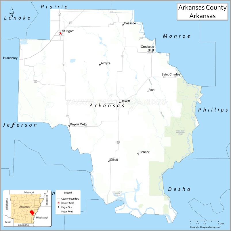
About Arkansas County Map, Arkansas: The map showing the county boundary, county seat, major cities, highways, water bodies and neighbouring counties.
Related Arkansas & US Links
Map of Arkansas County, Arkansas
"Arkansas County is a county located in the U.S. state of Arkansas. It's county seat is Stuttgart, DeWitt. As per 2020 census, the population of Arkansas County is 16722 people and population density is square miles. According to the United States Census Bureau, the county has a total area of 1,033.79 sq mi (2,678 km2). Arkansas County was established on -31428."
Arkansas County Facts
| Continent | North America |
| Country | United States |
| State | Arkansas |
| County Seats | DeWitt and Stuttgart |
| Largest City/Town | Stuttgart |
| Established | 1813 |
| Total Area | 1,033 sq mi (2,676 sq km) |
| Land Area | 989 sq mi (2,562 sq km) |
| Water Area | 44 sq mi (114 sq km) |
| Population | 17,149 (Census 2020) |
| Population Density | 17.3 people per sq mi |
| Time Zone | Central Time Zone (CST/CDT) |
| Major Highways | US Highway 79, US Highway 165, Arkansas Highway 1 |
| Major Rivers | White River, Arkansas River |
| Neighboring Counties | Prairie County, Monroe County, Phillips County, Desha County, Jefferson County, Lonoke County |
| Famous For | Rice farming, duck hunting, Stuttgart, and Grand Prairie agriculture |
| Top Attractions | Stuttgart duck hunting areas, Museum of the Arkansas Grand Prairie, White River National Wildlife Refuge |
| Official Website | Official Website |
About Arkansas County, Arkansas
Arkansas County is located in eastern Arkansas in the United States and was established in 1813, making it one of the oldest counties in the state. The county has two county seats, DeWitt and Stuttgart. Arkansas County is known for rice farming, waterfowl hunting, wetlands, and agricultural traditions in the Arkansas Grand Prairie region.
Cities and Towns in Arkansas County, Arkansas
| City/Town | Population (Census 2020) | Latitude & Longitude |
|---|---|---|
| Stuttgart | 8,264 | 34.5009°N, 91.5526°W |
| DeWitt (county seat) | 2,892 | 34.2920°N, 91.3379°W |
| Gillett | 691 | 34.1115°N, 91.3773°W |
| Humphrey (partly) | 451 | 34.4218°N, 91.6954°W |
| Almyra | 283 | 34.4120°N, 91.4096°W |
| Tichnor | Historic community | 34.0998°N, 91.2287°W |
| Crocketts Bluff area | Wetlands region | 34.4164°N, 91.2368°W |
| Arkansas Grand Prairie region | Agricultural landscape area | 34.3500°N, 91.4500°W |
Golf Courses in Arkansas County, Arkansas
| Golf Course | Location | Latitude & Longitude |
|---|---|---|
| Stuttgart Country Club | Stuttgart | 34.4864°N, 91.5439°W |
| DeWitt Country Club | DeWitt | 34.2911°N, 91.3417°W |
| Pine Bluff Country Club | Pine Bluff nearby | 34.2153°N, 92.0247°W |
Roads and Highways in Arkansas County, Arkansas
Major highways connect the county to eastern Arkansas agricultural communities and the Mississippi Delta region.
- US Highway 79 - major route linking Stuttgart, Pine Bluff, and central Arkansas
- US Highway 165 - north-south highway connecting agricultural communities across eastern Arkansas
- Arkansas Highway 1 - regional route serving Grand Prairie farming areas
What Are the Neighboring Counties of Arkansas County
- Prairie County (north)
- Monroe County (northeast)
- Phillips County (east)
- Desha County (south)
- Jefferson County (west)
- Lonoke County (northwest)
Whar Are the Top Attractions in Arkansas County, Arkansas
The county offers a mix of wildlife recreation, agricultural heritage, and outdoor attractions.
- White River National Wildlife Refuge - wetlands, birdwatching, fishing, and wildlife habitat
- Stuttgart duck hunting areas - internationally known waterfowl hunting destination
- Museum of the Arkansas Grand Prairie - exhibits on local farming and cultural history
- Arkansas Post National Memorial nearby - historic colonial and Civil War site
- Grand Prairie farming landscapes - scenic rice fields and agricultural scenery
- Annual Wings Over the Prairie Festival - waterfowl and outdoor recreation celebration
- Bayou Meto Wildlife Management Area nearby - hunting, fishing, and nature activities
- Historic Downtown Stuttgart - local shops, restaurants, and cultural attractions
- White River fishing areas - boating and outdoor recreation opportunities
- DeWitt historic district - courthouse square and local heritage sites
- Prairie wetlands and bird migration areas - wildlife photography and birdwatching opportunities
- Local fairs and agricultural festivals - celebrations of Arkansas farming traditions
What is the Distance from Arkansas County to Nearby Cities
The following distances are measured by road (driving).
- Stuttgart to Pine Bluff (Jefferson County), Arkansas - 44 mi (71 km)
- Stuttgart to Little Rock (Pulaski County), Arkansas - 55 mi (89 km)
- Stuttgart to Helena-West Helena (Phillips County), Arkansas - 88 mi (142 km)
- Stuttgart to Jonesboro (Craighead County), Arkansas - 126 mi (203 km)
- Stuttgart to Memphis (Shelby County), Tennessee - 118 mi (190 km)
- Stuttgart to Hot Springs (Garland County), Arkansas - 107 mi (172 km)
- Stuttgart to Texarkana (Miller County), Arkansas - 179 mi (288 km)
- Stuttgart to Jackson (Hinds County), Mississippi - 212 mi (341 km)
- Stuttgart to Shreveport (Caddo Parish), Louisiana - 242 mi (389 km)
- Stuttgart to Tulsa (Tulsa County), Oklahoma - 301 mi (484 km)
- Stuttgart to St. Louis (St. Louis City), Missouri - 358 mi (576 km)
- Stuttgart to Nashville (Davidson County), Tennessee - 340 mi (547 km)
FAQs about Arkansas County
Arkansas County is located in eastern Arkansas within the Arkansas Grand Prairie region of the United States.
The population of Arkansas County was 17,149 according to the Census 2020.
Arkansas County is known for rice farming, duck hunting, wetlands, and the city of Stuttgart.
The county is served by US Highway 79, US Highway 165, and Arkansas Highway 1.
Popular attractions include the White River National Wildlife Refuge, Stuttgart duck hunting areas, and the Museum of the Arkansas Grand Prairie.
References
- QuickFacts - U.S. Census Bureau
- United States Census Bureau
- United States Geological Survey (USGS)
- National Geodetic Survey
- Official Website
- Arkansas County Map
- Ashley County Map
- Baxter County Map
- Benton County Map
- Boone County Map
- Bradley County Map
- Calhoun County Map
- Carroll County Map
- Chicot County Map
- Clark County Map
- Clay County Map
- Cleburne County Map
- Cleveland County Map
- Columbia County Map
- Conway County Map
- Craighead County Map
- Crawford County Map
- Crittenden County Map
- Cross County Map
- Dallas County Map
- Desha County Map
- Drew County Map
- Faulkner County Map
- Franklin County Map
- Fulton County Map
- Garland County Map
- Grant County Map
- Greene County Map
- Hempstead County Map
- Hot Spring County Map
- Howard County Map
- Independence County Map
- Izard County Map
- Jackson County Map
- Jefferson County Map
- Johnson County Map
- Lafayette County Map
- Lawrence County Map
- Lee County Map
- Lincoln County Map
- Little River County Map
- Logan County Map
- Lonoke County Map
- Madison County Map
- Marion County Map
- Miller County Map
- Mississippi County Map
- Monroe County Map
- Montgomery County Map
- Nevada County Map
- Newton County Map
- Ouachita County Map
- Perry County Map
- Phillips County Map
- Pike County Map
- Poinsett County Map
- Polk County Map
- Pope County Map
- Prairie County Map
- Pulaski County Map
- Randolph County Map
- St Francis County Map
- Saline County Map
- Scott County Map
- Searcy County Map
- Sebastian County Map
- Sevier County Map
- Sharp County Map
- Stone County Map
- Union County Map
- Van Buren County Map
- Washington County Map
- White County Map
- Woodruff County Map
- Yell County Map
- Alabama Counties
- Alaska boroughs
- Arizona Counties
- Arkansas Counties
- California County Map
- Colorado Counties
- Connecticut Counties
- Delaware Counties
- Florida County Map
- Georgia County Map
- Hawaii Counties
- Idaho Counties
- Illinois Counties
- Indiana Counties
- Iowa Counties
- Kansas Counties
- Kentucky Counties
- Louisiana Counties
- Maine Counties
- Maryland Counties
- Massachusetts Counties
- Michigan County Map
- Minnesota Counties
- Mississippi Counties
- Missouri Counties
- Montana Counties
- Nebraska Counties
- Nevada Counties
- New York Counties
- New Hampshire Counties
- New Jersey Counties
- New Mexico Counties
- North Carolina Counties
- North Dakota Counties
- Ohio County Map
- Oklahoma Counties
- Oregon Counties
- Pennsylvania Counties
- Rhode Island Counties
- South Carolina Counties
- South Dakota Counties
- Map of Tennessee
- Texas County Map
- Utah Counties
- Vermont Counties
- Virginia Counties
- Washington Counties
- West Virginia Counties
- Wisconsin Counties
- Wyoming Counties