Written and Fact-checked by Whereig Editors, Reviewed by Mukesh Kumar| Last Updated On: May 10, 2026
Map of Grant County - Grant County is a county located in the U.S. state of Arkansas. Grant County Map showing cities, highways, important places and water bodies. Get Where is Grant County located in the map, major cities in Grant county, population, areas, and places of interest.
Grant County Map, Arkansas
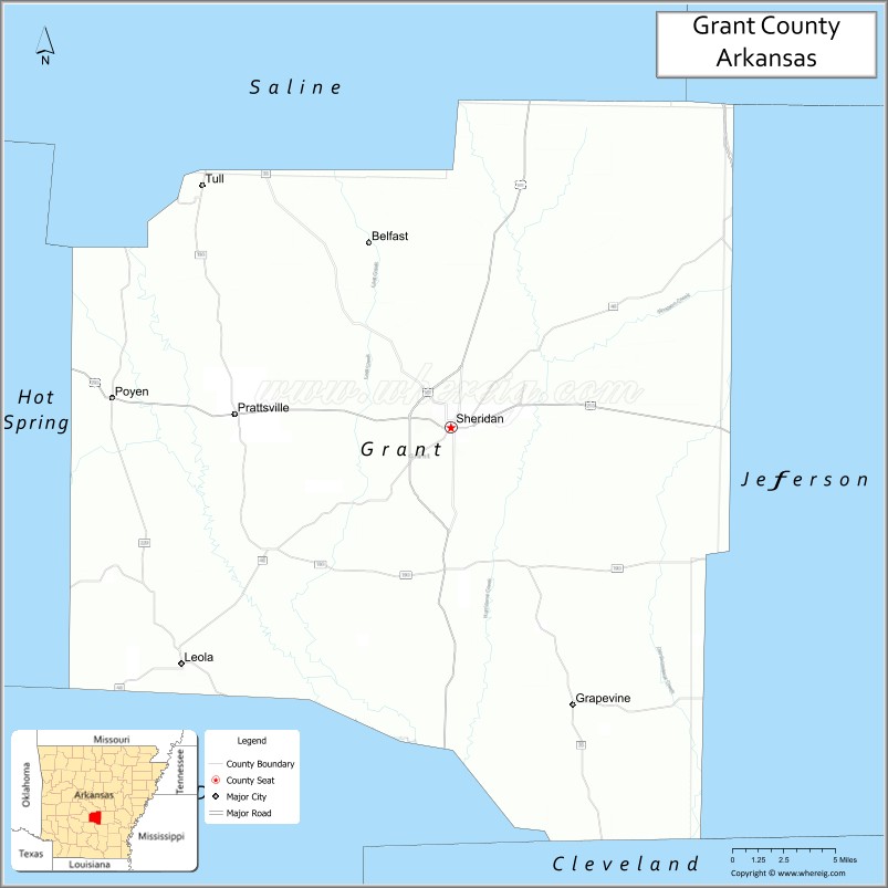
About Grant County Map, Arkansas: The map showing the county boundary, county seat, major cities, highways, water bodies and neighbouring counties.
Related Arkansas & US Links
Map of Grant County, Arkansas
Grant County is a county located in the U.S. state of Arkansas. It's county seat is Sheridan. As per 2020 census, the population of Grant County is 18090 people and population density is square miles. According to the United States Census Bureau, the county has a total area of 633.01 sq mi (1,639 km2). Grant County was established on -11286.
Grant County Facts
| Continent | North America |
| Country | United States |
| State | Arkansas |
| County Seat | Sheridan |
| Largest City/Town | Sheridan |
| Established | 1869 |
| Total Area | 633 sq mi (1,639 sq km) |
| Land Area | 632 sq mi (1,637 sq km) |
| Water Area | 1 sq mi (2 sq km) |
| Population | 17,958 (Census 2020) |
| Population Density | 28.4 people per sq mi |
| Time Zone | Central Time Zone (CST/CDT) |
| Major Highways | US Highway 167, Arkansas Highway 35, Arkansas Highway 46 |
| Major Rivers | Saline River |
| Neighboring Counties | Saline County, Jefferson County, Cleveland County, Hot Spring County, Dallas County |
| Famous For | Timber industry, rural Arkansas scenery, Saline River recreation, and outdoor activities |
| Top Attractions | Jenkins Ferry State Park nearby, Saline River, Sheridan downtown, outdoor recreation areas |
| Official Website | Official Website |
About Grant County, Arkansas
Grant County is located in central Arkansas in the United States and was established in 1869. The county seat and largest city is Sheridan. Grant County is known for pine forests, timber production, outdoor recreation, and its scenic rural landscapes between Little Rock and southern Arkansas.
Cities and Towns in Grant County, Arkansas
| City/Town | Population (Census 2020) | Latitude & Longitude |
|---|---|---|
| Sheridan (county seat) | 4,920 | 34.3068°N, 92.4015°W |
| Leola | 501 | 34.1665°N, 92.6732°W |
| Poyen | 290 | 34.3256°N, 92.6291°W |
| Prattsville | 305 | 34.3173°N, 92.5032°W |
| Tull | 448 | 34.4384°N, 92.5860°W |
| Kingsland | Historic community | 33.8773°N, 92.2946°W |
| Saline River region | Outdoor recreation area | 34.2500°N, 92.4500°W |
| Central Arkansas timber region | Forest landscape area | 34.3000°N, 92.4500°W |
Golf Courses in Grant County, Arkansas
| Golf Course | Location | Latitude & Longitude |
|---|---|---|
| Grant County Golf Club | Sheridan | 34.3094°N, 92.3965°W |
| Benton Country Club | Benton nearby | 34.5645°N, 92.5864°W |
| Pine Bluff Country Club | Pine Bluff nearby | 34.2153°N, 92.0247°W |
Roads and Highways in Grant County, Arkansas
Major highways connect the county to Little Rock, Pine Bluff, and southern Arkansas forest regions.
- US Highway 167 - major north-south highway linking Sheridan with Little Rock and El Dorado
- Arkansas Highway 35 - regional route through rural communities and timber regions
- Arkansas Highway 46 - east-west highway serving Grant County communities
What Are the Neighboring Counties of Grant County
- Saline County (north)
- Jefferson County (east)
- Cleveland County (south)
- Hot Spring County (west)
- Dallas County (southwest)
Whar Are the Top Attractions in Grant County, Arkansas
The county offers a mix of outdoor recreation, historical sites, and scenic countryside.
- Saline River recreation areas - kayaking, fishing, swimming, and nature activities
- Jenkins Ferry State Park nearby - Civil War history and scenic picnic areas
- Historic downtown Sheridan - local restaurants, shops, and community events
- Pine forest scenic drives - woodland landscapes and wildlife viewing
- Fishing lakes and rural recreation sites - camping and family outdoor activities
- Community fairs and county festivals - celebrations of Arkansas traditions and culture
- Nature trails and wildlife habitats - birdwatching and photography opportunities
- Historic churches and courthouse district - architectural and cultural landmarks
- Timber industry heritage areas - reminders of the county’s forestry economy
- Outdoor hunting and recreation lands - popular sportsman destinations
- Nearby Little Rock regional attractions access - day-trip tourism opportunities
- Rural Arkansas backroads and countryside scenery - peaceful outdoor exploration
What is the Distance from Grant County to Nearby Cities
The following distances are measured by road (driving).
- Sheridan to Little Rock (Pulaski County), Arkansas - 34 mi (55 km)
- Sheridan to Benton (Saline County), Arkansas - 24 mi (39 km)
- Sheridan to Pine Bluff (Jefferson County), Arkansas - 33 mi (53 km)
- Sheridan to Hot Springs (Garland County), Arkansas - 50 mi (80 km)
- Sheridan to El Dorado (Union County), Arkansas - 92 mi (148 km)
- Sheridan to Conway (Faulkner County), Arkansas - 61 mi (98 km)
- Sheridan to Texarkana (Miller County), Arkansas - 132 mi (212 km)
- Sheridan to Memphis (Shelby County), Tennessee - 170 mi (274 km)
- Sheridan to Shreveport (Caddo Parish), Louisiana - 176 mi (283 km)
- Sheridan to Dallas (Dallas County), Texas - 296 mi (476 km)
- Sheridan to Jackson (Hinds County), Mississippi - 210 mi (338 km)
- Sheridan to St. Louis (St. Louis City), Missouri - 390 mi (628 km)
FAQs about Grant County
Grant County is located in central Arkansas in the United States.
The population of Grant County was 17,958 according to the Census 2020.
Grant County is known for pine forests, timber industries, outdoor recreation, and Saline River activities.
The county is served by US Highway 167, Arkansas Highway 35, and Arkansas Highway 46.
Popular attractions include Saline River recreation areas, Jenkins Ferry State Park nearby, Sheridan downtown, and forest recreation sites.
References
- QuickFacts - U.S. Census Bureau
- United States Census Bureau
- United States Geological Survey (USGS)
- National Geodetic Survey
- Official Website
- Arkansas County Map
- Ashley County Map
- Baxter County Map
- Benton County Map
- Boone County Map
- Bradley County Map
- Calhoun County Map
- Carroll County Map
- Chicot County Map
- Clark County Map
- Clay County Map
- Cleburne County Map
- Cleveland County Map
- Columbia County Map
- Conway County Map
- Craighead County Map
- Crawford County Map
- Crittenden County Map
- Cross County Map
- Dallas County Map
- Desha County Map
- Drew County Map
- Faulkner County Map
- Franklin County Map
- Fulton County Map
- Garland County Map
- Grant County Map
- Greene County Map
- Hempstead County Map
- Hot Spring County Map
- Howard County Map
- Independence County Map
- Izard County Map
- Jackson County Map
- Jefferson County Map
- Johnson County Map
- Lafayette County Map
- Lawrence County Map
- Lee County Map
- Lincoln County Map
- Little River County Map
- Logan County Map
- Lonoke County Map
- Madison County Map
- Marion County Map
- Miller County Map
- Mississippi County Map
- Monroe County Map
- Montgomery County Map
- Nevada County Map
- Newton County Map
- Ouachita County Map
- Perry County Map
- Phillips County Map
- Pike County Map
- Poinsett County Map
- Polk County Map
- Pope County Map
- Prairie County Map
- Pulaski County Map
- Randolph County Map
- St Francis County Map
- Saline County Map
- Scott County Map
- Searcy County Map
- Sebastian County Map
- Sevier County Map
- Sharp County Map
- Stone County Map
- Union County Map
- Van Buren County Map
- Washington County Map
- White County Map
- Woodruff County Map
- Yell County Map
- Alabama Counties
- Alaska boroughs
- Arizona Counties
- Arkansas Counties
- California County Map
- Colorado Counties
- Connecticut Counties
- Delaware Counties
- Florida County Map
- Georgia County Map
- Hawaii Counties
- Idaho Counties
- Illinois Counties
- Indiana Counties
- Iowa Counties
- Kansas Counties
- Kentucky Counties
- Louisiana Counties
- Maine Counties
- Maryland Counties
- Massachusetts Counties
- Michigan County Map
- Minnesota Counties
- Mississippi Counties
- Missouri Counties
- Montana Counties
- Nebraska Counties
- Nevada Counties
- New York Counties
- New Hampshire Counties
- New Jersey Counties
- New Mexico Counties
- North Carolina Counties
- North Dakota Counties
- Ohio County Map
- Oklahoma Counties
- Oregon Counties
- Pennsylvania Counties
- Rhode Island Counties
- South Carolina Counties
- South Dakota Counties
- Map of Tennessee
- Texas County Map
- Utah Counties
- Vermont Counties
- Virginia Counties
- Washington Counties
- West Virginia Counties
- Wisconsin Counties
- Wyoming Counties