Written and Fact-checked by Whereig Editors, Reviewed by Mukesh Kumar| Last Updated On: May 10, 2026
Map of Union County - Union County is a county located in the U.S. state of Arkansas. Union County Map showing cities, highways, important places and water bodies. Get Where is Union County located in the map, major cities in Union county, population, areas, and places of interest.
Union County Map, Arkansas
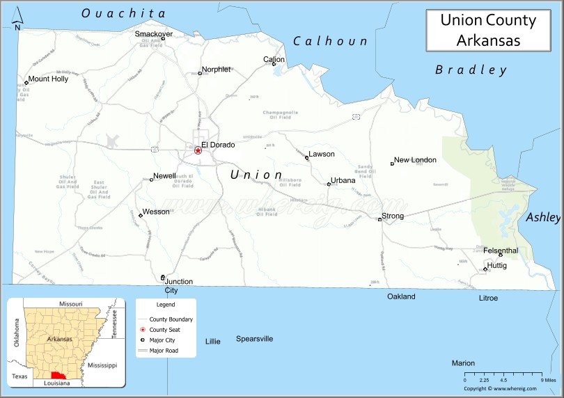
About Union County Map, Arkansas: The map showing the county boundary, county seat, major cities, highways, water bodies and neighbouring counties.
Related Arkansas & US Links
Map of Union County, Arkansas
Union County is a county located in the U.S. state of Arkansas. It's county seat is El Dorado. As per 2020 census, the population of Union County is 38340 people and population density is square miles. According to the United States Census Bureau, the county has a total area of 1,055.27 sq mi (2,733 km2). Union County was established on -25625.
Union County Facts
| Continent | North America |
| Country | United States |
| State | Arkansas |
| County Seat | El Dorado |
| Largest City/Town | El Dorado |
| Established | November 2, 1829 |
| Total Area | 1,055 sq mi (2,732 sq km) |
| Land Area | 1,039 sq mi (2,691 sq km) |
| Water Area | 16 sq mi (41 sq km) |
| Population | 39,054 (Census 2020) |
| Population Density | 37.6 people per sq mi |
| Time Zone | Central Time Zone (CT) |
| Major Highways | US 82, US 167, AR 7, AR 15, AR 335 |
| Major Rivers | Ouachita River |
| Neighboring Counties | Ouachita County, Columbia County, Calhoun County, Claiborne Parish (LA), Union Parish (LA) |
| Famous For | El Dorado oil boom, Murphy Arts District, South Arkansas culture, timber industry |
| Top Attractions | Murphy Arts District, South Arkansas Arboretum, Arkansas Museum of Natural Resources, El Dorado Downtown Historic District |
| Official Website | Official Website |
About Union County, Arkansas
Union County is located in southern Arkansas in the United States and was established in 1829. The county seat is El Dorado, which is also the largest city in the county. The county is known for its historic oil boom, arts and entertainment venues, forests, and role as a major economic center in southern Arkansas.
Cities and Towns in Union County, Arkansas
| City/Town | Population (Census 2020) | Latitude & Longitude |
|---|---|---|
| El Dorado (county seat) | 17,756 | 33.2076°N, 92.6663°W |
| Calion | 449 | 33.3334°N, 92.5410°W |
| Felsenthal | 85 | 33.0607°N, 92.1754°W |
| Huttig | 448 | 33.0404°N, 92.1829°W |
| Junction City | 523 | 33.0185°N, 92.7240°W |
| Lawson | 368 | 33.2729°N, 92.4259°W |
| Mount Holly | 286 | 33.3287°N, 92.9640°W |
| Norphlet | 844 | 33.3154°N, 92.6621°W |
| Smackover | 1,630 | 33.3657°N, 92.7243°W |
| Strong | 462 | 33.1071°N, 92.3557°W |
Golf Courses in Union County, Arkansas
| Golf Course | Location | Latitude & Longitude |
|---|---|---|
| Lion Oil Golf Course | El Dorado | 33.2218°N, 92.6825°W |
| Mystic Creek Golf Club | El Dorado | 33.1658°N, 92.7081°W |
| El Dorado Golf and Country Club | El Dorado | 33.2074°N, 92.6908°W |
Roads and Highways in Union County, Arkansas
Major highways connect the county to Louisiana and other regions of Arkansas.
- US Highway 82 - major east-west route through El Dorado and southern Arkansas
- US Highway 167 - north-south corridor connecting El Dorado with Little Rock and Louisiana
- Arkansas Highway 7 - scenic route linking southern Arkansas communities
- Arkansas Highway 15 - regional highway serving rural communities and forested areas
- Arkansas Highway 335 - local roadway connecting smaller towns and recreation sites
What Are the Neighboring Counties of Union County
- Ouachita County (north)
- Calhoun County (northeast)
- Columbia County (west)
- Union Parish, Louisiana (south)
- Claiborne Parish, Louisiana (southeast)
Whar Are the Top Attractions in Union County, Arkansas
The county offers a mix of natural and cultural attractions.
- Murphy Arts District - entertainment district featuring concerts, restaurants, and cultural venues
- South Arkansas Arboretum - botanical and nature area with walking trails and native plants
- Arkansas Museum of Natural Resources - museum highlighting the oil and brine industries of Arkansas
- El Dorado Downtown Historic District - revitalized downtown area with historic architecture and shopping
- Mystic Creek Golf Club - nationally recognized golf course in a forested setting
- South Arkansas Arts Center - performing arts venue and regional cultural institution
- Felsenthal National Wildlife Refuge nearby - wildlife refuge known for birdwatching and wetlands
- Newton House Museum - preserved historic home and local history museum
- Mattocks Park - public recreation area with sports and picnic facilities
- Smackover Oil Field Heritage Area - historic region tied to Arkansas oil history
- Ouachita River recreation areas - boating, fishing, and outdoor recreation destinations
- Union County Courthouse - historic courthouse building in downtown El Dorado
- South Arkansas Symphony performances - cultural events held throughout the year
What is the Distance from Union County to Nearby Cities
The following distances are measured by road (driving).
- El Dorado to Little Rock (Pulaski County), Arkansas - 121 mi (195 km)
- El Dorado to Shreveport (Caddo Parish), Louisiana - 71 mi (114 km)
- El Dorado to Monroe (Ouachita Parish), Louisiana - 73 mi (117 km)
- El Dorado to Camden (Ouachita County), Arkansas - 35 mi (56 km)
- El Dorado to Magnolia (Columbia County), Arkansas - 38 mi (61 km)
- El Dorado to Pine Bluff (Jefferson County), Arkansas - 86 mi (138 km)
- El Dorado to Texarkana (Miller County), Arkansas - 101 mi (163 km)
- El Dorado to Hot Springs (Garland County), Arkansas - 116 mi (187 km)
- El Dorado to Ruston (Lincoln Parish), Louisiana - 53 mi (85 km)
- El Dorado to Fayetteville (Washington County), Arkansas - 293 mi (472 km)
- El Dorado to Dallas (Dallas County), Texas - 273 mi (439 km)
- El Dorado to Baton Rouge (East Baton Rouge Parish), Louisiana - 229 mi (369 km)
FAQs about Union County
Union County is located in southern Arkansas near the Louisiana border.
Union County had a population of 39,054 according to the 2020 United States Census.
Union County is known for the El Dorado oil boom, arts and entertainment, forests, and southern Arkansas culture.
The major highways include US Highway 82, US Highway 167, Arkansas Highway 7, Arkansas Highway 15, and Arkansas Highway 335.
Yes, Union County has several golf facilities including Mystic Creek Golf Club and El Dorado Golf and Country Club.
References
- QuickFacts - U.S. Census Bureau
- United States Census Bureau
- United States Geological Survey (USGS)
- National Geodetic Survey
- Official Website
- Arkansas County Map
- Ashley County Map
- Baxter County Map
- Benton County Map
- Boone County Map
- Bradley County Map
- Calhoun County Map
- Carroll County Map
- Chicot County Map
- Clark County Map
- Clay County Map
- Cleburne County Map
- Cleveland County Map
- Columbia County Map
- Conway County Map
- Craighead County Map
- Crawford County Map
- Crittenden County Map
- Cross County Map
- Dallas County Map
- Desha County Map
- Drew County Map
- Faulkner County Map
- Franklin County Map
- Fulton County Map
- Garland County Map
- Grant County Map
- Greene County Map
- Hempstead County Map
- Hot Spring County Map
- Howard County Map
- Independence County Map
- Izard County Map
- Jackson County Map
- Jefferson County Map
- Johnson County Map
- Lafayette County Map
- Lawrence County Map
- Lee County Map
- Lincoln County Map
- Little River County Map
- Logan County Map
- Lonoke County Map
- Madison County Map
- Marion County Map
- Miller County Map
- Mississippi County Map
- Monroe County Map
- Montgomery County Map
- Nevada County Map
- Newton County Map
- Ouachita County Map
- Perry County Map
- Phillips County Map
- Pike County Map
- Poinsett County Map
- Polk County Map
- Pope County Map
- Prairie County Map
- Pulaski County Map
- Randolph County Map
- St Francis County Map
- Saline County Map
- Scott County Map
- Searcy County Map
- Sebastian County Map
- Sevier County Map
- Sharp County Map
- Stone County Map
- Union County Map
- Van Buren County Map
- Washington County Map
- White County Map
- Woodruff County Map
- Yell County Map
- Alabama Counties
- Alaska boroughs
- Arizona Counties
- Arkansas Counties
- California County Map
- Colorado Counties
- Connecticut Counties
- Delaware Counties
- Florida County Map
- Georgia County Map
- Hawaii Counties
- Idaho Counties
- Illinois Counties
- Indiana Counties
- Iowa Counties
- Kansas Counties
- Kentucky Counties
- Louisiana Counties
- Maine Counties
- Maryland Counties
- Massachusetts Counties
- Michigan County Map
- Minnesota Counties
- Mississippi Counties
- Missouri Counties
- Montana Counties
- Nebraska Counties
- Nevada Counties
- New York Counties
- New Hampshire Counties
- New Jersey Counties
- New Mexico Counties
- North Carolina Counties
- North Dakota Counties
- Ohio County Map
- Oklahoma Counties
- Oregon Counties
- Pennsylvania Counties
- Rhode Island Counties
- South Carolina Counties
- South Dakota Counties
- Map of Tennessee
- Texas County Map
- Utah Counties
- Vermont Counties
- Virginia Counties
- Washington Counties
- West Virginia Counties
- Wisconsin Counties
- Wyoming Counties