Written and Fact-checked by Whereig Editors, Reviewed by Mukesh Kumar| Last Updated On: May 10, 2026
Map of Boone County - Boone County is a county located in the U.S. state of Arkansas. Boone County Map showing cities, highways, important places and water bodies. Get Where is Boone County located in the map, major cities in Boone county, population, areas, and places of interest.
Boone County Map, Arkansas
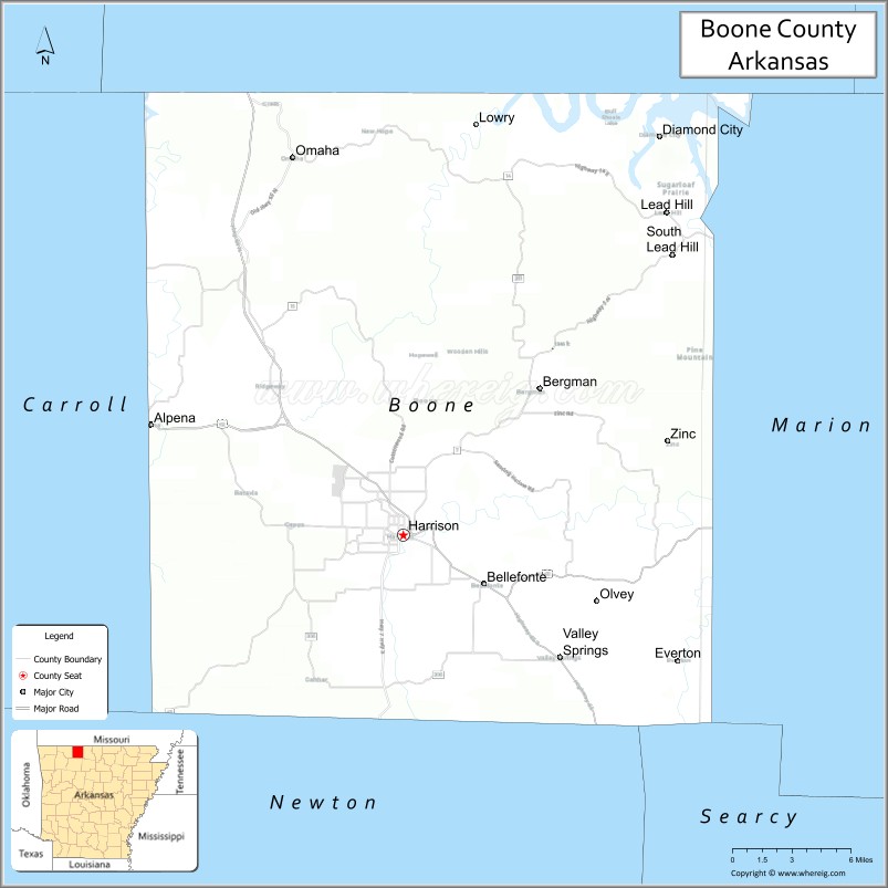
About Boone County Map, Arkansas: The map showing the county boundary, county seat, major cities, highways, water bodies and neighbouring counties.
Related Arkansas & US Links
Map of Boone County, Arkansas
Boone County is a county located in the U.S. state of Arkansas. It's county seat is Harrison. As per 2020 census, the population of Boone County is 37830 people and population density is square miles. According to the United States Census Bureau, the county has a total area of 601.82 sq mi (1,559 km2). Boone County was established on -11222.
Boone County Facts
| Continent | North America |
| Country | United States |
| State | Arkansas |
| County Seat | Harrison |
| Largest City/Town | Harrison |
| Established | 1869 |
| Total Area | 602 sq mi (1,559 sq km) |
| Land Area | 590 sq mi (1,528 sq km) |
| Water Area | 12 sq mi (31 sq km) |
| Population | 37,373 (Census 2020) |
| Population Density | 63.3 people per sq mi |
| Time Zone | Central Time Zone (CST/CDT) |
| Major Highways | US Highway 65, US Highway 62, US Highway 412, Arkansas Highway 7 |
| Major Rivers | Buffalo River, White River |
| Neighboring Counties | Marion County, Newton County, Carroll County, Searcy County, Taney County (MO) |
| Famous For | Ozark Mountains, Buffalo National River access, outdoor recreation, and scenic landscapes |
| Top Attractions | Buffalo National River, Mystic Caverns, Hemmed-In Hollow access, Ozark Mountains scenery |
| Official Website | Official Website |
About Boone County, Arkansas
Boone County is located in north-central Arkansas in the United States and was established in 1869. The county seat and largest city is Harrison. Boone County is known for Ozark Mountain scenery, outdoor recreation, caves, rivers, hiking, and tourism connected to the Buffalo National River region.
Cities and Towns in Boone County, Arkansas
| City/Town | Population (Census 2020) | Latitude & Longitude |
|---|---|---|
| Harrison (county seat) | 13,069 | 36.2298°N, 93.1077°W |
| Alpena | 392 | 36.2956°N, 93.2935°W |
| Bellefonte | 454 | 36.2009°N, 93.0510°W |
| Bergman | 439 | 36.3156°N, 93.0177°W |
| Diamond City (partly) | 757 | 36.4487°N, 92.9202°W |
| Everton | 104 | 36.1515°N, 92.9935°W |
| Lead Hill | 261 | 36.4220°N, 92.9129°W |
| Omaha | 128 | 36.4545°N, 93.1882°W |
| Valley Springs | 183 | 36.1551°N, 92.9930°W |
| Zinc | 92 | 36.2962°N, 92.9154°W |
| Buffalo River region | Scenic recreation area | 36.0400°N, 92.9100°W |
| Ozark Mountain region | Mountain landscape area | 36.2000°N, 93.1000°W |
Golf Courses in Boone County, Arkansas
| Golf Course | Location | Latitude & Longitude |
|---|---|---|
| Harrison Country Club | Harrison | 36.2336°N, 93.1102°W |
| Big Cedar Lodge Golf Courses | Ridgedale nearby, Missouri | 36.5172°N, 93.2189°W |
| Top of the Rock Golf Course | Ridgedale nearby, Missouri | 36.5344°N, 93.2867°W |
Roads and Highways in Boone County, Arkansas
Major highways connect the county to the Ozark Mountains, Missouri, and northern Arkansas recreation destinations.
- US Highway 65 - major north-south highway linking Harrison with Branson and Little Rock
- US Highway 62 - east-west route connecting Boone County with northwest Arkansas communities
- US Highway 412 - regional highway serving northern Arkansas and Oklahoma
- Arkansas Highway 7 - scenic route through the Ozark Mountains and river valleys
What Are the Neighboring Counties of Boone County
- Marion County (east)
- Newton County (south)
- Searcy County (southwest)
- Carroll County (west)
- Taney County, Missouri (north)
Whar Are the Top Attractions in Boone County, Arkansas
The county offers a mix of mountain scenery, caves, hiking, and outdoor recreation attractions.
- Buffalo National River access areas - floating, hiking, camping, and scenic river recreation
- Mystic Caverns and Crystal Dome Caverns - guided cave tours and underground formations
- Hemmed-In Hollow Falls access trails - hiking routes to one of the tallest waterfalls in the region
- Ozark Mountain scenic drives - panoramic overlooks and forest landscapes
- Harrison historic downtown - local shops, restaurants, and cultural attractions
- Buffalo River wilderness trails - hiking and wildlife viewing opportunities
- Bull Shoals Lake nearby recreation areas - boating and fishing destinations
- Maplewood Cemetery and historic sites - local heritage landmarks
- Crooked Creek recreation areas - fishing, kayaking, and nature activities
- Branson entertainment access nearby - music theaters and tourism attractions
- Ozark National Forest access routes nearby - camping and hiking opportunities
- Local craft fairs and mountain festivals - celebrations of Ozark culture and traditions
What is the Distance from Boone County to Nearby Cities
The following distances are measured by road (driving).
- Harrison to Branson (Taney County), Missouri - 35 mi (56 km)
- Harrison to Mountain Home (Baxter County), Arkansas - 52 mi (84 km)
- Harrison to Fayetteville (Washington County), Arkansas - 87 mi (140 km)
- Harrison to Springfield (Greene County), Missouri - 88 mi (142 km)
- Harrison to Little Rock (Pulaski County), Arkansas - 129 mi (208 km)
- Harrison to Fort Smith (Sebastian County), Arkansas - 132 mi (212 km)
- Harrison to Tulsa (Tulsa County), Oklahoma - 202 mi (325 km)
- Harrison to Memphis (Shelby County), Tennessee - 261 mi (420 km)
- Harrison to Kansas City (Jackson County), Missouri - 247 mi (398 km)
- Harrison to St. Louis (St. Louis City), Missouri - 284 mi (457 km)
- Harrison to Oklahoma City (Oklahoma County), Oklahoma - 285 mi (459 km)
- Harrison to Dallas (Dallas County), Texas - 404 mi (650 km)
FAQs about Boone County
Boone County is located in north-central Arkansas within the Ozark Mountains region of the United States.
The population of Boone County was 37,373 according to the Census 2020.
Boone County is known for the Ozark Mountains, Buffalo National River access, caves, and outdoor recreation.
The county is served by US Highway 65, US Highway 62, US Highway 412, and Arkansas Highway 7.
Popular attractions include the Buffalo National River, Mystic Caverns, Hemmed-In Hollow trails, and scenic Ozark Mountain drives.
References
- QuickFacts - U.S. Census Bureau
- United States Census Bureau
- United States Geological Survey (USGS)
- National Geodetic Survey
- Official Website
- Arkansas County Map
- Ashley County Map
- Baxter County Map
- Benton County Map
- Boone County Map
- Bradley County Map
- Calhoun County Map
- Carroll County Map
- Chicot County Map
- Clark County Map
- Clay County Map
- Cleburne County Map
- Cleveland County Map
- Columbia County Map
- Conway County Map
- Craighead County Map
- Crawford County Map
- Crittenden County Map
- Cross County Map
- Dallas County Map
- Desha County Map
- Drew County Map
- Faulkner County Map
- Franklin County Map
- Fulton County Map
- Garland County Map
- Grant County Map
- Greene County Map
- Hempstead County Map
- Hot Spring County Map
- Howard County Map
- Independence County Map
- Izard County Map
- Jackson County Map
- Jefferson County Map
- Johnson County Map
- Lafayette County Map
- Lawrence County Map
- Lee County Map
- Lincoln County Map
- Little River County Map
- Logan County Map
- Lonoke County Map
- Madison County Map
- Marion County Map
- Miller County Map
- Mississippi County Map
- Monroe County Map
- Montgomery County Map
- Nevada County Map
- Newton County Map
- Ouachita County Map
- Perry County Map
- Phillips County Map
- Pike County Map
- Poinsett County Map
- Polk County Map
- Pope County Map
- Prairie County Map
- Pulaski County Map
- Randolph County Map
- St Francis County Map
- Saline County Map
- Scott County Map
- Searcy County Map
- Sebastian County Map
- Sevier County Map
- Sharp County Map
- Stone County Map
- Union County Map
- Van Buren County Map
- Washington County Map
- White County Map
- Woodruff County Map
- Yell County Map
- Alabama Counties
- Alaska boroughs
- Arizona Counties
- Arkansas Counties
- California County Map
- Colorado Counties
- Connecticut Counties
- Delaware Counties
- Florida County Map
- Georgia County Map
- Hawaii Counties
- Idaho Counties
- Illinois Counties
- Indiana Counties
- Iowa Counties
- Kansas Counties
- Kentucky Counties
- Louisiana Counties
- Maine Counties
- Maryland Counties
- Massachusetts Counties
- Michigan County Map
- Minnesota Counties
- Mississippi Counties
- Missouri Counties
- Montana Counties
- Nebraska Counties
- Nevada Counties
- New York Counties
- New Hampshire Counties
- New Jersey Counties
- New Mexico Counties
- North Carolina Counties
- North Dakota Counties
- Ohio County Map
- Oklahoma Counties
- Oregon Counties
- Pennsylvania Counties
- Rhode Island Counties
- South Carolina Counties
- South Dakota Counties
- Map of Tennessee
- Texas County Map
- Utah Counties
- Vermont Counties
- Virginia Counties
- Washington Counties
- West Virginia Counties
- Wisconsin Counties
- Wyoming Counties