Written and Fact-checked by Whereig Editors, Reviewed by Mukesh Kumar| Last Updated On: May 10, 2026
Map of Carroll County - Carroll County is a county located in the U.S. state of Arkansas. Carroll County Map showing cities, highways, important places and water bodies. Get Where is Carroll County located in the map, major cities in Carroll county, population, areas, and places of interest.
Carroll County Map, Arkansas
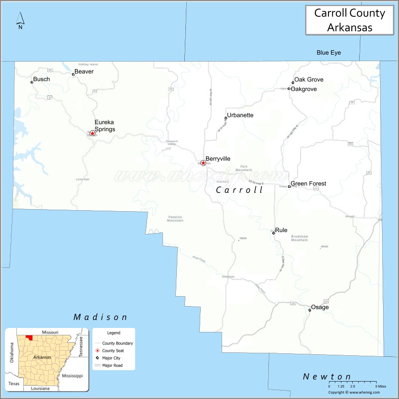
About Carroll County Map, Arkansas: The map showing the county boundary, county seat, major cities, highways, water bodies and neighbouring counties.
Related Arkansas & US Links
Map of Carroll County, Arkansas
"Carroll County is a county located in the U.S. state of Arkansas. It's county seat is Berryville, Eureka Springs. As per 2020 census, the population of Carroll County is 28435 people and population density is square miles. According to the United States Census Bureau, the county has a total area of 638.81 sq mi (1,655 km2). Carroll County was established on -24165."
Carroll County Facts
| Continent | North America |
| Country | United States |
| State | Arkansas |
| County Seats | Berryville and Eureka Springs |
| Largest City/Town | Berryville |
| Established | 1833 |
| Total Area | 639 sq mi (1,655 sq km) |
| Land Area | 630 sq mi (1,632 sq km) |
| Water Area | 9 sq mi (23 sq km) |
| Population | 28,260 (Census 2020) |
| Population Density | 44.9 people per sq mi |
| Time Zone | Central Time Zone (CST/CDT) |
| Major Highways | US Highway 62, US Highway 412, Arkansas Highway 23 |
| Major Rivers | White River, Kings River |
| Neighboring Counties | Boone County, Madison County, Benton County, Newton County, Stone County (MO), Taney County (MO) |
| Famous For | Eureka Springs, Ozark Mountains, Beaver Lake, and scenic tourism |
| Top Attractions | Eureka Springs Historic District, Thorncrown Chapel, Beaver Lake, Turpentine Creek Wildlife Refuge |
| Official Website | Official Website |
About Carroll County, Arkansas
Carroll County is located in northwestern Arkansas in the United States and was established in 1833. The county has two county seats, Berryville and Eureka Springs. Carroll County is known for scenic Ozark Mountain landscapes, tourism, lakes, historic architecture, outdoor recreation, and the famous resort town of Eureka Springs.
Cities and Towns in Carroll County, Arkansas
| City/Town | Population (Census 2020) | Latitude & Longitude |
|---|---|---|
| Berryville (county seat) | 5,356 | 36.3648°N, 93.5671°W |
| Eureka Springs (county seat) | 2,166 | 36.4012°N, 93.7379°W |
| Green Forest | 2,972 | 36.3353°N, 93.4202°W |
| Holiday Island | 2,533 | 36.4856°N, 93.7305°W |
| Alpena (partly) | 392 | 36.2956°N, 93.2935°W |
| Oak Grove | 369 | 36.4612°N, 93.4318°W |
| Beaver Lake region | Outdoor recreation area | 36.4300°N, 93.7000°W |
| Ozark Mountain region | Scenic mountain landscape | 36.4000°N, 93.6000°W |
Golf Courses in Carroll County, Arkansas
| Golf Course | Location | Latitude & Longitude |
|---|---|---|
| Holiday Island Golf Course | Holiday Island | 36.4892°N, 93.7286°W |
| Berryville Country Club | Berryville | 36.3642°N, 93.5631°W |
| Big Cedar Lodge Golf Courses | Ridgedale nearby, Missouri | 36.5172°N, 93.2189°W |
Roads and Highways in Carroll County, Arkansas
Major highways connect the county to the Ozark Mountains, Missouri, and Northwest Arkansas tourism regions.
- US Highway 62 - major east-west route linking Berryville, Eureka Springs, and northern Arkansas communities
- US Highway 412 - regional highway connecting the county with Oklahoma and Missouri
- Arkansas Highway 23 - scenic mountain highway known as the Pig Trail route in Arkansas
What Are the Neighboring Counties of Carroll County
- Boone County (east)
- Madison County (south)
- Benton County (west)
- Newton County (southeast)
- Stone County, Missouri (north)
- Taney County, Missouri (northeast)
Whar Are the Top Attractions in Carroll County, Arkansas
The county offers a mix of mountain scenery, historic tourism, and outdoor recreation attractions.
- Eureka Springs Historic District - Victorian architecture, shops, galleries, and mountain streets
- Thorncrown Chapel - internationally recognized glass chapel in the Ozarks
- Beaver Lake - boating, fishing, swimming, and lakeside recreation
- Turpentine Creek Wildlife Refuge - sanctuary for rescued big cats and wildlife education
- Christ of the Ozarks statue - iconic mountaintop religious landmark
- Great Passion Play grounds - outdoor religious drama and cultural attractions
- Kings River recreation areas - floating, fishing, and scenic outdoor activities
- Historic Basin Park in Eureka Springs - community events and entertainment destination
- Ozark Mountain scenic drives - panoramic overlooks and winding mountain roads
- Onyx Cave Park - cave tours and geological attractions
- Holiday Island recreation areas - golf, boating, and lake activities
- Blue Spring Heritage Center nearby - gardens, springs, and Native American history exhibits
What is the Distance from Carroll County to Nearby Cities
The following distances are measured by road (driving).
- Berryville to Eureka Springs (Carroll County), Arkansas - 11 mi (18 km)
- Berryville to Harrison (Boone County), Arkansas - 31 mi (50 km)
- Berryville to Bentonville (Benton County), Arkansas - 45 mi (72 km)
- Berryville to Fayetteville (Washington County), Arkansas - 58 mi (93 km)
- Berryville to Branson (Taney County), Missouri - 49 mi (79 km)
- Berryville to Springfield (Greene County), Missouri - 87 mi (140 km)
- Berryville to Fort Smith (Sebastian County), Arkansas - 120 mi (193 km)
- Berryville to Tulsa (Tulsa County), Oklahoma - 167 mi (269 km)
- Berryville to Little Rock (Pulaski County), Arkansas - 181 mi (291 km)
- Berryville to Kansas City (Jackson County), Missouri - 233 mi (375 km)
- Berryville to St. Louis (St. Louis City), Missouri - 311 mi (500 km)
- Berryville to Dallas (Dallas County), Texas - 392 mi (631 km)
FAQs about Carroll County
Carroll County is located in northwestern Arkansas within the Ozark Mountains region of the United States.
The population of Carroll County was 28,260 according to the Census 2020.
Carroll County is known for Eureka Springs, Beaver Lake, Ozark Mountain scenery, and tourism attractions.
The county is served by US Highway 62, US Highway 412, and Arkansas Highway 23.
Popular attractions include Eureka Springs Historic District, Thorncrown Chapel, Beaver Lake, and Turpentine Creek Wildlife Refuge.
References
- QuickFacts - U.S. Census Bureau
- United States Census Bureau
- United States Geological Survey (USGS)
- National Geodetic Survey
- Official Website
- Arkansas County Map
- Ashley County Map
- Baxter County Map
- Benton County Map
- Boone County Map
- Bradley County Map
- Calhoun County Map
- Carroll County Map
- Chicot County Map
- Clark County Map
- Clay County Map
- Cleburne County Map
- Cleveland County Map
- Columbia County Map
- Conway County Map
- Craighead County Map
- Crawford County Map
- Crittenden County Map
- Cross County Map
- Dallas County Map
- Desha County Map
- Drew County Map
- Faulkner County Map
- Franklin County Map
- Fulton County Map
- Garland County Map
- Grant County Map
- Greene County Map
- Hempstead County Map
- Hot Spring County Map
- Howard County Map
- Independence County Map
- Izard County Map
- Jackson County Map
- Jefferson County Map
- Johnson County Map
- Lafayette County Map
- Lawrence County Map
- Lee County Map
- Lincoln County Map
- Little River County Map
- Logan County Map
- Lonoke County Map
- Madison County Map
- Marion County Map
- Miller County Map
- Mississippi County Map
- Monroe County Map
- Montgomery County Map
- Nevada County Map
- Newton County Map
- Ouachita County Map
- Perry County Map
- Phillips County Map
- Pike County Map
- Poinsett County Map
- Polk County Map
- Pope County Map
- Prairie County Map
- Pulaski County Map
- Randolph County Map
- St Francis County Map
- Saline County Map
- Scott County Map
- Searcy County Map
- Sebastian County Map
- Sevier County Map
- Sharp County Map
- Stone County Map
- Union County Map
- Van Buren County Map
- Washington County Map
- White County Map
- Woodruff County Map
- Yell County Map
- Alabama Counties
- Alaska boroughs
- Arizona Counties
- Arkansas Counties
- California County Map
- Colorado Counties
- Connecticut Counties
- Delaware Counties
- Florida County Map
- Georgia County Map
- Hawaii Counties
- Idaho Counties
- Illinois Counties
- Indiana Counties
- Iowa Counties
- Kansas Counties
- Kentucky Counties
- Louisiana Counties
- Maine Counties
- Maryland Counties
- Massachusetts Counties
- Michigan County Map
- Minnesota Counties
- Mississippi Counties
- Missouri Counties
- Montana Counties
- Nebraska Counties
- Nevada Counties
- New York Counties
- New Hampshire Counties
- New Jersey Counties
- New Mexico Counties
- North Carolina Counties
- North Dakota Counties
- Ohio County Map
- Oklahoma Counties
- Oregon Counties
- Pennsylvania Counties
- Rhode Island Counties
- South Carolina Counties
- South Dakota Counties
- Map of Tennessee
- Texas County Map
- Utah Counties
- Vermont Counties
- Virginia Counties
- Washington Counties
- West Virginia Counties
- Wisconsin Counties
- Wyoming Counties