Written and Fact-checked by Whereig Editors, Reviewed by Mukesh Kumar| Last Updated On: May 10, 2026
Map of Marion County - Marion County is a county located in the U.S. state of Arkansas. Marion County Map showing cities, highways, important places and water bodies. Get Where is Marion County located in the map, major cities in Marion county, population, areas, and places of interest.
Marion County Map, Arkansas
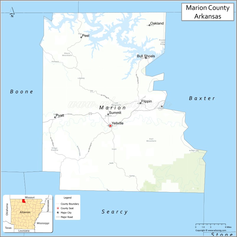
About Marion County Map, Arkansas: The map showing the county boundary, county seat, major cities, highways, water bodies and neighbouring counties.
Related Arkansas & US Links
Map of Marion County, Arkansas
Marion County is a county located in the U.S. state of Arkansas. It's county seat is Yellville. As per 2020 census, the population of Marion County is 16978 people and population density is square miles. According to the United States Census Bureau, the county has a total area of 640.39 sq mi (1,659 km2). Marion County was established on -23433.
Marion County Facts
| Continent | North America |
| Country | United States |
| State | Arkansas |
| County Seat | Yellville |
| Largest City/Town | Yellville |
| Established | 1836 |
| Total Area | 640 sq mi (1,658 sq km) |
| Land Area | 597 sq mi (1,546 sq km) |
| Water Area | 43 sq mi (111 sq km) |
| Population | 16,826 (Census 2020) |
| Population Density | 28.2 people per sq mi |
| Time Zone | Central Time Zone (CST/CDT) |
| Major Highways | US Highway 62, Arkansas Highway 14, Arkansas Highway 125 |
| Major Rivers | White River, Buffalo National River nearby |
| Neighboring Counties | Baxter County, Boone County, Newton County, Searcy County |
| Famous For | Buffalo National River access, Bull Shoals Lake, Ozark Mountain scenery, and outdoor recreation |
| Top Attractions | Bull Shoals Lake, Buffalo National River nearby, Crooked Creek, Yellville Turkey Trot Festival |
| Official Website | Official Website |
About Marion County, Arkansas
Marion County is located in north-central Arkansas in the United States and was established in 1836. The county seat and largest city is Yellville. Marion County is known for Ozark Mountain scenery, rivers and lakes, outdoor recreation, and tourism connected to Bull Shoals Lake and the nearby Buffalo National River.
Cities and Towns in Marion County, Arkansas
| City/Town | Population (Census 2020) | Latitude & Longitude |
|---|---|---|
| Yellville (county seat) | 1,204 | 36.2265°N, 92.6849°W |
| Flippin | 1,345 | 36.2812°N, 92.5985°W |
| Bull Shoals | 1,952 | 36.3834°N, 92.5813°W |
| Pyatt | 221 | 36.2790°N, 92.8405°W |
| Summit | 814 | 36.2662°N, 92.6904°W |
| Peel | Rural river community | 36.4364°N, 92.8168°W |
| Bull Shoals Lake region | Outdoor recreation area | 36.3600°N, 92.5600°W |
| Ozark Mountain region | Mountain landscape area | 36.2500°N, 92.7000°W |
Golf Courses in Marion County, Arkansas
| Golf Course | Location | Latitude & Longitude |
|---|---|---|
| Bull Shoals Lake Boat Dock & Golf Area | Bull Shoals | 36.3838°N, 92.5827°W |
| Big Creek Golf & Country Club | Mountain Home nearby | 36.3597°N, 92.3762°W |
| Twin Lakes Golf Course | Mountain Home nearby | 36.3365°N, 92.3850°W |
Roads and Highways in Marion County, Arkansas
Major highways connect the county to the Ozark Mountains, north Arkansas lakes, and Missouri communities.
- US Highway 62 - major east-west transportation route through north Arkansas
- Arkansas Highway 14 - scenic route connecting mountain and river communities
- Arkansas Highway 125 - highway serving Bull Shoals Lake recreation areas and ferry access
What Are the Neighboring Counties of Marion County
- Baxter County (east)
- Boone County (west)
- Newton County (southwest)
- Searcy County (south)
Whar Are the Top Attractions in Marion County, Arkansas
The county offers a mix of lake recreation, mountain scenery, and outdoor adventures.
- Bull Shoals Lake - boating, fishing, scuba diving, and lakeside camping
- Buffalo National River nearby - canoeing, hiking, wildlife viewing, and scenic cliffs
- Crooked Creek - nationally known smallmouth bass fishing destination
- Yellville Turkey Trot Festival - annual community celebration and Ozark tradition
- Historic downtown Yellville - local shops, restaurants, and cultural attractions
- Ozark Mountain scenic drives - panoramic overlooks and countryside views
- White River trout fishing areas - boating and guided fishing tours
- Hiking and camping trails throughout the county - outdoor recreation opportunities
- Nature photography and birdwatching areas - forests, lakes, and river habitats
- Historic churches and courthouse district - local history and architecture
- Boat docks and marinas around Bull Shoals Lake - recreation and tourism facilities
- Community fairs and Ozark heritage festivals - celebrations of local culture and traditions
What is the Distance from Marion County to Nearby Cities
The following distances are measured by road (driving).
- Yellville to Mountain Home (Baxter County), Arkansas - 23 mi (37 km)
- Yellville to Harrison (Boone County), Arkansas - 27 mi (43 km)
- Yellville to Mountain View (Stone County), Arkansas - 68 mi (109 km)
- Yellville to Springfield (Greene County), Missouri - 101 mi (163 km)
- Yellville to Branson (Taney County), Missouri - 53 mi (85 km)
- Yellville to Fayetteville (Washington County), Arkansas - 110 mi (177 km)
- Yellville to Little Rock (Pulaski County), Arkansas - 157 mi (253 km)
- Yellville to Tulsa (Tulsa County), Oklahoma - 223 mi (359 km)
- Yellville to Kansas City (Jackson County), Missouri - 274 mi (441 km)
- Yellville to St. Louis (St. Louis City), Missouri - 315 mi (507 km)
- Yellville to Memphis (Shelby County), Tennessee - 273 mi (439 km)
- Yellville to Dallas (Dallas County), Texas - 438 mi (705 km)
FAQs about Marion County
Marion County is located in north-central Arkansas in the United States.
The population of Marion County was 16,826 according to the Census 2020.
Marion County is known for Bull Shoals Lake, Buffalo National River access, Ozark scenery, and outdoor recreation.
The county is served by US Highway 62, Arkansas Highway 14, and Arkansas Highway 125.
Popular attractions include Bull Shoals Lake, nearby Buffalo National River, Crooked Creek, and the Yellville Turkey Trot Festival.
References
- QuickFacts - U.S. Census Bureau
- United States Census Bureau
- United States Geological Survey (USGS)
- National Geodetic Survey
- Official Website
- Arkansas County Map
- Ashley County Map
- Baxter County Map
- Benton County Map
- Boone County Map
- Bradley County Map
- Calhoun County Map
- Carroll County Map
- Chicot County Map
- Clark County Map
- Clay County Map
- Cleburne County Map
- Cleveland County Map
- Columbia County Map
- Conway County Map
- Craighead County Map
- Crawford County Map
- Crittenden County Map
- Cross County Map
- Dallas County Map
- Desha County Map
- Drew County Map
- Faulkner County Map
- Franklin County Map
- Fulton County Map
- Garland County Map
- Grant County Map
- Greene County Map
- Hempstead County Map
- Hot Spring County Map
- Howard County Map
- Independence County Map
- Izard County Map
- Jackson County Map
- Jefferson County Map
- Johnson County Map
- Lafayette County Map
- Lawrence County Map
- Lee County Map
- Lincoln County Map
- Little River County Map
- Logan County Map
- Lonoke County Map
- Madison County Map
- Marion County Map
- Miller County Map
- Mississippi County Map
- Monroe County Map
- Montgomery County Map
- Nevada County Map
- Newton County Map
- Ouachita County Map
- Perry County Map
- Phillips County Map
- Pike County Map
- Poinsett County Map
- Polk County Map
- Pope County Map
- Prairie County Map
- Pulaski County Map
- Randolph County Map
- St Francis County Map
- Saline County Map
- Scott County Map
- Searcy County Map
- Sebastian County Map
- Sevier County Map
- Sharp County Map
- Stone County Map
- Union County Map
- Van Buren County Map
- Washington County Map
- White County Map
- Woodruff County Map
- Yell County Map
- Alabama Counties
- Alaska boroughs
- Arizona Counties
- Arkansas Counties
- California County Map
- Colorado Counties
- Connecticut Counties
- Delaware Counties
- Florida County Map
- Georgia County Map
- Hawaii Counties
- Idaho Counties
- Illinois Counties
- Indiana Counties
- Iowa Counties
- Kansas Counties
- Kentucky Counties
- Louisiana Counties
- Maine Counties
- Maryland Counties
- Massachusetts Counties
- Michigan County Map
- Minnesota Counties
- Mississippi Counties
- Missouri Counties
- Montana Counties
- Nebraska Counties
- Nevada Counties
- New York Counties
- New Hampshire Counties
- New Jersey Counties
- New Mexico Counties
- North Carolina Counties
- North Dakota Counties
- Ohio County Map
- Oklahoma Counties
- Oregon Counties
- Pennsylvania Counties
- Rhode Island Counties
- South Carolina Counties
- South Dakota Counties
- Map of Tennessee
- Texas County Map
- Utah Counties
- Vermont Counties
- Virginia Counties
- Washington Counties
- West Virginia Counties
- Wisconsin Counties
- Wyoming Counties