Written and Fact-checked by Whereig Editors, Reviewed by Mukesh Kumar| Last Updated On: May 10, 2026
Map of Pike County - Pike County is a county located in the U.S. state of Arkansas. Pike County Map showing cities, highways, important places and water bodies. Get Where is Pike County located in the map, major cities in Pike county, population, areas, and places of interest.
Pike County Map, Arkansas
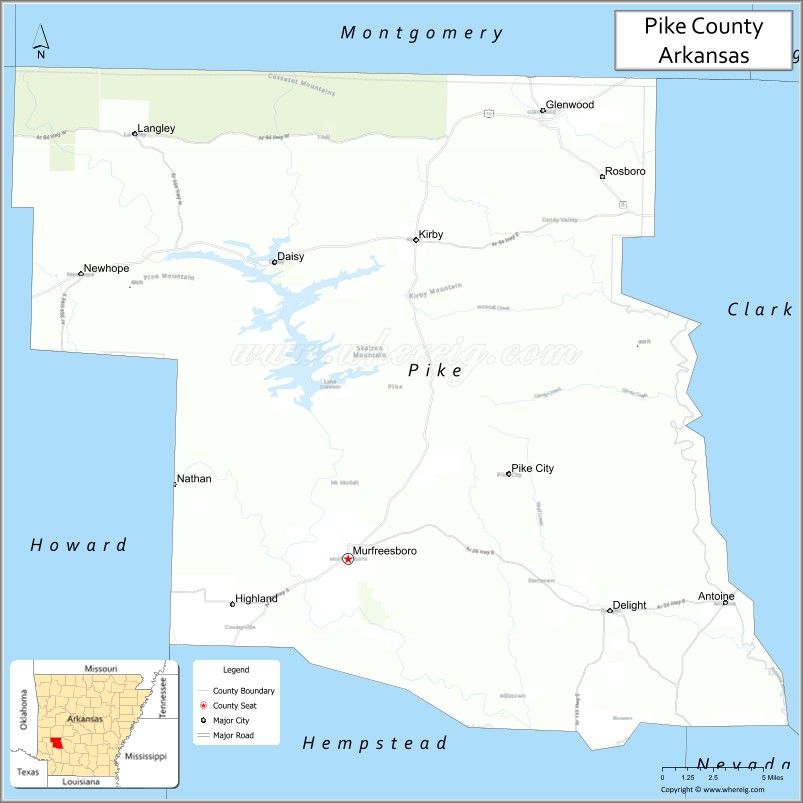
About Pike County Map, Arkansas: The map showing the county boundary, county seat, major cities, highways, water bodies and neighbouring counties.
Related Arkansas & US Links
Map of Pike County, Arkansas
Pike County is a county located in the U.S. state of Arkansas. It's county seat is Murfreesboro. As per 2020 census, the population of Pike County is 10066 people and population density is square miles. According to the United States Census Bureau, the county has a total area of 613.88 sq mi (1,590 km2). Pike County was established on -24165.
Pike County Facts
| Continent | North America |
| Country | United States |
| State | Arkansas |
| County Seat | Murfreesboro |
| Largest City/Town | Murfreesboro |
| Established | November 1, 1833 |
| Total Area | 606 sq mi (1,570 sq km) |
| Land Area | 600 sq mi (1,554 sq km) |
| Water Area | 6 sq mi (16 sq km) |
| Population | 10,171 (Census 2020) |
| Population Density | 17.0 people per sq mi |
| Time Zone | Central Time Zone (CT) |
| Major Highways | US 70, US 278, AR 8, AR 19, AR 27 |
| Major Rivers | Little Missouri River, Caddo River |
| Neighboring Counties | Montgomery County, Garland County, Clark County, Hempstead County, Howard County, Polk County |
| Famous For | Crater of Diamonds State Park, Lake Greeson, diamond mining, Ouachita Mountains |
| Top Attractions | Crater of Diamonds State Park, Lake Greeson, Daisy State Park, Little Missouri Falls |
| Official Website | Official Website |
About Pike County, Arkansas
Pike County is located in southwestern Arkansas in the United States and was established in 1833. The county seat is Murfreesboro, which is also the largest city in the county. The county is known for its scenic Ouachita Mountain landscapes, rivers, forests, and the only public diamond mining site in the United States.
Cities and Towns in Pike County, Arkansas
| City/Town | Population (Census 2020) | Latitude & Longitude |
|---|---|---|
| Murfreesboro (county seat) | 1,495 | 34.0623°N, 93.6891°W |
| Delight | 279 | 34.0301°N, 93.4952°W |
| Glenwood | 2,068 | 34.3262°N, 93.5502°W |
| Antoine | 113 | 34.0355°N, 93.4210°W |
| Kirby (CDP) | 274 | 34.2518°N, 93.6415°W |
| Newhope (CDP) | 41 | 34.2309°N, 93.8570°W |
| Langley (CDP) | 89 | 34.3116°N, 93.8414°W |
Golf Courses in Pike County, Arkansas
| Golf Course | Location | Latitude & Longitude |
|---|---|---|
| Glenwood Country Club | Glenwood | 34.3308°N, 93.5535°W |
| Pike County Golf and Recreation Area | Murfreesboro | 34.0649°N, 93.7012°W |
Roads and Highways in Pike County, Arkansas
Major highways connect the county to nearby regions and mountain recreation areas.
- US Highway 70 - major east-west route connecting Glenwood, Delight, and surrounding communities
- US Highway 278 - regional highway linking the county with Hope and Hot Springs
- Arkansas Highway 8 - scenic route through the Ouachita Mountains and forest areas
- Arkansas Highway 19 - connects Pike County with Prescott and northern Arkansas communities
- Arkansas Highway 27 - north-south highway serving local rural areas and recreation sites
What Are the Neighboring Counties of Pike County
- Montgomery County (north)
- Garland County (northeast)
- Clark County (east)
- Hempstead County (south)
- Howard County (southwest)
- Polk County (west)
Whar Are the Top Attractions in Pike County, Arkansas
The county offers a mix of natural and cultural attractions.
- Crater of Diamonds State Park - world-famous park where visitors can search for real diamonds
- Lake Greeson - scenic lake popular for fishing, boating, swimming, and camping
- Daisy State Park - lakeside recreation area with campgrounds and hiking trails
- Little Missouri Falls - scenic waterfall area in the Ouachita National Forest
- Ka Do Ha Indian Village Museum - archaeological and Native American heritage site in Murfreesboro
- Ouachita National Forest - expansive forest offering hiking, camping, and wildlife viewing
- Narrows Dam Recreation Area - popular outdoor destination along Lake Greeson
- Caddo River - river known for canoeing, kayaking, and fishing opportunities
- Caney Creek Wilderness - rugged mountain wilderness area for hiking and backpacking
- Historic Murfreesboro Downtown - charming historic district with local shops and museums
- Kirby Landing - public access area for boating and fishing on Lake Greeson
- Wolf Pen Gap Trails nearby - popular ATV and off-road trail system in the Ouachita region
What is the Distance from Pike County to Nearby Cities
The following distances are measured by road (driving).
- Murfreesboro to Hot Springs (Garland County), Arkansas - 66 mi (106 km)
- Murfreesboro to Hope (Hempstead County), Arkansas - 44 mi (71 km)
- Murfreesboro to Arkadelphia (Clark County), Arkansas - 58 mi (93 km)
- Murfreesboro to Nashville (Howard County), Arkansas - 31 mi (50 km)
- Murfreesboro to Little Rock (Pulaski County), Arkansas - 118 mi (190 km)
- Murfreesboro to Texarkana (Miller County), Arkansas - 86 mi (138 km)
- Murfreesboro to Mena (Polk County), Arkansas - 82 mi (132 km)
- Murfreesboro to Prescott (Nevada County), Arkansas - 46 mi (74 km)
- Murfreesboro to Glenwood (Pike County), Arkansas - 31 mi (50 km)
- Murfreesboro to Russellville (Pope County), Arkansas - 109 mi (175 km)
- Murfreesboro to Shreveport (Caddo Parish), Louisiana - 122 mi (196 km)
- Murfreesboro to Camden (Ouachita County), Arkansas - 63 mi (101 km)
FAQs about Pike County
Pike County is located in southwestern Arkansas within the Ouachita Mountain region of the United States.
Pike County had a population of 10,171 according to the 2020 United States Census.
Pike County is known for Crater of Diamonds State Park, diamond mining, Lake Greeson, and outdoor recreation.
The major highways include US Highway 70, US Highway 278, Arkansas Highway 8, Arkansas Highway 19, and Arkansas Highway 27.
Yes, Pike County has golf and recreation facilities including courses near Glenwood and Murfreesboro.
References
- QuickFacts - U.S. Census Bureau
- United States Census Bureau
- United States Geological Survey (USGS)
- National Geodetic Survey
- Official County Website
- Arkansas County Map
- Ashley County Map
- Baxter County Map
- Benton County Map
- Boone County Map
- Bradley County Map
- Calhoun County Map
- Carroll County Map
- Chicot County Map
- Clark County Map
- Clay County Map
- Cleburne County Map
- Cleveland County Map
- Columbia County Map
- Conway County Map
- Craighead County Map
- Crawford County Map
- Crittenden County Map
- Cross County Map
- Dallas County Map
- Desha County Map
- Drew County Map
- Faulkner County Map
- Franklin County Map
- Fulton County Map
- Garland County Map
- Grant County Map
- Greene County Map
- Hempstead County Map
- Hot Spring County Map
- Howard County Map
- Independence County Map
- Izard County Map
- Jackson County Map
- Jefferson County Map
- Johnson County Map
- Lafayette County Map
- Lawrence County Map
- Lee County Map
- Lincoln County Map
- Little River County Map
- Logan County Map
- Lonoke County Map
- Madison County Map
- Marion County Map
- Miller County Map
- Mississippi County Map
- Monroe County Map
- Montgomery County Map
- Nevada County Map
- Newton County Map
- Ouachita County Map
- Perry County Map
- Phillips County Map
- Pike County Map
- Poinsett County Map
- Polk County Map
- Pope County Map
- Prairie County Map
- Pulaski County Map
- Randolph County Map
- St Francis County Map
- Saline County Map
- Scott County Map
- Searcy County Map
- Sebastian County Map
- Sevier County Map
- Sharp County Map
- Stone County Map
- Union County Map
- Van Buren County Map
- Washington County Map
- White County Map
- Woodruff County Map
- Yell County Map
- Alabama Counties
- Alaska boroughs
- Arizona Counties
- Arkansas Counties
- California County Map
- Colorado Counties
- Connecticut Counties
- Delaware Counties
- Florida County Map
- Georgia County Map
- Hawaii Counties
- Idaho Counties
- Illinois Counties
- Indiana Counties
- Iowa Counties
- Kansas Counties
- Kentucky Counties
- Louisiana Counties
- Maine Counties
- Maryland Counties
- Massachusetts Counties
- Michigan County Map
- Minnesota Counties
- Mississippi Counties
- Missouri Counties
- Montana Counties
- Nebraska Counties
- Nevada Counties
- New York Counties
- New Hampshire Counties
- New Jersey Counties
- New Mexico Counties
- North Carolina Counties
- North Dakota Counties
- Ohio County Map
- Oklahoma Counties
- Oregon Counties
- Pennsylvania Counties
- Rhode Island Counties
- South Carolina Counties
- South Dakota Counties
- Map of Tennessee
- Texas County Map
- Utah Counties
- Vermont Counties
- Virginia Counties
- Washington Counties
- West Virginia Counties
- Wisconsin Counties
- Wyoming Counties