
Where is Howard Located? - Howard is a city located in the Cass County of Wisconsin, United States. Howard lies between 43.6489596 Degrees North latitudes and 72.3192579 Degrees West longitudes.
Location Map of Howard, Wisconsin
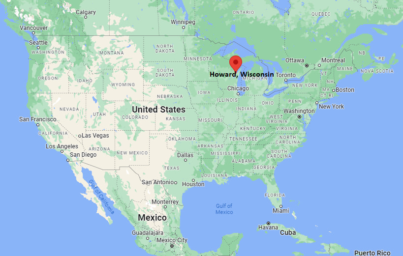
Howard Map, Wisconsin, USA
Where is Howard?: The Google Map showing the location of Howard in the U.S. state of Wisconsin.
Where is Howard Located?
Howard is a city located in the Cass County of Wisconsin, United States. Howard lies between 43.6489596 Degrees North latitudes and 72.3192579 Degrees West longitudes. According to 2020 U.S.census, the population of Howard city is 19950 people and the city has a total area of 18.45 sq mi. The city has numerous parks and recreational facilities.
Most Viewed US Maps
| USA Sttae Map | USA Region Map | USA Road Map |
| USA County Map | Where is USA in World Map? | US ZIP Code Map |
| USA Time Zones Map | US State and Capitals Map | USA Physical Map |
Find 4,400+ U.S. Cities by State - Explore Their Locations and Get Detailed Information
Howard, Wisconsin Quick Facts
| Property | Information |
|---|---|
| Village | Howard |
| County | Brown County |
| State | Wisconsin |
| State Capital | Madison |
| US Region | Midwestern United States |
| Latitude | 44.5697° N |
| Longitude | 88.0929° W |
| Elevation | 617 ft (188 m) |
| Land Area | 23.31 sq mi |
| Water Area | 0.35 sq mi |
| Total Area | 23.66 sq mi |
| Population (latest Census year) | 20,784 (2020 Census) |
| Population Density | Approximately 892 per sq mi |
| ZIP Codes | 54303, 54313 |
| Area Code | 920 |
| Time Zone Standard | Central Standard Time (CST, UTC−6) |
| Time Zone Daylight | Central Daylight Time (CDT, UTC−5) |
| Currency | US Dollar (USD) |
| FIPS Code | 55-36250 |
| Congressional District | Wisconsin's 8th Congressional District |
Nearby Cities to Howard, Wisconsin
- Green Bay, Wisconsin - South - 5 mi
- Ashwaubenon, Wisconsin - South - 8 mi
- Suamico, Wisconsin - North - 5 mi
- De Pere, Wisconsin - South - 10 mi
- Pulaski, Wisconsin - Northwest - 15 mi
- Wrightstown, Wisconsin - South - 21 mi
- Oconto, Wisconsin - North - 28 mi
- Appleton, Wisconsin - Southwest - 35 mi
- Manitowoc, Wisconsin - Southeast - 42 mi
- Sturgeon Bay, Wisconsin - Northeast - 47 mi
Driving Distances from Howard, Wisconsin
| City | State | Distance (mi) | Approx. Drive Time |
|---|---|---|---|
| Green Bay | Wisconsin | 5 | 10 minutes |
| Suamico | Wisconsin | 5 | 10 minutes |
| Ashwaubenon | Wisconsin | 8 | 15 minutes |
| De Pere | Wisconsin | 10 | 18 minutes |
| Pulaski | Wisconsin | 15 | 20 minutes |
| Wrightstown | Wisconsin | 21 | 25 minutes |
| Oconto | Wisconsin | 28 | 35 minutes |
| Appleton | Wisconsin | 35 | 40 minutes |
| Manitowoc | Wisconsin | 42 | 50 minutes |
| Sturgeon Bay | Wisconsin | 47 | 55 minutes |
Transportation and Connectivity in Howard, Wisconsin
| Transportation | Details |
|---|---|
| Airport Name | Green Bay Austin Straubel International Airport |
| IATA Code | GRB |
| Port | Port of Green Bay |
| Major Highways | Interstate 41, US Highway 41, US Highway 141, Wisconsin Highway 29 |
| Train/Amtrak Service | No passenger rail service; nearest Amtrak station in Milwaukee |
| Local Bus/Transit Service | Green Bay Metro Transit |
- Interstate 41 is the primary north-south corridor connecting Howard with Green Bay, Appleton, and Milwaukee.
- US Highway 141 provides regional access to northern Wisconsin and Michigan's Upper Peninsula.
- Wisconsin Highway 29 is a major east-west route linking Green Bay with Wausau and western Wisconsin.
- The nearby Port of Green Bay supports commercial shipping on Green Bay and Lake Michigan.
- Green Bay Austin Straubel International Airport provides scheduled passenger flights and regional air connections.
What are top Places to Visit in Howard, Wisconsin
| Landmark Name | Type |
|---|---|
| Mountain Bay State Trail | Recreation Trail |
| Duck Creek Golf Center | Recreation Facility |
| Pamperin Park | County Park |
| Green Bay Botanical Garden | Botanical Garden |
| Bay Beach Wildlife Sanctuary | Wildlife Sanctuary |
| Lambeau Field | Sports Stadium |
| National Railroad Museum | Railroad Museum |
| Neville Public Museum | History Museum |
| NEW Zoo & Adventure Park | Zoo |
| Fonferek's Glen | Nature Preserve |
Colleges and Universities in Howard, Wisconsin
| Institution Name | Type | Level | Notable For |
|---|---|---|---|
| University of Wisconsin–Green Bay | Public | University | Environmental studies, business, and nursing |
| Northeast Wisconsin Technical College | Public | Technical College | Career education and skilled trades training |
| St. Norbert College | Private | University | Liberal arts, business, and leadership programs |
| Bellin College | Private | University | Nursing and healthcare education |
| Howard-Suamico School District | Public | K–12 District | Primary and secondary public education |
Waterbodies in Howard, Wisconsin
Duck Creek, Duck Creek Quarry, Green Bay, Fox River, Suamico River, Little Suamico River, Bay of Green Bay, Lake Michigan
Golf Courses in Howard, Wisconsin
Thornberry Creek at Oneida, Duck Creek Golf Center, Hilly Haven Golf Course, Green Bay Country Club, Highland Ridge Golf Club, Shorewood Golf Course
Howard, Wisconsin — Key Historical Facts
- Howard was established as the Town of Howard in 1835 and was named after General Benjamin Howard, an early military leader in the American frontier.
- The community developed through farming, lumber production, and trade because of its location just north of Green Bay.
- Residential growth accelerated during the second half of the twentieth century as the Green Bay metropolitan area expanded into northern Brown County.
- Howard incorporated as a village in 1959 and has since become one of the fastest-growing communities in northeastern Wisconsin.
- Today, Howard is known for its family-friendly neighborhoods, excellent parks, quality schools, and convenient access to Green Bay's business, recreation, and cultural attractions.
References
Wisconsin Maps and Info
- Where is Appleton
- Where is Ashwaubenon
- Where is Beloit
- Where is Brookfield
- Where is Caledonia
- Where is Cudahy
- Where is De Pere
- Where is Eau Claire
- Where is Fitchburg
- Where is Fond du Lac
- Where is Franklin
- Where is Germantown
- Where is Green Bay
- Where is Greenfield
- Where is Howard
- Where is Janesville
- Where is Kaukauna
- Where is Kenosha
- Where is La Crosse
- Where is Manitowoc
- Where is Marshfield
- Where is Menasha
- Where is Menomonee Falls
- Where is Menomonie
- Where is Mequon
- Where is Middleton
- Where is Mount Pleasant
- Where is Muskego
- Where is Neenah
- Where is New Berlin
- Where is Oak Creek
- Where is Oconomowoc
- Where is Onalaska
- Where is Oshkosh
- Where is Pleasant Prairie
- Where is Racine
- Where is Sheboygan
- Where is South Milwaukee
- Where is Stevens Point
- Where is Sun Prairie
- Where is Superior
- Where is Watertown
- Where is Waukesha
- Where is Wausau
- Where is Wauwatosa
- Where is West Allis
- Where is West Bend
- Where is Wisconsin Rapids