
Where is Neenah Located? - Neenah is a city located in the Winnebago County of Wisconsin, United States. Neenah lies between 44.2600593 Degrees North latitudes and 72.5753869 Degrees West longitudes.
Location Map of Neenah, Wisconsin
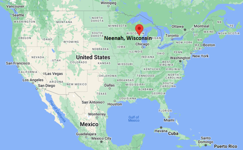
Neenah Map, Wisconsin, USA
Where is Neenah?: The Google Map showing the location of Neenah in the U.S. state of Wisconsin.
Where is Neenah Located?
Neenah is a city located in the Winnebago County of Wisconsin, United States. Neenah lies between 44.2600593 Degrees North latitudes and 72.5753869 Degrees West longitudes. According to 2020 U.S.census, the population of Neenah city is 27319 people and the city has a total area of 9.29 sq mi. The city has numerous parks and recreational facilities.
Most Viewed US Maps
| USA Sttae Map | USA Region Map | USA Road Map |
| USA County Map | Where is USA in World Map? | US ZIP Code Map |
| USA Time Zones Map | US State and Capitals Map | USA Physical Map |
Find 4,400+ U.S. Cities by State - Explore Their Locations and Get Detailed Information
Neenah, Wisconsin Quick Facts
| Attribute | Information |
|---|---|
| City | Neenah |
| County | Winnebago County |
| State | Wisconsin |
| State Capital | Madison |
| US Region | Midwest (East North Central) |
| Latitude | 44.1858° N |
| Longitude | 88.4626° W |
| Elevation | 800 ft (244 m) |
| Land Area | 9.74 sq mi |
| Water Area | 1.66 sq mi |
| Total Area | 11.40 sq mi |
| Population (2020 Census) | 27,319 |
| Population Density | Approximately 2,805 per sq mi |
| ZIP Codes | 54956 |
| Area Code | 920 |
| Time Zone Standard | Central Standard Time (CST, UTC−6) |
| Time Zone Daylight | Central Daylight Time (CDT, UTC−5) |
| Currency | United States Dollar (USD) |
| FIPS Code | 55-55750 |
| Congressional District | Wisconsin's 6th Congressional District |
Transportation and Connectivity in Neenah
| Category | Information |
|---|---|
| Airport Name | Appleton International Airport |
| IATA Code | ATW |
| Nearest Regional Airport | Wittman Regional Airport |
| Port | Lake Winnebago Water Access |
| Major Highways | Interstate 41, Wisconsin Highway 114, Wisconsin Highway 76 |
| Train Service | Freight rail service available |
| Local Transit Service | Valley Transit bus system |
- Interstate 41 provides major north–south connections between Neenah, Appleton, Green Bay, and Milwaukee.
- Wisconsin Highway 114 connects Neenah with surrounding Fox Valley communities.
- Wisconsin Highway 76 provides regional access toward western Winnebago County.
- Appleton International Airport provides commercial air service for the Fox Valley region.
Top Places to Visit in Neenah, Wisconsin
| Landmark Name | Type |
|---|---|
| Hearthstone Historic House Museum | Historic Museum |
| Riverside Park | Riverfront Park |
| Bergstrom-Mahler Museum of Glass | Art Museum |
| Doty Island | Historic Island Area |
| Shattuck Park | Waterfront Recreation Area |
| Neenah Historical Society | History Museum |
| Lake Winnebago | Lake Recreation Area |
| Fox River Trail | Multi-use Trail |
| Arrowhead Park | Community Park |
| South Park | Recreation Area |
Driving Distances from Neenah, Wisconsin to Nearby Cities
| City | State | Distance (mi) | Approx. Drive Time |
|---|---|---|---|
| Appleton | Wisconsin | 7 | 15 minutes |
| Oshkosh | Wisconsin | 15 | 20 minutes |
| Green Bay | Wisconsin | 35 | 40 minutes |
| Fond du Lac | Wisconsin | 35 | 40 minutes |
| Sheboygan | Wisconsin | 80 | 1 hour 20 minutes |
| Madison | Wisconsin | 100 | 1 hour 40 minutes |
| Milwaukee | Wisconsin | 110 | 1 hour 45 minutes |
| Wausau | Wisconsin | 100 | 1 hour 40 minutes |
| Chicago | Illinois | 190 | 3 hours |
| Minneapolis | Minnesota | 270 | 4 hours 15 minutes |
Colleges and Universities Near Neenah, Wisconsin
| Institution Name | Type | Level | Notable For |
|---|---|---|---|
| Fox Valley Technical College | Public | Technical College | Career training, technology, business, and workforce programs |
| University of Wisconsin–Oshkosh, Fox Cities Campus | Public | University Campus | Liberal arts, sciences, and undergraduate programs |
| Lawrence University | Private | University | Liberal arts, music, and interdisciplinary studies |
| University of Wisconsin–Oshkosh | Public | University | Education, business, nursing, and research programs |
| University of Wisconsin–Green Bay | Public | University | Environmental science, business, arts, and professional programs |
Waterbodies Near Neenah, Wisconsin
Lake Winnebago, Fox River, Neenah Slough, Little Lake Butte des Morts, and nearby waterways of the Fox River Valley.
Stadiums and Sports Facilities in Neenah
Neenah High School Pickett Field, Washington Park recreation facilities, Memorial Park sports fields, and nearby Fox Cities sports complexes.
Neenah, Wisconsin — Key Historical Facts
- Neenah was established in the nineteenth century along the Fox River and developed as part of the Fox River Valley settlement area.
- The name Neenah comes from a Menominee word meaning "water" or "running water," reflecting the area's Native American heritage.
- The city grew as an industrial center because of its location along important waterways and transportation routes.
- Paper manufacturing became a major industry in Neenah, contributing significantly to the growth of the Fox Valley region.
- The construction of the Fox River navigation system helped support commerce and industrial development.
- Today, Neenah is recognized for its paper industry heritage, waterfront parks, museums, historic sites, and connection to the greater Fox Cities area.
References
- City of Neenah
- Winnebago County Government
- U.S. Census Bureau
- Travel Wisconsin
- Wisconsin Department of Natural Resources
Wisconsin Maps and Info
- Where is Appleton
- Where is Ashwaubenon
- Where is Beloit
- Where is Brookfield
- Where is Caledonia
- Where is Cudahy
- Where is De Pere
- Where is Eau Claire
- Where is Fitchburg
- Where is Fond du Lac
- Where is Franklin
- Where is Germantown
- Where is Green Bay
- Where is Greenfield
- Where is Howard
- Where is Janesville
- Where is Kaukauna
- Where is Kenosha
- Where is La Crosse
- Where is Manitowoc
- Where is Marshfield
- Where is Menasha
- Where is Menomonee Falls
- Where is Menomonie
- Where is Mequon
- Where is Middleton
- Where is Mount Pleasant
- Where is Muskego
- Where is Neenah
- Where is New Berlin
- Where is Oak Creek
- Where is Oconomowoc
- Where is Onalaska
- Where is Oshkosh
- Where is Pleasant Prairie
- Where is Racine
- Where is Sheboygan
- Where is South Milwaukee
- Where is Stevens Point
- Where is Sun Prairie
- Where is Superior
- Where is Watertown
- Where is Waukesha
- Where is Wausau
- Where is Wauwatosa
- Where is West Allis
- Where is West Bend
- Where is Wisconsin Rapids