
Where is Youngsville Located? - Youngsville is a city located in the Lafayette County of Louisiana, United States. Youngsville lies between 42.4651 Degrees North latitudes and 71.0110 Degrees West longitudes.
Location Map of Youngsville, Louisiana
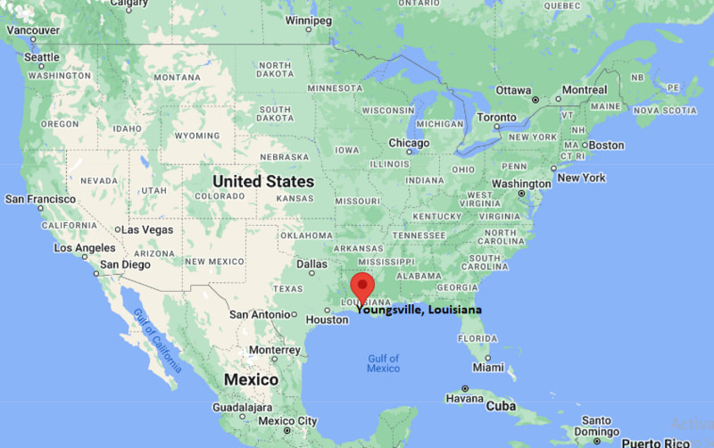
Youngsville Map, Louisiana, USA
Where is Youngsville?: The Google Map showing the location of Youngsville in the U.S. state of Louisiana.
Where is Youngsville Located?
Youngsville is a city located in the Lafayette Parish of Louisiana, United States. Youngsville lies between 42.4651 Degrees North latitudes and 71.0110 Degrees West longitudes. According to 2020 U.S.census, the population of Youngsville city is 15929 people and the city has a total area of 12.07 sq mi. The city has numerous parks and recreational facilities.
Most Viewed US Maps
| USA Sttae Map | USA Region Map | USA Road Map |
| USA County Map | Where is USA in World Map? | US ZIP Code Map |
| USA Time Zones Map | US State and Capitals Map | USA Physical Map |
Find 4,400+ U.S. Cities by State - Explore Their Locations and Get Detailed Information
Youngsville, Louisiana Quick Facts
| Attribute | Details |
|---|---|
| City | Youngsville |
| County | Lafayette Parish |
| State | Louisiana |
| State Capital | Baton Rouge |
| US Region | Southern United States |
| Latitude | 30.0997° N |
| Longitude | 91.9901° W |
| Elevation | Approximately 26 ft (8 m) |
| Land Area | 10.2 sq mi |
| Water Area | 0.1 sq mi |
| Total Area | 10.3 sq mi |
| Population (2020 Census) | 15,570 |
| Population Density | Approximately 1,530 per sq mi |
| ZIP Code | 70592 |
| Area Code | 337 |
| Time Zone Standard | Central Standard Time (CST), UTC−6 |
| Time Zone Daylight | Central Daylight Time (CDT), UTC−5 |
| Currency | United States Dollar (USD) |
| FIPS Code | 22-83795 |
| Community Type | City |
Transportation and Connectivity in Youngsville, Louisiana
| Transportation | Details |
|---|---|
| Airport Name | Lafayette Regional Airport |
| IATA Code | LFT |
| Regional Airport | Baton Rouge Metropolitan Airport |
| Port | Port of Iberia and Port of New Iberia |
| Major Highways | US Route 90, Louisiana Highway 89, Louisiana Highway 92 |
| Train/Amtrak Service | Amtrak service available in nearby Lafayette |
| Local Transit Service | Lafayette Transit System |
- US Route 90 — Major east-west highway connecting Youngsville with Lafayette, New Iberia, and other Acadiana communities.
- Louisiana Highway 89 — Important north-south route serving Youngsville and surrounding areas.
- Louisiana Highway 92 — Regional route connecting Youngsville with nearby communities and rural areas.
Top Places to Visit in Youngsville, Louisiana
| Landmark Name | Type |
|---|---|
| Youngsville Sports Complex | Sports and Recreation Facility |
| Sugar Mill Pond | Community and Recreation Area |
| Youngsville Museum | Local History Attraction |
| Acadiana Park Nature Station | Nature Center |
| Vermilion River | Natural Landmark |
| Rip Van Winkle Gardens | Botanical Garden |
| Acadian Village | Historic Cultural Attraction |
| Paul and Lulu Hilliard University Art Museum | Art Museum |
| Lake Fausse Pointe State Park | State Park |
| Acadiana Mall | Shopping Center |
Driving Distances from Youngsville, Louisiana to Nearby Cities
| City | State | Distance (mi) | Approx. Drive Time |
|---|---|---|---|
| Lafayette | Louisiana | 10 mi | 15 minutes |
| New Iberia | Louisiana | 15 mi | 20 minutes |
| Abbeville | Louisiana | 25 mi | 30 minutes |
| Breaux Bridge | Louisiana | 25 mi | 30 minutes |
| Opelousas | Louisiana | 40 mi | 45 minutes |
| Baton Rouge | Louisiana | 65 mi | 1 hour |
| Lake Charles | Louisiana | 90 mi | 1 hour 30 minutes |
| Alexandria | Louisiana | 100 mi | 1 hour 45 minutes |
| New Orleans | Louisiana | 135 mi | 2 hours 15 minutes |
| Houston | Texas | 230 mi | 3 hours 30 minutes |
Colleges and Universities Near Youngsville, Louisiana
| Institution Name | Type | Level | Notable For |
|---|---|---|---|
| University of Louisiana at Lafayette | Public | University | Engineering, nursing, business, education, computer science, and research programs |
| South Louisiana Community College | Public | Community College | Technical education, workforce training, and career programs |
| Loyola University New Orleans | Private | University | Arts, business, law, music, and liberal arts programs |
| Louisiana State University | Public | University | Research, agriculture, engineering, business, and sciences |
| Lafayette Parish School System | Public | K–12 District | Local public education |
Waterbodies Near Youngsville, Louisiana
Vermilion River, Bayou Vermilion, Bayou Tortue, Cypress Lake, and nearby Acadiana waterways
Golf Courses and Stadiums Near Youngsville
Golf Courses: Sugar Creek Country Club, Wetlands Golf Course, and nearby Lafayette Parish golf facilities. Stadiums: Youngsville Sports Complex, Cajun Field at the University of Louisiana at Lafayette, and local community sports fields.
Key Landmarks and Places to Visit in Youngsville, Louisiana
| Landmark Name | Type |
|---|---|
| Youngsville Sports Complex | Sports and Recreation Facility |
| Sugar Mill Pond | Community Development and Recreation Area |
| Acadian Village | Historic Cultural Attraction |
| Vermilion River | Natural Landmark |
| Rip Van Winkle Gardens | Botanical Garden |
| Acadiana Park Nature Station | Nature Center |
| Paul and Lulu Hilliard University Art Museum | Art Museum |
| Acadiana Mall | Shopping Center |
| Lake Fausse Pointe State Park | State Park |
| Youngsville Cultural District | Community Area |
Youngsville, Louisiana — Key Historical Facts
- The Youngsville area was originally inhabited by Native American groups of the Atakapa and related Indigenous communities of southern Louisiana.
- European settlers, including French-speaking Acadians, developed farms and communities throughout the Acadiana region.
- Youngsville was named after John Young, an early settler who established a plantation and community in the area.
- The town developed around agriculture, especially sugarcane farming, which shaped the local economy and culture.
- Youngsville was incorporated as a town in 1908 and later became a city in 1983.
- The discovery and development of nearby oil and gas resources contributed to economic growth in the Acadiana region.
- Today, Youngsville is known for its rapid residential growth, Cajun culture, recreation facilities, schools, and location near Lafayette.
References
- United States Census Bureau
- City of Youngsville Official Website
- Lafayette Parish Official Website
- State of Louisiana Official Website
- Louisiana Tourism
Louisiana Related Maps and Info
- Where is Alexandria
- Where is Baker
- Where is Bayou Blue
- Where is Bayou Cane
- Where is Bossier City
- Where is Broussard
- Where is Central
- Where is Chalmette
- Where is Claiborne
- Where is Covington
- Where is Crowley
- Where is Destrehan
- Where is Estelle
- Where is Gardere
- Where is Gonzales
- Where is Gretna
- Where is Hammond
- Where is Harvey
- Where is Houma
- Where is Kenner
- Where is Lafayette
- Where is Lake Charles
- Where is Laplace
- Where is Luling
- Where is Mandeville
- Where is Marrero
- Where is Metairie
- Where is Minden
- Where is Monroe
- Where is Morgan City
- Where is Moss Bluff
- Where is Natchitoches
- Where is New Iberia
- Where is Opelousas
- Where is Pineville
- Where is Prairieville
- Where is River Ridge
- Where is Ruston
- Where is Shenandoah
- Where is Slidell
- Where is Sulphur
- Where is Terrytown
- Where is Thibodaux
- Where is West Monroe
- Where is Woodmere
- Where is Youngsville
- Where is Zachary