
Where is Harvey Located? - Harvey is a city located in the Cook County of Louisiana, United States. Harvey lies between 42.2042586 Degrees North latitudes and 72.6162009 Degrees West longitudes.
Location Map of Harvey, Louisiana
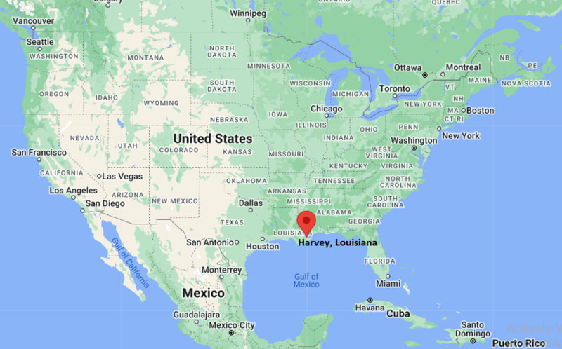
Harvey Map, Louisiana, USA
Where is Harvey?: The Google Map showing the location of Harvey in the U.S. state of Louisiana.
Where is Harvey Located?
Harvey is a city located in the Cook County of Louisiana, United States. Harvey lies between 42.2042586 Degrees North latitudes and 72.6162009 Degrees West longitudes. According to 2020 U.S.census, the population of Harvey city is 22236 people and the city has a total area of 6.49 sq mi. The city has numerous parks and recreational facilities.
Most Viewed US Maps
| USA Sttae Map | USA Region Map | USA Road Map |
| USA County Map | Where is USA in World Map? | US ZIP Code Map |
| USA Time Zones Map | US State and Capitals Map | USA Physical Map |
Find 4,400+ U.S. Cities by State - Explore Their Locations and Get Detailed Information
Harvey, Louisiana Quick Facts
| Property | Information |
|---|---|
| Census-Designated Place (CDP) | Harvey |
| County (Parish) | Jefferson Parish |
| State | Louisiana |
| State Capital | Baton Rouge |
| US Region | Southern United States |
| Latitude | 29.9035°N |
| Longitude | 90.0662°W |
| Elevation | 3 ft (1 m) |
| Land Area | 6.61 sq mi |
| Water Area | 0.41 sq mi |
| Total Area | 7.02 sq mi |
| Population (latest Census year) | 22,236 (Census 2020) |
| Population Density | Approximately 3,365 per sq mi |
| ZIP Codes | 70058, 70059 |
| Area Code | 504 |
| Time Zone Standard | Central Standard Time (CST, UTC−6) |
| Time Zone Daylight | Central Daylight Time (CDT, UTC−5) |
| Currency | US Dollar (USD) |
| FIPS Code | 22-33095 |
| Congressional District | Louisiana's 2nd Congressional District |
Nearby Cities to Harvey, Louisiana
- Gretna, Louisiana — 2 mi Northeast
- Marrero, Louisiana — 3 mi West
- Terrytown, Louisiana — 2 mi East
- Westwego, Louisiana — 4 mi Northwest
- New Orleans, Louisiana — 7 mi East
- Bridge City, Louisiana — 7 mi West
- Avondale, Louisiana — 10 mi West
- Belle Chasse, Louisiana — 11 mi South
- Elmwood, Louisiana — 12 mi Northwest
- Kenner, Louisiana — 16 mi Northwest
Driving Distances from Harvey, Louisiana
| City | State | Distance (mi) | Approx. Drive Time |
|---|---|---|---|
| Gretna | Louisiana | 2 | 5 minutes |
| Terrytown | Louisiana | 2 | 5 minutes |
| Marrero | Louisiana | 3 | 8 minutes |
| Westwego | Louisiana | 4 | 10 minutes |
| New Orleans | Louisiana | 7 | 15 minutes |
| Bridge City | Louisiana | 7 | 15 minutes |
| Belle Chasse | Louisiana | 11 | 20 minutes |
| Elmwood | Louisiana | 12 | 20 minutes |
| Kenner | Louisiana | 16 | 25 minutes |
| Baton Rouge | Louisiana | 82 | 1 hour 25 minutes |
Transportation and Connectivity in Harvey, Louisiana
| Transportation | Details |
|---|---|
| Airport Name | Louis Armstrong New Orleans International Airport |
| IATA Code | MSY |
| Port | Port of New Orleans |
| Major Highways | U.S. Route 90 Business, U.S. Route 90, Louisiana Highway 45, Louisiana Highway 18 |
| Train/Amtrak Service | Nearest Amtrak station at New Orleans Union Passenger Terminal |
| Local Bus/Transit Service | Jefferson Transit (JET) and New Orleans Regional Transit Authority (RTA) |
- U.S. Route 90 Business and the Westbank Expressway provide direct access between Harvey and downtown New Orleans.
- The nearby Crescent City Connection bridges connect the West Bank with the east bank of the Mississippi River.
- Louis Armstrong New Orleans International Airport is approximately 18 miles northwest and offers domestic and international flights.
- Jefferson Transit and New Orleans RTA provide public transportation throughout the metropolitan area.
- Harvey benefits from its location near the Port of New Orleans, one of the busiest cargo ports in the United States.
What are top Places to Visit in Harvey, Louisiana
| Landmark Name | Type |
|---|---|
| Boomtown Casino & Hotel | Casino Resort |
| Jean Lafitte National Historical Park and Preserve (Barataria Preserve) | National Park Preserve |
| Bayou Segnette State Park | State Park |
| Oakwood Center | Shopping Mall |
| Gretna Historic District | Historic District |
| Audubon Aquarium | Aquarium |
| The National WWII Museum | History Museum |
| French Quarter | Historic Neighborhood |
| Jackson Square | Historic Plaza |
| Mississippi River Riverwalk | Waterfront Attraction |
Colleges and Universities in Harvey, Louisiana
| Institution | Type | Level | Notable For |
|---|---|---|---|
| Delgado Community College – West Bank Campus | Public | Community College | Associate degrees, workforce training, and technical education |
| University of Holy Cross | Private | University | Nursing, education, business, and liberal arts |
| Loyola University New Orleans | Private | University | Law, music, business, and liberal arts |
| Tulane University | Private | University | Research, medicine, engineering, and public health |
| University of New Orleans | Public | University | Engineering, business, sciences, and research |
Waterbodies in Harvey, Louisiana
Mississippi River, Harvey Canal, Bayou Barataria, Bayou Segnette, Intracoastal Waterway, Lake Cataouatche, Lake Salvador, Gulf Intracoastal Waterway, Bayou Rigolettes, Bayou Perot
Golf Courses in Harvey, Louisiana
Timberlane Country Club, Stonebridge Golf Club of New Orleans, English Turn Golf & Country Club, Bayou Oaks at City Park (South Course), Bayou Oaks at City Park (North Course), TPC Louisiana, Joseph M. Bartholomew Golf Course, Audubon Park Golf Course
Harvey, Louisiana — Key Historical Facts
- Harvey was established in the nineteenth century and was named after Joseph Hale Harvey, who developed the community and the Harvey Canal in the 1830s.
- The Harvey Canal became an important transportation route, linking the Mississippi River with nearby bayous and wetlands to support shipping and commerce.
- During the twentieth century, Harvey experienced rapid suburban growth as the New Orleans metropolitan area expanded across the West Bank of Jefferson Parish.
- Its location along major highways and waterways encouraged the development of retail centers, healthcare facilities, and residential neighborhoods.
- Today, Harvey is recognized as a major commercial and residential community on the West Bank, offering convenient access to New Orleans, the Port of New Orleans, and numerous cultural and recreational attractions.
References
Louisiana Related Maps and Info
- Where is Alexandria
- Where is Baker
- Where is Bayou Blue
- Where is Bayou Cane
- Where is Bossier City
- Where is Broussard
- Where is Central
- Where is Chalmette
- Where is Claiborne
- Where is Covington
- Where is Crowley
- Where is Destrehan
- Where is Estelle
- Where is Gardere
- Where is Gonzales
- Where is Gretna
- Where is Hammond
- Where is Harvey
- Where is Houma
- Where is Kenner
- Where is Lafayette
- Where is Lake Charles
- Where is Laplace
- Where is Luling
- Where is Mandeville
- Where is Marrero
- Where is Metairie
- Where is Minden
- Where is Monroe
- Where is Morgan City
- Where is Moss Bluff
- Where is Natchitoches
- Where is New Iberia
- Where is Opelousas
- Where is Pineville
- Where is Prairieville
- Where is River Ridge
- Where is Ruston
- Where is Shenandoah
- Where is Slidell
- Where is Sulphur
- Where is Terrytown
- Where is Thibodaux
- Where is West Monroe
- Where is Woodmere
- Where is Youngsville
- Where is Zachary