
Where is Bloomington Located? - Bloomington is a city located in the McLean County of Illinois, United States. Bloomington lies between 40.4783 Degrees North latitudes and -88.9893 Degrees West longitudes.
Location Map of Bloomington, Illinois
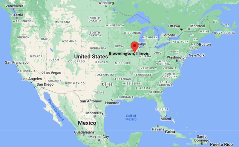
Bloomington Map, Illinois, USA
Where is Bloomington?: The Google Map showing the location of Bloomington in the U.S. state of Illinois.
Where is Bloomington Located?
Bloomington is a city located in the McLean County of Illinois, United States. Bloomington lies between 40.4783 Degrees North latitude and -88.9893 Degrees West longitude. According to the 2020 U.S. Census, the population of Bloomington city is 78,680 people and the city has a total area of 27.253 sq mi. The city has numerous parks and recreational facilities.
Most Viewed US Maps
| USA Sttae Map | USA Region Map | USA Road Map |
| USA County Map | Where is USA in World Map? | US ZIP Code Map |
| USA Time Zones Map | US State and Capitals Map | USA Physical Map |
Find 4,400+ U.S. Cities by State - Explore Their Locations and Get Detailed Information
Bloomington, Illinois Quick Facts
| Fact | Details |
|---|---|
| City | Bloomington |
| County | McLean County |
| State | Illinois |
| State Capital | Springfield |
| Country | United States |
| US Region | Midwest |
| Latitude | 40.4783 N |
| Longitude | -88.9893 W |
| Elevation | 797 ft (243 m) |
| Land Area | 27.22 sq mi |
| Water Area | 0.34 sq mi |
| Total Area | 27.253 sq mi |
| Population (Census 2020) | 78,680 |
| Population Density | Approximately 2,891 per sq mi |
| ZIP Codes | 61701, 61704, 61705 |
| Area Code | 309 |
| Time Zone Standard | Central Standard Time (CST, UTC-6) |
| Time Zone Daylight | Central Daylight Time (CDT, UTC-5) |
| Currency | United States Dollar (USD) |
| FIPS Code | 17-06613 |
| Congressional District | Illinois' 17th Congressional District |
Nearby Cities and Towns to Bloomington, Illinois
- Normal, Illinois - 2 mi North
- Downs, Illinois - 10 mi East
- Towanda, Illinois - 9 mi North
- Le Roy, Illinois - 18 mi East
- Clinton, Illinois - 24 mi South
- Pontiac, Illinois - 34 mi Northeast
- Lincoln, Illinois - 36 mi Southwest
- Peoria, Illinois - 40 mi West
- Champaign, Illinois - 54 mi Southeast
- Springfield, Illinois - 66 mi Southwest
Bloomington, Illinois Climate and Weather Overview
| Month | Avg High (°F) | Avg Low (°F) | Avg Precipitation (in) |
|---|---|---|---|
| January | 32 | 16 | 1.8 |
| April | 62 | 41 | 3.9 |
| July | 85 | 65 | 4.3 |
| October | 64 | 43 | 3.0 |
| Annual | 61 | 42 | 39.1 |
| Climate Attribute | Details |
|---|---|
| Climate Classification | Hot-Summer Humid Continental (Köppen Dfa) |
| Annual Precipitation | Approximately 39.1 inches |
| Annual Sunshine Days | About 192 days |
| Severe Weather Risk | Moderate - Thunderstorms, tornadoes, winter snow and ice storms |
| Annual Snowfall | Approximately 23 inches |
Driving Distances from Bloomington, Illinois
| City | State | Distance (mi) | Approx. Drive Time |
|---|---|---|---|
| Normal | Illinois | 2 | 5 min |
| Towanda | Illinois | 9 | 12 min |
| Downs | Illinois | 10 | 15 min |
| Le Roy | Illinois | 18 | 22 min |
| Clinton | Illinois | 24 | 30 min |
| Pontiac | Illinois | 34 | 35 min |
| Lincoln | Illinois | 36 | 40 min |
| Peoria | Illinois | 40 | 45 min |
| Champaign | Illinois | 54 | 1 hr |
| Springfield | Illinois | 66 | 1 hr 10 min |
Transportation and Connectivity in Bloomington, Illinois
| Transportation | Details |
|---|---|
| Nearest Airport | Central Illinois Regional Airport |
| IATA Code | BMI |
| Major Highways | Interstate 39, Interstate 55, Interstate 74, U.S. Route 150, Illinois Route 9 |
| Rail Service | Amtrak passenger service and Union Pacific freight rail |
| Local Transit | Connect Transit bus service |
- Interstates 39, 55 and 74 intersect in Bloomington, providing excellent highway connections across Illinois and the Midwest.
- Central Illinois Regional Airport offers scheduled commercial flights to major U.S. hubs.
- Amtrak's Lincoln Service and Texas Eagle provide passenger rail connections to Chicago, St. Louis and other destinations.
- Connect Transit operates local bus routes throughout Bloomington, Normal and the surrounding communities.
Key Landmarks and Places to Visit in Bloomington, Illinois
| Landmark | Type |
|---|---|
| McLean County Museum of History | History Museum |
| Miller Park Zoo | Zoo |
| Miller Park | City Park |
| David Davis Mansion State Historic Site | Historic House Museum |
| Constitution Trail | Multi-Use Trail |
| Children's Discovery Museum | Children's Museum |
| Ewing Cultural Center | Cultural Center |
| Uptown Normal | Shopping and Entertainment District |
| Prairie Aviation Museum | Aviation Museum |
| Evergreen Memorial Cemetery | Historic Cemetery |
Colleges and Universities in Bloomington, Illinois
| Institution | Type | Level | Notable For |
|---|---|---|---|
| Illinois State University | Public | University | Education, business and engineering technology |
| Illinois Wesleyan University | Private | Liberal Arts University | Liberal arts, music and nursing |
| Heartland Community College | Public | Community College | Career education and university transfer programs |
| Lincoln College (Bloomington Campus) | Private | Former College Campus | Historic higher education institution |
| University of Illinois Urbana-Champaign | Public | Research University | Engineering, agriculture and computer science |
| Bradley University | Private | University | Business, engineering and health sciences |
Waterbodies in Bloomington, Illinois
Evergreen Lake, Lake Bloomington, Sugar Creek, Kickapoo Creek, Mackinaw River, Money Creek, White Oak Creek, Six Mile Creek, Dawson Lake, Fox Creek.
Golf Courses in Bloomington, Illinois
The Den at Fox Creek Golf Course, Highland Park Golf Course, Ironwood Golf Course, Weibring Golf Club, The Links at Ireland Grove, Prairie Vista Golf Course, Crestwicke Country Club, Pontiac Elks Country Club.
Bloomington, Illinois - Key Historical Facts
- Bloomington was founded in 1830 and became the county seat of McLean County shortly afterward, developing as an important agricultural and commercial center.
- The arrival of the railroad in the mid-nineteenth century accelerated economic growth and established the city as a transportation hub in central Illinois.
- Bloomington played a notable role in Illinois political history, including speeches and legal work by Abraham Lincoln and other prominent leaders.
- The city became home to major insurance companies, manufacturing industries and educational institutions, strengthening its regional economy.
- Bloomington and neighboring Normal have grown together into one of central Illinois' largest metropolitan areas, supported by higher education and business.
- Today, Bloomington is recognized for its historic downtown, thriving healthcare and insurance industries, cultural attractions and excellent transportation connections.
References
Illinois Related Maps and Info
- Where is Arlington Heights
- Where is Bartlett
- Where is Belleville
- Where is Berwyn
- Where is Bloomington
- Where is Bolingbrook
- Where is Buffalo Grove
- Where is Carol Stream
- Where is Carpentersville
- Where is Champaign
- Where is Cicero
- Where is Crystal Lake
- Where is Decatur
- Where is DeKalb
- Where is Des Plaines
- Where is Downers Grove
- Where is Elgin
- Where is Elmhurst
- Where is Evanston
- Where is Glenview
- Where is Hanover Park
- Where is Hoffman Estates
- Where is Joliet
- Where is Lombard
- Where is Moline
- Where is Mount Prospect
- Where is Naperville
- Where is Normal
- Where is Oak Lawn
- Where is Oak Park
- Where is Orland Park
- Where is Palatine
- Where is Park Ridge
- Where is Peoria
- Where is Plainfield
- Where is Quincy
- Where is Rock Island
- Where is Rockford
- Where is Romeoville
- Where is Schaumburg
- Where is Skokie
- Where is Streamwood
- Where is Tinley Park
- Where is Urbana
- Where is Waukegan
- Where is Wheaton
- Where is Wheeling