
Where is Candler-McAfee Located? - Candler-McAfee is a city located in the DeKalb County of Georgia, United States. Candler-McAfee lies between 33.7272 Degrees North latitudes and -84.2747 Degrees West longitudes.
Location Map of Candler-McAfee, Georgia
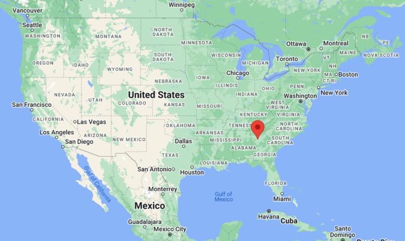
Candler-McAfee Map, Georgia, USA
Where is Candler-McAfee?: The Google Map showing the location of Candler-McAfee in the U.S. state of Georgia.
Where is Candler-McAfee Located?
Candler-McAfee is a city located in the DeKalb County of Georgia, United States. Candler-McAfee lies between 33.7272 Degrees North latitudes and -84.2747 Degrees West longitudes. According to 2020 U.S.census, the population of Candler-McAfee city is 22468 people and the city has a total area of 6.981 sq mi. The city has numerous parks and recreational facilities.
Most Viewed US Maps
| USA Sttae Map | USA Region Map | USA Road Map |
| USA County Map | Where is USA in World Map? | US ZIP Code Map |
| USA Time Zones Map | US State and Capitals Map | USA Physical Map |
Find 4,400+ U.S. Cities by State - Explore Their Locations and Get Detailed Information
Candler-McAfee, Georgia Quick Facts
| Property | Details |
|---|---|
| City | Candler-McAfee (Census-Designated Place) |
| County | DeKalb County |
| State | Georgia |
| State Capital | Atlanta |
| US Region | South |
| Latitude | 33.7272 N |
| Longitude | -84.2747 W |
| Elevation | 961 ft (293 m) |
| Land Area | 8.75 sq mi |
| Water Area | 0.08 sq mi |
| Total Area | 7.0 sq mi |
| Population (2020 Census) | 22,468 |
| Population Density | 2,568 per sq mi |
| ZIP Codes | 30032, 30034 |
| Area Code | 404, 470, 678, 770 |
| Time Zone Standard | Eastern Standard Time (EST, UTC-5) |
| Time Zone Daylight | Eastern Daylight Time (EDT, UTC-4) |
| Currency | US Dollar (USD) |
| FIPS Code | 13-12460 |
| Congressional District | 4th Congressional District |
Nearby Cities to Candler-McAfee, Georgia
- Decatur, Georgia - 4 mi North
- Avondale Estates, Georgia - 5 mi North
- Atlanta, Georgia - 8 mi Northwest
- Belvedere Park, Georgia - 2 mi North
- Panthersville, Georgia - 4 mi South
- Stone Mountain, Georgia - 10 mi Northeast
- Conley, Georgia - 8 mi South
- East Point, Georgia - 12 mi Southwest
- College Park, Georgia - 13 mi Southwest
- Lithonia, Georgia - 14 mi East
Driving Distances from Candler-McAfee, Georgia
| City | State | Distance (mi) | Approx. Drive Time |
|---|---|---|---|
| Belvedere Park | Georgia | 2 | 5 min |
| Decatur | Georgia | 4 | 10 min |
| Panthersville | Georgia | 4 | 10 min |
| Avondale Estates | Georgia | 5 | 12 min |
| Atlanta | Georgia | 8 | 20 min |
| Conley | Georgia | 8 | 15 min |
| Stone Mountain | Georgia | 10 | 20 min |
| East Point | Georgia | 12 | 25 min |
| College Park | Georgia | 13 | 25 min |
| Lithonia | Georgia | 14 | 25 min |
Transportation and Connectivity in Candler-McAfee, Georgia
| Transportation | Details |
|---|---|
| Airport Name | Hartsfield-Jackson Atlanta International Airport |
| IATA Code | ATL |
| Port | No commercial port; nearest inland freight facilities in Atlanta |
| Major Highways | Interstate 20, Interstate 285, U.S. Highway 23, U.S. Highway 278 |
| Train/Amtrak Service | Nearest Amtrak station in Atlanta |
| Local Bus/Transit Service | MARTA Bus; nearby MARTA Rail service in Decatur |
- Interstate 20 and Interstate 285 provide quick access to downtown Atlanta and surrounding metro communities.
- MARTA bus routes connect the area with Decatur Station and the wider Atlanta public transit network.
- Nearby Decatur Station offers MARTA rail service to downtown Atlanta, Midtown, Buckhead, and the airport.
- Hartsfield-Jackson Atlanta International Airport is about 15 miles southwest and serves as the region's primary air gateway.
- The community's central location provides convenient access to major employment centers, shopping districts, and educational institutions throughout metropolitan Atlanta.
Key Landmarks and Places to Visit in Candler-McAfee, Georgia
| Landmark Name | Type |
|---|---|
| East Lake Golf Club | Historic Golf Club |
| Dearborn Park | Community Park |
| Shoal Creek Park | Nature Park |
| Sugar Creek Golf and Tennis Center | Sports Complex |
| Fernbank Museum of Natural History | Museum |
| Decatur Square | Historic District |
| Stone Mountain Park | State Park |
| Georgia State Farmers Market | Market |
| South River Trail | Multi-Use Trail |
| Legacy Garden Park | Community Park |
Colleges and Universities in Candler-McAfee, Georgia
| Institution Name | Type | Level | Notable For |
|---|---|---|---|
| Georgia State University - Perimeter College (Decatur Campus) | Public | Community College | Associate degrees and university transfer programs |
| Emory University | Private | University | Research, medicine, and liberal arts |
| Agnes Scott College | Private | Liberal Arts College | Liberal arts education |
| Georgia State University | Public | University | Research and graduate education |
| DeKalb County School District | Public | K-12 District | Public education services |
Waterbodies in Candler-McAfee, Georgia
South River, Shoal Creek, Sugar Creek, Intrenchment Creek, Snapfinger Creek, Constitution Lakes, Stone Mountain Lake, DeKalb Reservoir
Golf Courses in Candler-McAfee, Georgia
East Lake Golf Club, Sugar Creek Golf and Tennis Center, Mystery Valley Golf Club, Browns Mill Golf Course, Charlie Yates Golf Course, Stone Mountain Golf Club, Cross Creek Golf Club, Smoke Rise Country Club
Candler-McAfee, Georgia - Key Historical Facts
- Candler-McAfee developed during the twentieth century as a residential community in southern DeKalb County, just east of Atlanta.
- The area experienced rapid suburban growth following World War II as Atlanta expanded and new neighborhoods were established.
- Its proximity to downtown Atlanta, major highways, and public transportation contributed to continued residential and commercial development.
- The community has long been part of the greater Atlanta metropolitan area, benefiting from nearby educational institutions, healthcare facilities, and employment centers.
- Although it remains an unincorporated census-designated place, Candler-McAfee has developed a diverse population and a strong neighborhood identity.
- Today, the community is known for its convenient location, access to parks and recreation, nearby cultural attractions, and connections to the economic opportunities of metropolitan Atlanta.
References
Most Viewed GA Maps
- Where is Acworth
- Where is Albany
- Where is Alpharetta
- Where is Candler-McAfee
- Where is Canton
- Where is Carrollton
- Where is Cartersville
- Where is Chamblee
- Where is Dalton
- Where is Decatur
- Where is Douglasville
- Where is Duluth
- Where is Dunwoody
- Where is East Point
- Where is Evans
- Where is Gainesville
- Where is Griffin
- Where is Hinesville
- Where is Johns Creek
- Where is Kennesaw
- Where is LaGrange
- Where is Lawrenceville
- Where is Mableton
- Where is Marietta
- Where is Martinez
- Where is McDonough
- Where is Milton
- Where is Newnan
- Where is Peachtree City
- Where is Perry
- Where is Pooler
- Where is Redan
- Where is Rome
- Where is Roswell
- Where is Sandy Springs
- Where is Savannah
- Where is Smyrna
- Where is Snellville
- Where is Statesboro
- Where is Stockbridge
- Where is Sugar Hill
- Where is Suwanee
- Where is Union City
- Where is Valdosta
- Where is Warner Robins
- Where is Woodstock