
Where is Johns Creek Located? - Johns Creek is a city located in the Fulton County of Georgia, United States. Johns Creek lies between 20.8372717 Degrees North latitudes and 156.3438445 Degrees West longitudes.
Location Map of Johns Creek, Georgia
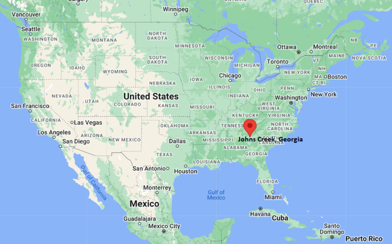
Johns Creek Map, Georgia, USA
Where is Johns Creek?: The Google Map showing the location of Johns Creek in the U.S. state of Georgia.
Where is Johns Creek Located?
Johns Creek is a city located in the Fulton County of Georgia, United States. Johns Creek lies between 20.8372717 Degrees North latitudes and 156.3438445 Degrees West longitudes. According to 2020 U.S.census, the population of Johns Creek city is 82453 people and the city has a total area of 30.81 sq mi. The city has numerous parks and recreational facilities.
Most Viewed US Maps
| USA Sttae Map | USA Region Map | USA Road Map |
| USA County Map | Where is USA in World Map? | US ZIP Code Map |
| USA Time Zones Map | US State and Capitals Map | USA Physical Map |
Find 4,400+ U.S. Cities by State - Explore Their Locations and Get Detailed Information
Johns Creek, Georgia Quick Facts
| Property | Information |
|---|---|
| City | Johns Creek |
| County | Fulton County |
| State | Georgia |
| State Capital | Atlanta |
| US Region | Southern United States |
| Latitude | 34.0289° N |
| Longitude | 84.1986° W |
| Elevation | 1,050 ft (320 m) |
| Land Area | 31.27 sq mi |
| Water Area | 0.22 sq mi |
| Total Area | 31.49 sq mi |
| Population (latest Census year) | 82,453 (2020 Census) |
| Population Density | Approximately 2,638 per sq mi |
| ZIP Codes | 30005, 30022, 30024, 30097 |
| Area Code | 470, 678, 770 |
| Time Zone Standard | Eastern Standard Time (EST, UTC−5) |
| Time Zone Daylight | Eastern Daylight Time (EDT, UTC−4) |
| Currency | US Dollar (USD) |
| FIPS Code | 13-40607 |
| Congressional District | Georgia's 6th Congressional District |
Nearby Cities to Johns Creek, Georgia
- Alpharetta, Georgia - Northwest - 6 mi
- Duluth, Georgia - East - 7 mi
- Roswell, Georgia - West - 8 mi
- Peachtree Corners, Georgia - Southeast - 9 mi
- Norcross, Georgia - South - 11 mi
- Suwanee, Georgia - Northeast - 11 mi
- Sandy Springs, Georgia - Southwest - 15 mi
- Buford, Georgia - Northeast - 20 mi
- Marietta, Georgia - West - 23 mi
- Atlanta, Georgia - South - 28 mi
Driving Distances from Johns Creek, Georgia
| City | State | Distance (mi) | Approx. Drive Time |
|---|---|---|---|
| Alpharetta | Georgia | 6 | 12 minutes |
| Duluth | Georgia | 7 | 15 minutes |
| Roswell | Georgia | 8 | 15 minutes |
| Peachtree Corners | Georgia | 9 | 18 minutes |
| Norcross | Georgia | 11 | 20 minutes |
| Suwanee | Georgia | 11 | 20 minutes |
| Sandy Springs | Georgia | 15 | 25 minutes |
| Buford | Georgia | 20 | 30 minutes |
| Marietta | Georgia | 23 | 35 minutes |
| Atlanta | Georgia | 28 | 40 minutes |
Transportation and Connectivity in Johns Creek, Georgia
| Transportation | Details |
|---|---|
| Airport Name | Hartsfield–Jackson Atlanta International Airport |
| IATA Code | ATL |
| Port | Not Applicable |
| Major Highways | Georgia State Route 120, State Route 141 (Peachtree Parkway), State Route 140 (Holcomb Bridge Road), nearby Georgia 400 |
| Train/Amtrak Service | No passenger rail service; nearest Amtrak station is Atlanta Peachtree Station |
| Local Bus/Transit Service | Xpress Commuter Bus and nearby MARTA connections |
- Georgia State Route 141 and Holcomb Bridge Road provide convenient access to Alpharetta, Roswell, Duluth, and the greater Atlanta metropolitan area.
- Nearby Georgia 400 connects Johns Creek with downtown Atlanta, Buckhead, and North Georgia.
- Hartsfield–Jackson Atlanta International Airport, about 40 miles south, offers extensive domestic and international flights.
- Xpress commuter buses and nearby MARTA services provide regional transportation options for commuters traveling to Atlanta.
- Johns Creek is recognized for its highly ranked public schools, master-planned neighborhoods, technology and healthcare businesses, and extensive parks along the Chattahoochee River.
What are top Places to Visit in Johns Creek, Georgia
| Landmark Name | Type |
|---|---|
| Autrey Mill Nature Preserve & Heritage Center | Nature Preserve & Museum |
| Newtown Park | Community Park |
| Chattahoochee River National Recreation Area | National Recreation Area |
| Cauley Creek Park | Recreation Park |
| Ocee Park | Sports Park |
| Webb Bridge Park | Community Park |
| Johns Creek Arts Center | Arts Center |
| Atlanta Athletic Club | Golf & Country Club |
| Medlock Bridge Park | Neighborhood Park |
| Big Creek Greenway | Multi-use Trail |
Colleges and Universities in Johns Creek, Georgia
| Institution Name | Type | Level | Notable For |
|---|---|---|---|
| Georgia State University – Alpharetta Center | Public | University Center | Business, computer science, nursing, education, and professional programs |
| Georgia Gwinnett College | Public | College | Business, health sciences, education, information technology, and liberal arts |
| Gwinnett Technical College | Public | Technical College | Healthcare, cybersecurity, engineering technology, business, and workforce development |
| Emory University | Private | Research University | Medicine, law, business, public health, liberal arts, and research |
| Fulton County Schools | Public | K–12 District | Primary and secondary public education serving Johns Creek |
Waterbodies in Johns Creek, Georgia
Chattahoochee River, Johns Creek, Big Creek, Wilson Creek, Suwanee Creek, Lake Lanier, Morgan Falls Reservoir, Crooked Creek
Golf Courses in Johns Creek, Georgia
Atlanta Athletic Club, Rivermont Golf Club, St. Ives Country Club, Country Club of the South, The Standard Club, RiverPines Golf
Johns Creek, Georgia — Key Historical Facts
- The area that is now Johns Creek was originally inhabited by the Cherokee Nation before European-American settlement expanded into north Georgia during the nineteenth century.
- Throughout much of its history, the community remained largely rural, with farms and small settlements along the Chattahoochee River.
- Rapid suburban development began during the 1980s and 1990s as the northern Atlanta metropolitan area expanded.
- Johns Creek officially incorporated as a city on December 1, 2006, becoming one of Georgia's newest municipalities and one of the state's largest cities by population.
- Today, Johns Creek is recognized for its nationally ranked schools, thriving technology and healthcare sectors, extensive park system, and consistently high quality of life within the Atlanta metropolitan region.
References
Most Viewed GA Maps
- Where is Acworth
- Where is Albany
- Where is Alpharetta
- Where is Candler-McAfee
- Where is Canton
- Where is Carrollton
- Where is Cartersville
- Where is Chamblee
- Where is Dalton
- Where is Decatur
- Where is Douglasville
- Where is Duluth
- Where is Dunwoody
- Where is East Point
- Where is Evans
- Where is Gainesville
- Where is Griffin
- Where is Hinesville
- Where is Johns Creek
- Where is Kennesaw
- Where is LaGrange
- Where is Lawrenceville
- Where is Mableton
- Where is Marietta
- Where is Martinez
- Where is McDonough
- Where is Milton
- Where is Newnan
- Where is Peachtree City
- Where is Perry
- Where is Pooler
- Where is Redan
- Where is Rome
- Where is Roswell
- Where is Sandy Springs
- Where is Savannah
- Where is Smyrna
- Where is Snellville
- Where is Statesboro
- Where is Stockbridge
- Where is Sugar Hill
- Where is Suwanee
- Where is Union City
- Where is Valdosta
- Where is Warner Robins
- Where is Woodstock