
Where is Evergreen Located? - Evergreen is a city located in the Avoyelles County of Montana, United States. Evergreen lies between 44.3879504 Degrees North latitudes and 71.1727881 Degrees West longitudes.
Location Map of Evergreen, Montana
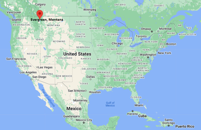
Evergreen Map, Montana, USA
Where is Evergreen?: The Google Map showing the location of Evergreen in the U.S. state of Montana.
Where is Evergreen Located?
Evergreen is a city located in the Avoyelles County of Montana, United States. Evergreen lies between 44.3879504 Degrees North latitudes and 71.1727881 Degrees West longitudes. According to 2020 U.S.census, the population of Evergreen city is 8149 people and the city has a total area of 8.55 sq mi. The city has numerous parks and recreational facilities.
Most Viewed US Maps
| USA Sttae Map | USA Region Map | USA Road Map |
| USA County Map | Where is USA in World Map? | US ZIP Code Map |
| USA Time Zones Map | US State and Capitals Map | USA Physical Map |
Find 4,400+ U.S. Cities by State - Explore Their Locations and Get Detailed Information
Evergreen, Montana Quick Facts
| Property | Details |
|---|---|
| Community | Evergreen (CDP) |
| County | Flathead County |
| State | Montana |
| State Capital | Helena |
| US Region | West |
| Latitude | 48.2266°N |
| Longitude | 114.2786°W |
| Elevation | ~3,150 ft (960 m) |
| Land Area | Approx. 7.5 sq mi |
| Water Area | Approx. 0.1 sq mi |
| Total Area | Approx. 7.6 sq mi |
| Population (2020 Census) | ~8,000 |
| Population Density | Approximately 1,000–1,100 per sq mi |
| ZIP Codes | 59901 (nearby Kalispell service area) |
| Area Code | 406 |
| Time Zone Standard | Mountain Standard Time (MST), UTC−7 |
| Time Zone Daylight | Mountain Daylight Time (MDT), UTC−6 |
| Currency | US Dollar (USD) |
| FIPS Code | 30-????? (CDP-level varies) |
| Congressional District | Montana At-Large District |
Nearby Cities to Evergreen, Montana
- Kalispell, Montana - West - 5 mi
- Columbia Falls, Montana - North - 8 mi
- Whitefish, Montana - North - 15 mi
- Bigfork, Montana - Southeast - 20 mi
- Hungry Horse, Montana - Northeast - 12 mi
- Somers, Montana - South - 10 mi
- Lakeside, Montana - South - 18 mi
- Marion, Montana - West - 15 mi
- Libby, Montana - Northwest - 90 mi
- Missoula, Montana - South - 125 mi
Evergreen, Montana Climate and Weather Overview
| Month | Avg High (°F) | Avg Low (°F) | Avg Rainfall (in) |
|---|---|---|---|
| January | 31 | 18 | 2.2 |
| April | 55 | 33 | 1.8 |
| July | 82 | 50 | 1.1 |
| October | 56 | 34 | 1.6 |
| Annual | 55 | 34 | ~18.5 |
| Climate Attribute | Details |
|---|---|
| Climate Classification (Köppen) | Humid continental (Dfb) |
| Annual Rainfall | About 18–20 inches |
| Summer Conditions | Mild to warm, low humidity |
| Winter Conditions | Cold, snowy, and long winters |
| Severe Weather Risk | Snowstorms, freezing temperatures, forest fire smoke in summer |
Driving Distances from Evergreen, Montana
| City | State | Distance (mi) | Approx. Drive Time |
|---|---|---|---|
| Kalispell | Montana | 5 | 10–15 min |
| Columbia Falls | Montana | 8 | 15 min |
| Whitefish | Montana | 15 | 20–25 min |
| Bigfork | Montana | 20 | 30 min |
| Lakeside | Montana | 18 | 25 min |
| Polson | Montana | 40 | 45–50 min |
| Libby | Montana | 90 | 1 hr 40 min |
| Missoula | Montana | 125 | 2 hr 15 min |
| Great Falls | Montana | 190 | 3 hr 15 min |
| Helena | Montana | 210 | 3 hr 30 min |
Transportation and Connectivity in Evergreen, Montana
| Transportation | Details |
|---|---|
| Airport Name | Glacier Park International Airport |
| IATA Code | FCA |
| Major Highways | US-2, US-93 (nearby), Montana Highway 35 |
| Rail Service | BNSF Railway (freight) |
| Nearest Major Airport | Missoula Montana Airport (MSO) |
| Local Transit | Limited rural transit services in Flathead Valley |
- Evergreen is part of the Flathead Valley region, close to Kalispell.
- The area is strongly influenced by tourism and outdoor recreation.
- Nearby Glacier National Park drives seasonal economic activity.
- The community is primarily residential with rural surroundings and forest landscapes.
Places to Visit in Evergreen, Montana
| Landmark Name | Type |
|---|---|
| Glacier National Park (nearby) | National Park |
| Flathead Lake | Lake Recreation Area |
| Whitefish Mountain Resort | Ski Resort |
| Hockaday Museum of Art (Kalispell) | Museum |
| Conrad Mansion Museum | Historic House Museum |
| Herron Park | City Park |
| Lone Pine State Park | State Park |
| Wayfarers State Park | State Park |
| Bigfork Summer Playhouse | Theatre |
| Wild Horse Island State Park | State Park |
Colleges and Universities in Evergreen, Montana
| Institution Name | Type | Level | Notable For |
|---|---|---|---|
| Flathead Valley Community College | Public | Community College | Associate degrees, workforce training |
| University of Montana (regional access) | Public | University | Law, forestry, environmental sciences |
| Montana State University (regional access) | Public | University | Engineering, agriculture, research |
| Montana Tech (regional access) | Public | University | Engineering and applied sciences |
| Evergreen School District (regional access) | Public | K–12 District | Primary and secondary education |
| Kalispell Public Schools (nearby) | Public | K–12 District | Regional education system |
| Whitefish School District (nearby) | Public | K–12 District | Academic and extracurricular programs |
| Northwest Montana Career Programs | Public | Technical Education | Vocational and skills training |
Waterbodies in Evergreen, Montana
Flathead River, Whitefish River, Stillwater River, Flathead Lake, Ashley Creek, Lake Blaine, Swan River (regional), Hungry Horse Reservoir (nearby)
Golf Courses in Evergreen, Montana
Buffalo Hill Golf Club, Village Greens Golf Course, Whitefish Lake Golf Club, Northern Pines Golf Club, Meadow Lake Golf Resort, Eagle Bend Golf Club, Bigfork Golf Course, Mission Mountain Golf Club
Evergreen, Montana — Key Historical Facts
- Evergreen developed as a small residential and rural community in the Flathead Valley.
- The region’s early history is tied to logging, agriculture, and railroad expansion in northwest Montana.
- Proximity to Kalispell helped shape its growth as a suburban area.
- Tourism from Glacier National Park influenced long-term economic activity.
- The Flathead Valley has long been home to Indigenous peoples, including the Kootenai and Salish tribes.
- Today, Evergreen remains a quiet residential area with strong ties to outdoor recreation and nearby urban centers.
References
Other Montana Maps & Info
- Where is Anaconda
- Where is Belgrade
- Where is Big Sky
- Where is Bigfork
- Where is Billings
- Where is Bozeman
- Where is Butte
- Where is Colstrip
- Where is Columbia Falls
- Where is Conrad
- Where is Cut Bank
- Where is Deer Lodge
- Where is Dillon
- Where is East Missoula
- Where is Evergreen
- Where is Four Corners
- Where is Glasgow
- Where is Glendive
- Where is Great Falls
- Where is Hamilton
- Where is Hardin
- Where is Havre
- Where is Helena
- Where is Helena Valley Northeast
- Where is Helena Valley Northwest
- Where is Helena Valley Southeast
- Where is Helena Valley West Central
- Where is Kalispell
- Where is Lakeside
- Where is Laurel
- Where is Lewistown
- Where is Libby
- Where is Livingston
- Where is Lockwood
- Where is Lolo
- Where is Malmstrom AFB
- Where is Manhattan
- Where is Miles City
- Where is Missoula
- Where is Montana City
- Where is North Browning
- Where is Orchard Homes
- Where is Pablo
- Where is Polson
- Where is Red Lodge
- Where is Shelby
- Where is Sidney
- Where is Stevensville
- Where is Whitefish
- Where is Wolf Point