
Where is Libby Located? - Libby is a city located in the Lincoln County of Montana, United States. Libby lies between 42.0544141 Degrees North latitudes and 104.9527501 Degrees West longitudes.
Location Map of Libby, Montana
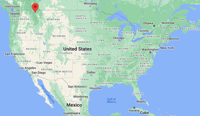
Libby Map, Montana, USA
Where is Libby?: The Google Map showing the location of Libby in the U.S. state of Montana.
Where is Libby Located?
Libby is a city located in the Lincoln County of Montana, United States. Libby lies between 42.0544141 Degrees North latitudes and 104.9527501 Degrees West longitudes. According to 2020 U.S.census, the population of Libby city is 2775 people and the city has a total area of 1.84 sq mi. The city has numerous parks and recreational facilities.
Most Viewed US Maps
| USA Sttae Map | USA Region Map | USA Road Map |
| USA County Map | Where is USA in World Map? | US ZIP Code Map |
| USA Time Zones Map | US State and Capitals Map | USA Physical Map |
Find 4,400+ U.S. Cities by State - Explore Their Locations and Get Detailed Information
Libby, Montana Quick Facts
| Attribute | Details |
|---|---|
| City | Libby |
| County | Lincoln County |
| State | Montana |
| State Capital | Helena |
| US Region | Western United States (Mountain West) |
| Latitude | 48.3883° N |
| Longitude | 115.5560° W |
| Elevation | 2,096 ft (639 m) |
| Land Area | 1.95 sq mi |
| Water Area | 0.01 sq mi |
| Total Area | 1.96 sq mi |
| Population (2020 Census) | 2,628 |
| Population Density | 1,348 per sq mi |
| ZIP Code | 59923 |
| Area Code | 406 |
| Time Zone Standard | Mountain Standard Time (MST, UTC−7) |
| Time Zone Daylight | Mountain Daylight Time (MDT, UTC−6) |
| Currency | United States Dollar (USD) |
| FIPS Code | 30-43000 |
| Congressional District | Montana At-Large Congressional District |
Transportation and Connectivity in Libby
| Category | Details |
|---|---|
| Airport Name | Libby Airport |
| IATA Code | No Commercial IATA Service |
| Port | No Commercial Port |
| Major Highways | U.S. Route 2, Montana Highway 37 |
| Train/Amtrak Service | Amtrak Empire Builder service at nearby Whitefish and Sandpoint stations |
| Local Bus/Transit Service | Lincoln County public transportation services |
- U.S. Route 2 is the primary highway connecting Libby with Kalispell, Whitefish, and eastern Montana communities.
- Montana Highway 37 provides access toward Libby Dam, Lake Koocanusa, and surrounding recreation areas.
- Nearby Amtrak Empire Builder stations provide regional passenger rail connections.
- Glacier Park International Airport near Kalispell provides commercial air service for the region.
Top Places to Visit in Libby, Montana
| Landmark Name | Type |
|---|---|
| Kootenai National Forest | National Forest |
| Libby Dam | Hydroelectric Dam & Recreation Area |
| Lake Koocanusa | Reservoir Recreation Area |
| Kootenai Falls | Waterfall & Natural Attraction |
| Kootenai Falls Swinging Bridge | Historic Recreation Site |
| Cabinet Mountains Wilderness | Wilderness Area |
| Heritage Museum | History Museum |
| Riverfront Park | Community Park |
| Cabinet View Golf Club | Golf Course |
| Ross Creek Scenic Area | Forest Recreation Area |
Driving Distances from Libby, Montana to Nearby Cities
| City | State | Distance (mi) | Approx. Drive Time |
|---|---|---|---|
| Rexford | Montana | 35 | 45 minutes |
| Kalispell | Montana | 95 | 1 hour 45 minutes |
| Whitefish | Montana | 115 | 2 hours |
| Missoula | Montana | 180 | 3 hours 15 minutes |
| Sandpoint | Idaho | 105 | 2 hours |
| Coeur d'Alene | Idaho | 150 | 3 hours |
| Spokane | Washington | 210 | 3 hours 45 minutes |
| Helena | Montana | 290 | 5 hours |
| Bozeman | Montana | 330 | 5 hours 45 minutes |
| Billings | Montana | 430 | 7 hours |
Colleges and Universities in Libby, Montana
| Institution Name | Type | Level | Notable For |
|---|---|---|---|
| Flathead Valley Community College | Public | Community College | Associate degrees, workforce training, trades, and transfer programs |
| University of Montana | Public | University | Research, liberal arts, forestry, business, and environmental sciences |
| Montana State University | Public | University | Engineering, agriculture, research, and applied sciences |
| North Idaho College | Public | Community College | Technical education, healthcare, and career programs |
| Spokane Community College | Public | Community College | Workforce education, technical programs, and professional training |
Waterbodies in Libby, Montana
Libby is located along the Kootenai River in northwestern Montana and is surrounded by several major waterways, including the Kootenai River, Lake Koocanusa, Libby Creek, and nearby Bull Lake. These water resources support fishing, boating, wildlife habitat, hydroelectric power generation, and outdoor recreation throughout Lincoln County.
Stadiums in Libby
Libby features several athletic facilities, including Libby High School's Memorial Stadium, local community sports fields, and recreation facilities operated by the city and schools. These venues host football, soccer, baseball, softball, track and field, and community sporting events.
Libby, Montana — Key Historical Facts
- Libby was established in the late nineteenth century and named after Libby Creek, which was named by early settlers in the region.
- The city grew as a timber, mining, and railroad community because of its location near rich natural resources in northwestern Montana.
- The discovery of vermiculite deposits near Libby led to the development of a major mining industry during the twentieth century.
- The area is known for its scenic location between the Cabinet Mountains and the Kootenai River valley.
- Today, Libby is recognized for its outdoor recreation opportunities, forests, rivers, wildlife, and role as a gateway to northwestern Montana wilderness areas.
References
- City of Libby
- Lincoln County Government
- U.S. Census Bureau
- Kootenai National Forest
- Montana Fish, Wildlife & Parks
Other Montana Maps & Info
- Where is Anaconda
- Where is Belgrade
- Where is Big Sky
- Where is Bigfork
- Where is Billings
- Where is Bozeman
- Where is Butte
- Where is Colstrip
- Where is Columbia Falls
- Where is Conrad
- Where is Cut Bank
- Where is Deer Lodge
- Where is Dillon
- Where is East Missoula
- Where is Evergreen
- Where is Four Corners
- Where is Glasgow
- Where is Glendive
- Where is Great Falls
- Where is Hamilton
- Where is Hardin
- Where is Havre
- Where is Helena
- Where is Helena Valley Northeast
- Where is Helena Valley Northwest
- Where is Helena Valley Southeast
- Where is Helena Valley West Central
- Where is Kalispell
- Where is Lakeside
- Where is Laurel
- Where is Lewistown
- Where is Libby
- Where is Livingston
- Where is Lockwood
- Where is Lolo
- Where is Malmstrom AFB
- Where is Manhattan
- Where is Miles City
- Where is Missoula
- Where is Montana City
- Where is North Browning
- Where is Orchard Homes
- Where is Pablo
- Where is Polson
- Where is Red Lodge
- Where is Shelby
- Where is Sidney
- Where is Stevensville
- Where is Whitefish
- Where is Wolf Point