Map of Lincoln County - Lincoln County is a county located in the U.S. state of Montana. Lincoln County Map showing cities, highways, important places and water bodies. Get Where is Lincoln County located in the map, major cities in Lincoln county, population, areas, and places of interest.
Map of Lincoln County, Montana
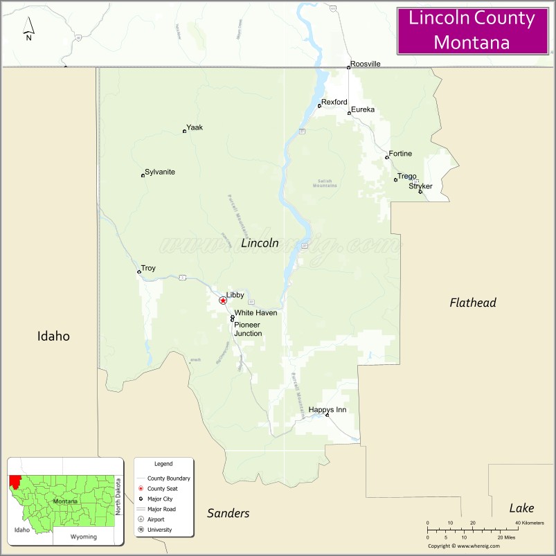
About Lincoln County Map, Montana: The map showing the county boundary, county seat, major cities, highways, water bodies and neighbouring counties.
Other Montana Maps & Info
Map of Lincoln County, Montana
Lincoln County is a county located in the U.S. state of Montana. It's county seat is Libby. As per 2020 census, the population of Lincoln County is 20525 people and population density is square miles. According to the United States Census Bureau, the county has a total area of 3,613 sq mi (9,358 km2). Lincoln County was established on 3356.
Lincoln County Facts
| Continent | North America |
| Country | United States |
| State | Montana |
| County Seat | Libby |
| Largest City/Town | Libby |
| Established | 1909 |
| Total Area | 3,675 sq mi (9,518 sq km) |
| Land Area | 3,612 sq mi (9,355 sq km) |
| Water Area | 63 sq mi (163 sq km) |
| Population | 19,112 (Census 2020) |
| Population Density | 5.3 people per sq mi |
| Time Zone | Mountain Time Zone (MST/MDT) |
| Major Highways | U.S. Route 2, U.S. Route 93, Montana Highway 37 |
| Major Rivers | Kootenai River, Yaak River |
| Neighboring Counties | Flathead County, Sanders County |
| Famous For | Kootenai National Forest, wilderness recreation, and scenic mountain landscapes |
| Top Attractions | Kootenai Falls, Cabinet Mountains Wilderness, Libby Dam, and Ross Creek Cedars Scenic Area |
| Official Website | Official Website |
About Lincoln County, Montana
Lincoln County is located in northwestern Montana in the western United States and was established in 1909. The county seat and largest city is Libby. The county is known for its rugged mountain scenery, wilderness recreation, dense forests, fishing rivers, and outdoor tourism opportunities near the Canadian border.
Cities and Towns in Lincoln County, Montana
| City/Town | Population (Census 2020) | Latitude & Longitude |
|---|---|---|
| Libby (county seat) | 2,914 | 48.3883°N, 115.5560°W |
| Troy | 938 | 48.4608°N, 115.8899°W |
| Eureka | 1,380 | 48.8783°N, 115.0530°W |
| Fortine (CDP) | 325 | 48.7641°N, 114.9026°W |
| Rexford | 107 | 48.9025°N, 115.2198°W |
| Stryker (CDP) | 41 | 48.6144°N, 114.9251°W |
Golf Courses in Lincoln County, Montana
| Golf Course | Location | Latitude & Longitude |
|---|---|---|
| Cabinet View Golf Club | Libby | 48.3939°N, 115.5634°W |
| Indian Springs Ranch Golf Course | Eureka | 48.8832°N, 115.0604°W |
Major Roads and Highways in Lincoln County, Montana
Major highways connect the county with northwestern Montana wilderness areas and regional communities.
- U.S. Route 2 - scenic east-west highway through the Kootenai Valley
- U.S. Route 93 - north-south route connecting Eureka with Flathead Valley communities
- Montana Highway 37 - scenic route along Lake Koocanusa and Libby Dam
What are the Neighboring Counties of Lincoln County
- Flathead County (east)
- Sanders County (south)
What are the top Attractions in Lincoln County, Montana
The county offers a mix of wilderness recreation, mountain scenery, and scenic river destinations.
- Kootenai Falls - scenic waterfall and suspension bridge along the Kootenai River
- Cabinet Mountains Wilderness - rugged wilderness area for hiking, camping, and wildlife viewing
- Libby Dam - large hydroelectric dam creating Lake Koocanusa recreation area
- Ross Creek Cedars Scenic Area - old-growth cedar forest with interpretive trails
- Kootenai National Forest - extensive recreation area with hiking, fishing, and camping opportunities
- Lake Koocanusa - reservoir popular for boating, fishing, and water recreation
- Eureka Historic District - mountain town with shops, dining, and historic architecture
- Yaak Valley - remote scenic valley known for wildlife and wilderness access
- Troy Museum and Visitor Center - exhibits on local logging, mining, and railroad history
- Ten Lakes Scenic Area - alpine recreation destination near the Canadian border
Distance from Lincoln County to Nearby Cities
The following distances are measured by road (driving).
- Libby to Kalispell (Flathead County), Montana - 92 mi (148 km)
- Libby to Missoula (Missoula County), Montana - 195 mi (314 km)
- Libby to Eureka (Lincoln County), Montana - 71 mi (114 km)
- Libby to Troy (Lincoln County), Montana - 18 mi (29 km)
- Libby to Spokane (Spokane County), Washington - 194 mi (312 km)
- Libby to Coeur d'Alene (Kootenai County), Idaho - 146 mi (235 km)
- Libby to Helena (Lewis and Clark County), Montana - 289 mi (465 km)
- Libby to Bozeman (Gallatin County), Montana - 370 mi (595 km)
- Libby to Great Falls (Cascade County), Montana - 291 mi (468 km)
- Libby to Seattle (King County), Washington - 511 mi (822 km)
- Libby to Calgary, Alberta - 278 mi (447 km)
- Libby to Salt Lake City (Salt Lake County), Utah - 654 mi (1,053 km)
- Libby to Denver (Denver County), Colorado - 883 mi (1,421 km)
FAQs about Lincoln County
Lincoln County is located in northwestern Montana near the Idaho and Canadian borders.
Lincoln County had a population of 19,112 according to the 2020 United States Census.
Lincoln County is known for mountain scenery, wilderness recreation, forests, and the Kootenai River region.
The county is served by U.S. Route 2, U.S. Route 93, and Montana Highway 37.
Yes, Lincoln County includes golf facilities such as Cabinet View Golf Club and Indian Springs Ranch Golf Course.
References
- QuickFacts - U.S. Census Bureau
- United States Census Bureau
- United States Geological Survey (USGS)
- National Geodetic Survey
- Official Website
- Beaverhead County Map
- Big Horn County Map
- Blaine County Map
- Broadwater County Map
- Carbon County Map
- Carter County Map
- Cascade County Map
- Chouteau County Map
- Custer County Map
- Daniels County Map
- Dawson County Map
- Deer Lodge County Map
- Fallon County Map
- Fergus County Map
- Flathead County Map
- Gallatin County Map
- Garfield County Map
- Glacier County Map
- Golden Valley County Map
- Granite County Map
- Hill County Map
- Jefferson County Map
- Judith Basin County Map
- Lake County Map
- Lewis and Clark County Map
- Liberty County Map
- Lincoln County Map
- McCone County Map
- Madison County Map
- Meagher County Map
- Mineral County Map
- Missoula County Map
- Musselshell County Map
- Park County Map
- Petroleum County Map
- Phillips County Map
- Pondera County Map
- Powder River County Map
- Powell County Map
- Prairie County Map
- Ravalli County Map
- Richland County Map
- Roosevelt County Map
- Rosebud County Map
- Sanders County Map
- Sheridan County Map
- Silver Bow County Map
- Stillwater County Map
- Sweet Grass County Map
- Teton County Map
- Toole County Map
- Treasure County Map
- Valley County Map
- Wheatland County Map
- Wibaux County Map
- Yellowstone County Map
- Alabama Counties
- Alaska boroughs
- Arizona Counties
- Arkansas Counties
- California County Map
- Colorado Counties
- Connecticut Counties
- Delaware Counties
- Florida County Map
- Georgia County Map
- Hawaii Counties
- Idaho Counties
- Illinois Counties
- Indiana Counties
- Iowa Counties
- Kansas Counties
- Kentucky Counties
- Louisiana Counties
- Maine Counties
- Maryland Counties
- Massachusetts Counties
- Michigan County Map
- Minnesota Counties
- Mississippi Counties
- Missouri Counties
- Montana Counties
- Nebraska Counties
- Nevada Counties
- New York Counties
- New Hampshire Counties
- New Jersey Counties
- New Mexico Counties
- North Carolina Counties
- North Dakota Counties
- Ohio County Map
- Oklahoma Counties
- Oregon Counties
- Pennsylvania Counties
- Rhode Island Counties
- South Carolina Counties
- South Dakota Counties
- Map of Tennessee
- Texas County Map
- Utah Counties
- Vermont Counties
- Virginia Counties
- Washington Counties
- West Virginia Counties
- Wisconsin Counties
- Wyoming Counties