Map of Glacier County - Glacier County is a county located in the U.S. state of Montana. Glacier County Map showing cities, highways, important places and water bodies. Get Where is Glacier County located in the map, major cities in Glacier county, population, areas, and places of interest.
Map of Glacier County, Montana
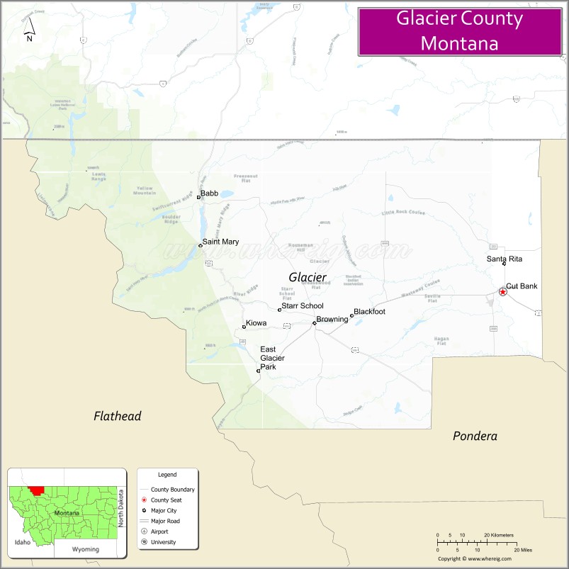
About Glacier County Map, Montana: The map showing the county boundary, county seat, major cities, highways, water bodies and neighbouring counties.
Other Montana Maps & Info
Map of Glacier County, Montana
Glacier County is a county located in the U.S. state of Montana. It's county seat is Cut Bank. As per 2020 census, the population of Glacier County is 13785 people and population density is square miles. According to the United States Census Bureau, the county has a total area of 2,995 sq mi (7,757 km2). Glacier County was established on 6988.
Glacier County Facts
| Continent | North America |
| Country | United States |
| State | Montana |
| County Seat | Cut Bank |
| Largest City/Town | Cut Bank |
| Established | 1919 |
| Total Area | 3,037 sq mi (7,866 sq km) |
| Land Area | 2,996 sq mi (7,759 sq km) |
| Water Area | 41 sq mi (106 sq km) |
| Population | 13,778 (Census 2020) |
| Population Density | 4.6 people per sq mi |
| Time Zone | Mountain Time Zone (MST/MDT) |
| Major Highways | U.S. Route 2, U.S. Route 89, Interstate 15 |
| Major Rivers | Milk River, Two Medicine River |
| Neighboring Counties | Toole County, Pondera County, Flathead County, Lewis and Clark County |
| Famous For | Glacier National Park access, Blackfeet Nation heritage, and Rocky Mountain scenery |
| Top Attractions | Glacier National Park, Two Medicine Valley, Museum of the Plains Indian, and Cut Bank Creek |
| Official Website | Official Website |
About Glacier County, Montana
Glacier County is located in northwestern Montana in the western United States and was established in 1919. The county seat and largest city is Cut Bank. The county is known for its dramatic Rocky Mountain scenery, Blackfeet Nation cultural heritage, and as an important gateway to Glacier National Park.
Cities and Towns in Glacier County, Montana
| City/Town | Population (Census 2020) | Latitude & Longitude |
|---|---|---|
| Cut Bank (county seat) | 3,105 | 48.6333°N, 112.3261°W |
| Browning | 1,018 | 48.5569°N, 113.0140°W |
| East Glacier Park Village | 538 | 48.4425°N, 113.2237°W |
| Heart Butte (CDP) | 549 | 48.2866°N, 112.8393°W |
| North Browning (CDP) | 1,992 | 48.5715°N, 113.0037°W |
| Starr School (CDP) | 238 | 48.5042°N, 113.1128°W |
Golf Courses in Glacier County, Montana
| Golf Course | Location | Latitude & Longitude |
|---|---|---|
| Cut Bank Golf & Country Club | Cut Bank | 48.6407°N, 112.3326°W |
| Glacier View Golf Recreation Area | East Glacier Park Village | 48.4395°N, 113.2278°W |
Major Roads and Highways in Glacier County, Montana
Major highways connect the county with Glacier National Park and northern Montana communities.
- U.S. Route 2 - scenic highway along the southern edge of Glacier National Park
- U.S. Route 89 - route connecting Browning with St. Mary and Great Falls
- Interstate 15 - major north-south interstate crossing eastern portions of the county region
What are the Neighboring Counties of Glacier County
- Toole County (east)
- Pondera County (south)
- Flathead County (southwest)
- Lewis and Clark County (southeast)
What are the top Attractions in Glacier County, Montana
The county offers a mix of mountain recreation, Native American culture, and scenic wilderness areas.
- Glacier National Park - world-famous national park with alpine lakes, glaciers, and mountain trails
- Two Medicine Valley - scenic valley area with hiking, boating, and wildlife viewing
- Museum of the Plains Indian - museum showcasing Blackfeet Nation art, culture, and history
- Cut Bank Creek - scenic recreation area known for fishing and dramatic canyon landscapes
- East Glacier Park Village - historic gateway community to Glacier National Park
- Blackfeet Indian Reservation - cultural region with heritage sites and scenic prairie landscapes
- St. Mary Lake nearby region - glacier-fed lake with scenic mountain views
- Glacier Park Lodge - historic lodge with classic national park architecture
- Chief Mountain Scenic Area - iconic mountain landmark near the Canadian border
- Running Eagle Falls - scenic waterfall and hiking destination in Glacier National Park
Distance from Glacier County to Nearby Cities
The following distances are measured by road (driving).
- Cut Bank to Browning (Glacier County), Montana - 35 mi (56 km)
- Cut Bank to East Glacier Park Village (Glacier County), Montana - 49 mi (79 km)
- Cut Bank to Great Falls (Cascade County), Montana - 112 mi (180 km)
- Cut Bank to Kalispell (Flathead County), Montana - 124 mi (200 km)
- Cut Bank to Helena (Lewis and Clark County), Montana - 188 mi (303 km)
- Cut Bank to Havre (Hill County), Montana - 122 mi (196 km)
- Cut Bank to Missoula (Missoula County), Montana - 243 mi (391 km)
- Cut Bank to Bozeman (Gallatin County), Montana - 285 mi (459 km)
- Cut Bank to Spokane (Spokane County), Washington - 391 mi (629 km)
- Cut Bank to Calgary, Alberta - 180 mi (290 km)
- Cut Bank to Edmonton, Alberta - 421 mi (678 km)
- Cut Bank to Seattle (King County), Washington - 624 mi (1,004 km)
- Cut Bank to Denver (Denver County), Colorado - 776 mi (1,249 km)
FAQs about Glacier County
Glacier County is located in northwestern Montana along the eastern edge of Glacier National Park.
Glacier County had a population of 13,778 according to the 2020 United States Census.
Glacier County is known for Glacier National Park access, Blackfeet Nation culture, and Rocky Mountain scenery.
The county is served by U.S. Route 2, U.S. Route 89, and Interstate 15.
Yes, Glacier County includes golf facilities such as Cut Bank Golf & Country Club and recreation golf areas near East Glacier Park Village.
References
- QuickFacts - U.S. Census Bureau
- United States Census Bureau
- United States Geological Survey (USGS)
- National Geodetic Survey
- Official Website
- Beaverhead County Map
- Big Horn County Map
- Blaine County Map
- Broadwater County Map
- Carbon County Map
- Carter County Map
- Cascade County Map
- Chouteau County Map
- Custer County Map
- Daniels County Map
- Dawson County Map
- Deer Lodge County Map
- Fallon County Map
- Fergus County Map
- Flathead County Map
- Gallatin County Map
- Garfield County Map
- Glacier County Map
- Golden Valley County Map
- Granite County Map
- Hill County Map
- Jefferson County Map
- Judith Basin County Map
- Lake County Map
- Lewis and Clark County Map
- Liberty County Map
- Lincoln County Map
- McCone County Map
- Madison County Map
- Meagher County Map
- Mineral County Map
- Missoula County Map
- Musselshell County Map
- Park County Map
- Petroleum County Map
- Phillips County Map
- Pondera County Map
- Powder River County Map
- Powell County Map
- Prairie County Map
- Ravalli County Map
- Richland County Map
- Roosevelt County Map
- Rosebud County Map
- Sanders County Map
- Sheridan County Map
- Silver Bow County Map
- Stillwater County Map
- Sweet Grass County Map
- Teton County Map
- Toole County Map
- Treasure County Map
- Valley County Map
- Wheatland County Map
- Wibaux County Map
- Yellowstone County Map
- Alabama Counties
- Alaska boroughs
- Arizona Counties
- Arkansas Counties
- California County Map
- Colorado Counties
- Connecticut Counties
- Delaware Counties
- Florida County Map
- Georgia County Map
- Hawaii Counties
- Idaho Counties
- Illinois Counties
- Indiana Counties
- Iowa Counties
- Kansas Counties
- Kentucky Counties
- Louisiana Counties
- Maine Counties
- Maryland Counties
- Massachusetts Counties
- Michigan County Map
- Minnesota Counties
- Mississippi Counties
- Missouri Counties
- Montana Counties
- Nebraska Counties
- Nevada Counties
- New York Counties
- New Hampshire Counties
- New Jersey Counties
- New Mexico Counties
- North Carolina Counties
- North Dakota Counties
- Ohio County Map
- Oklahoma Counties
- Oregon Counties
- Pennsylvania Counties
- Rhode Island Counties
- South Carolina Counties
- South Dakota Counties
- Map of Tennessee
- Texas County Map
- Utah Counties
- Vermont Counties
- Virginia Counties
- Washington Counties
- West Virginia Counties
- Wisconsin Counties
- Wyoming Counties