Map of Jefferson County - Jefferson County is a county located in the U.S. state of Montana. Jefferson County Map showing cities, highways, important places and water bodies. Get Where is Jefferson County located in the map, major cities in Jefferson county, population, areas, and places of interest.
Map of Jefferson County, Montana
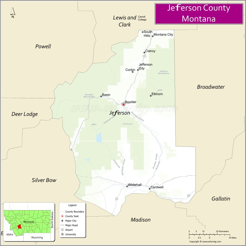
About Jefferson County Map, Montana: The map showing the county boundary, county seat, major cities, highways, water bodies and neighbouring counties.
Other Montana Maps & Info
Map of Jefferson County, Montana
Jefferson County is a county located in the U.S. state of Montana. It's county seat is Boulder. As per 2020 census, the population of Jefferson County is 12470 people and population density is square miles. According to the United States Census Bureau, the county has a total area of 1,657 sq mi (4,292 km2). Jefferson County was established on -12749.
Jefferson County Facts
| Continent | North America |
| Country | United States |
| State | Montana |
| County Seat | Boulder |
| Largest City/Town | Clancy |
| Established | 1865 |
| Total Area | 1,659 sq mi (4,297 sq km) |
| Land Area | 1,657 sq mi (4,292 sq km) |
| Water Area | 2 sq mi (5 sq km) |
| Population | 12,221 (Census 2020) |
| Population Density | 7.4 people per sq mi |
| Time Zone | Mountain Time Zone (MST/MDT) |
| Major Highways | Interstate 15, U.S. Route 287, Montana Highway 2 |
| Major Rivers | Jefferson River, Boulder River |
| Neighboring Counties | Lewis and Clark County, Broadwater County, Gallatin County, Madison County, Silver Bow County, Deer Lodge County |
| Famous For | Historic mining communities, mountain recreation, and scenic river valleys |
| Top Attractions | Lewis and Clark Caverns State Park nearby region, Elkhorn Ghost Town, Jefferson River Valley, and Boulder Hot Springs |
| Official Website | Official Website |
About Jefferson County, Montana
Jefferson County is located in southwestern Montana in the western United States and was established in 1865. The county seat is Boulder, while Clancy is the largest community. The county is known for its scenic mountain valleys, mining history, outdoor recreation, and historic towns connected to Montana’s early territorial era.
Cities and Towns in Jefferson County, Montana
| City/Town | Population (Census 2020) | Latitude & Longitude |
|---|---|---|
| Boulder (county seat) | 1,829 | 46.2369°N, 112.1197°W |
| Clancy (CDP) | 1,714 | 46.4410°N, 111.9854°W |
| Whitehall | 1,038 | 45.8705°N, 112.0967°W |
| Cardwell | 914 | 45.8602°N, 111.9458°W |
| Jefferson City (CDP) | 311 | 46.3872°N, 112.0229°W |
| Basin (CDP) | 255 | 46.2521°N, 112.2717°W |
Golf Courses in Jefferson County, Montana
| Golf Course | Location | Latitude & Longitude |
|---|---|---|
| Old Works Golf Course | Nearby Anaconda Region | 46.1298°N, 112.9483°W |
| Whitehall Country Club | Whitehall | 45.8738°N, 112.1051°W |
Major Roads and Highways in Jefferson County, Montana
Major highways connect the county with southwestern Montana cities and recreation destinations.
- Interstate 15 - major north-south interstate linking Helena, Boulder, and Butte
- U.S. Route 287 - scenic route through river valleys and mountain landscapes
- Montana Highway 2 - regional route serving historic mining communities
What are the Neighboring Counties of Jefferson County
- Lewis and Clark County (north)
- Broadwater County (east)
- Gallatin County (southeast)
- Madison County (south)
- Silver Bow County (southwest)
- Deer Lodge County (west)
What are the top Attractions in Jefferson County, Montana
The county offers a mix of mountain recreation, historic mining sites, and scenic valleys.
- Lewis and Clark Caverns State Park nearby region - famous limestone caverns and hiking trails
- Elkhorn Ghost Town - preserved mining ghost town with historic buildings and mountain scenery
- Jefferson River Valley - scenic river corridor popular for fishing and wildlife viewing
- Boulder Hot Springs - historic hot springs resort and wellness destination
- Basin Historic District - mining-era town with preserved architecture and local history
- Continental Divide Trail Access Areas - hiking and outdoor recreation routes
- Whitehall Community Heritage Sites - railroad and ranching history attractions
- Beaverhead-Deerlodge National Forest nearby region - camping, hiking, and mountain recreation
- Jefferson County Museum - exhibits on mining, ranching, and pioneer history
- Cardwell Scenic Areas - countryside views and recreation opportunities near the Jefferson River
Distance from Jefferson County to Nearby Cities
The following distances are measured by road (driving).
- Boulder to Helena (Lewis and Clark County), Montana - 27 mi (43 km)
- Boulder to Butte (Silver Bow County), Montana - 39 mi (63 km)
- Boulder to Bozeman (Gallatin County), Montana - 86 mi (138 km)
- Boulder to Whitehall (Jefferson County), Montana - 33 mi (53 km)
- Boulder to Clancy (Jefferson County), Montana - 15 mi (24 km)
- Boulder to Anaconda (Deer Lodge County), Montana - 67 mi (108 km)
- Boulder to Missoula (Missoula County), Montana - 141 mi (227 km)
- Boulder to Great Falls (Cascade County), Montana - 119 mi (192 km)
- Boulder to Kalispell (Flathead County), Montana - 260 mi (418 km)
- Boulder to Idaho Falls (Bonneville County), Idaho - 239 mi (385 km)
- Boulder to Salt Lake City (Salt Lake County), Utah - 472 mi (760 km)
- Boulder to Spokane (Spokane County), Washington - 353 mi (568 km)
- Boulder to Denver (Denver County), Colorado - 708 mi (1,139 km)
FAQs about Jefferson County
Jefferson County is located in southwestern Montana between Helena and Butte.
Jefferson County had a population of 12,221 according to the 2020 United States Census.
Jefferson County is known for historic mining communities, scenic mountain valleys, and outdoor recreation.
The county is served by Interstate 15, U.S. Route 287, and Montana Highway 2.
Yes, Jefferson County includes golf facilities such as Whitehall Country Club and nearby recreation golf courses.
References
- QuickFacts - U.S. Census Bureau
- United States Census Bureau
- United States Geological Survey (USGS)
- National Geodetic Survey
- Official Website
- Beaverhead County Map
- Big Horn County Map
- Blaine County Map
- Broadwater County Map
- Carbon County Map
- Carter County Map
- Cascade County Map
- Chouteau County Map
- Custer County Map
- Daniels County Map
- Dawson County Map
- Deer Lodge County Map
- Fallon County Map
- Fergus County Map
- Flathead County Map
- Gallatin County Map
- Garfield County Map
- Glacier County Map
- Golden Valley County Map
- Granite County Map
- Hill County Map
- Jefferson County Map
- Judith Basin County Map
- Lake County Map
- Lewis and Clark County Map
- Liberty County Map
- Lincoln County Map
- McCone County Map
- Madison County Map
- Meagher County Map
- Mineral County Map
- Missoula County Map
- Musselshell County Map
- Park County Map
- Petroleum County Map
- Phillips County Map
- Pondera County Map
- Powder River County Map
- Powell County Map
- Prairie County Map
- Ravalli County Map
- Richland County Map
- Roosevelt County Map
- Rosebud County Map
- Sanders County Map
- Sheridan County Map
- Silver Bow County Map
- Stillwater County Map
- Sweet Grass County Map
- Teton County Map
- Toole County Map
- Treasure County Map
- Valley County Map
- Wheatland County Map
- Wibaux County Map
- Yellowstone County Map
- Alabama Counties
- Alaska boroughs
- Arizona Counties
- Arkansas Counties
- California County Map
- Colorado Counties
- Connecticut Counties
- Delaware Counties
- Florida County Map
- Georgia County Map
- Hawaii Counties
- Idaho Counties
- Illinois Counties
- Indiana Counties
- Iowa Counties
- Kansas Counties
- Kentucky Counties
- Louisiana Counties
- Maine Counties
- Maryland Counties
- Massachusetts Counties
- Michigan County Map
- Minnesota Counties
- Mississippi Counties
- Missouri Counties
- Montana Counties
- Nebraska Counties
- Nevada Counties
- New York Counties
- New Hampshire Counties
- New Jersey Counties
- New Mexico Counties
- North Carolina Counties
- North Dakota Counties
- Ohio County Map
- Oklahoma Counties
- Oregon Counties
- Pennsylvania Counties
- Rhode Island Counties
- South Carolina Counties
- South Dakota Counties
- Map of Tennessee
- Texas County Map
- Utah Counties
- Vermont Counties
- Virginia Counties
- Washington Counties
- West Virginia Counties
- Wisconsin Counties
- Wyoming Counties